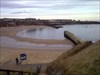
If you stand at the published co-ordinates and look north, you will have a great view of Cullercoats Bay. You are also standing on top of a major tectonic fault, the Ninety Fathom Fault (don’t worry, it’s not an active fault!). A fault is a fracture in the earth’s crust. The rocks in the bay to the north are from the Permian geological period, whereas the rocks on the headland you are standing on (and on the headland to the north) are Carboniferous. The rocks in the bay have been displaced about 500 feet downward because of the fault. This means much younger rocks from the Permian period are at the same horizontal level as much older rocks from the Carboniferous period.
The Permian sandstones can be seen at the base of the cliff you are standing on top of (walk down the steps in front of you), and look very different to the Carboniferous sandstones and shales you can see exposed in the cliffs to the north, across the bay. The magnesian limestone is exposed in Marden Quarry about 1km west of this location. This was an important quarry until the middle of the 19th Century, and almost the only location north of the River Tyne where the magnesian limestone outcrops. The Permian rocks are generally softer than the surrounding Carboniferous rocks. Cullercoats Bay, and the wider coastline here, are important for birdlife.
To log this Earthcache:
Take a photo of you / your GPSr at the site and upload it with your log (optional)
Email us the answers to these questions:
1. Look at the information board close by. What type of protected / conservation area is Cullercoats Bay, according to the map on the information board?
2. The fault-line lies in front of you as you look north, it is running roughly east-west. Describe what you see in front of you.
3. Describe the shape of Cullercoats bay.
4. Explain how the presence of a major tectonic fault might have contributed to the formation of the bay?
We hope you enjoy your visit.