The Sunbury Village Green was created as a result of the closure of Stawell Street to traffic. Stawell Street provided a key link between the early settlement of Sunbury along Macedon Street and the commercial precinct that later blossomed with the opening of the railway in 1859. The street ran diagonally from the front of the Memorial Hall to the corner of Brook and O’Shanassy Streets. The alignment is evident from the avenue of elm and oak trees.

On one side is the triangular reserve established for St.Mary’s Church of England (now Anglican) and on the other lay St.Andrews Presbyterian Church (now Uniting). Both these churches have significant buildings associated with them.
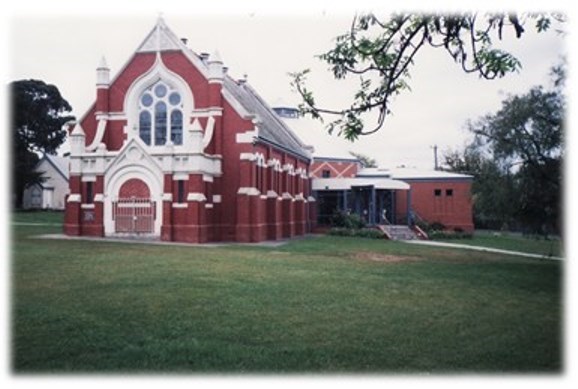
St. Andrews include:
- the original timber church (1870) now used as a hall.
- 1904 red brick church with 1986 extensions
Further information can be found at: http://www.churchhistories.net.au/church-catalog/sunbury-vic-st-andrews-uniting.
The stone fence on Brook Street is not original but adds to the setting as do the pine and peppercorn trees planted in the ninetieth century.
St. Mary’s includes:
- Bluestone Church (1867 – 1918)
- Red brick church hall and vicarage.

Further information can be found at: https://www.google.com.au/#q=St.Mary%E2%80%99s+Church+of+England+sunbury+au+images
It features a number of wonderful stained glass windows.

Further information can be found at: https://fergusonandurie.wordpress.com/2012/06/22/1880-st-marys-anglican-church-sunbury-victoria/
In 1972 Stawell Street was closed to traffic for a convention focussed on better lifestyle concepts organised by The Royal Australian Institute of Architects ‘Sunbury Fair’ Following this landmark event in town planning, the convention building was removed to Rupertswood but Stawell Street was not reopened. This established a memorial precinct at the Barkley Street junction with:
- Memorial Hall (formerly the 1885 Mechanics Institute
- War Memorial

Further information can be found at: http://monumentaustralia.org.au/themes/conflict/multiple/display/33618-sunbury-war-memorial/photo/3
The Sunbury Gun
– a 1864 cannon used by The Rupertswood Battery

Further information can be found at: http://artilleryvic.org.au/History_of_Artillery_in_Vic_Pt1.pdf
Please try to maintain the security of the hide by keeping a watch out for muggles as this is a high traffic area and they can approach or be watching from any direction including sitting in cars.
Enjoy.