 |
Grotte di Castellana |
|
Le grotte
Le Grotte di Castellana sono un complesso di cavità sotterranee di origine carsica di interesse speleologico e turistico, situato nel comune italiano di Castellana Grotte, in Puglia.
Le Grotte di Castellana furono scoperte nel 1938 dallo speleologo Franco Anelli. Estese per circa 3 chilometri, si aprono a 330 m s.l.m. sull'altopiano carsico delle Murge sud orientali che si formò nel Cretaceo superiore circa 90-100 milioni di anni fa. Il punto di massima profondità raggiunge i 122 metri. L'intero territorio comunale è caratterizzato da rocce calcaree composte essenzialmente da carbonato di calcio, prevalentemente del tipo calcare di Altamura.
L'ingresso naturale alle grotte è un'enorme voragine profonda 60 metri denominata la Grave. Per la visita al pubblico, sono previsti due itinerari:
- Itinerario completo, della lunghezza di 3 km e della durata di 120 minuti circa
- Itinerario parziale, della lunghezza di 1 km e della durata di 50 minuti circa
Vi consiglio di percorrere l'itinerario completo per la spettacolarità delle ultime sale.
 |
| Mappa itinerari |
Le Grotte di Castellana sono aperte tutto l'anno. Per gli orari di visita, che variano da stagione a stagione, si consiglia di consultare il calendario a questo link.
La temperatura media nel sottosuolo si aggira attorno ai 16,5°C. Per l’escursione si consiglia quindi di indossare abbigliamento adatto alla temperatura del sottosuolo e scarpe comode e antiscivolo.
NB: le foto all’interno delle grotte sono vietate, per favore rispettate questo divieto per non rovinare le grotte stesse.
La Grave
La storia della Grave inizia nel Cretaceo superiore (90-100 milioni di anni fa), quando la Puglia era sommersa da un antico mare, nel quale vivevano vaste colonie di molluschi e vegetali marini. Per milioni di anni generazioni e generazioni di queste forme di vita si erano succedute le une alle altre e, morendo, i loro gusci svuotati e le loro carcasse si erano accumulati sul fondo del mare, formando un gigantesco deposito di fango e di sabbia, che con il suo lento ma continuo accrescimento si era via via compresso, fino a formare uno strato di calcare dello spessore di diversi chilometri. Oggi questo tipo di calcare viene chiamato "calcare di Altamura", A partire da 65 milioni di anni fa, il progressivo innalzamento delle terre aveva portato la regione al suo aspetto attuale e nella massa calcarea emersa, a causa della sua rigidità, si erano formate estese fratture, che l’avevano fortemente incisa. L'acqua fluviale d’intense precipitazioni, percolando nel sottosuolo aveva, poi, formato un'estesa falda acquifera sotterranea, tale da disciogliere gradualmente il calcare e di allargare le fratture; queste avevano finito per unirsi le une alle altre per il crollo della roccia frapposta, formando, così, piccoli condotti, via via trasformatisi in ambienti sempre più ampi. Nei luoghi in cui le fratture s’intersecavano in gran numero si erano determinati estesi e ripetuti crolli; questi si erano ampliati sempre più verso l’alto, riducendo via via lo spessore di roccia che separava la cavità dall'esterno, finché lo strato residuo, ormai assottigliato, non era crollato, facendo giungere all'interno della grotta il primo raggio di luce.
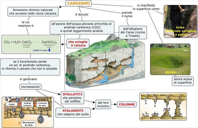
Il carsismo
Il termine carsismo indica l'attività chimica esercitata dall'acqua, soprattutto su rocce calcaree, sia di dissoluzione sia di precipitazione. La parola ha origine dal nome della regione dove inizialmente questo fenomeno è stato studiato, il Carso. E' un altopiano roccioso calcareo che si estende nel nord-est dell'Italia attraverso la Slovenia occidentale e l'Istria settentrionale.
Con il progredire degli studi sul carsismo è diventato evidente che questo tipo di terreno è uno dei più interessanti paesaggi del suolo terrestre. Le varie espressioni del carsismo si distinguono principalmente per il tipo di substrato roccioso sul quale avvengono. In Italia si conoscono principalmente le forme di carsismo su rocce a matrice calcarea e dolomitica, ma altrove esso si manifesta anche in rocce sedimentarie costituite da sale e da gesso. Da recenti studi si è scoperta una particolare forma di attività carsica persino in alcune rocce vulcaniche.
Il carsismo generalmente si articola in due fasi (dissolutiva e costruttiva) che possono alternarsi all'infinito, a seconda di come varia l'equilibrio della saturazione in H2O della CO2 nella reazione chimica reversibile fondamentale seguente:
-
La fase dissolutiva è operata dallo scorrimento superficiale o ipogeo di precipitazioni rese acide dall'anidride carbonica presente nell'atmosfera
-
La fase costruttiva si ha quando l'acqua sotterranea, arricchita (fino alla saturazione) di carbonato acido di calcio, sfociando per esempio nell'atmosfera di una grotta, lo rilascia sotto forma di carbonato di calcio insolubile.
Il carsismo quindi si sviluppa principalmente a seguito della dissoluzione chimica delle rocce calcaree. Il processo rientra nel grande insieme delle azioni di disgregazione compiute dagli agenti esogeni a spese delle rocce affioranti sulla crosta terrestre.
I complessi fenomeni chimici di dissoluzione e precipitazione in ambiente carsico possono essere chimicamente così sintetizzati:

Contrariamente al carbonato di calcio [CaCO3] praticamente insolubile, il bicarbonato di calcio [Ca(HCO3)2] è solubile in acqua in ioni Ca2+ e HCO3- che vengono asportati dall'acqua dilavante. L'evoluzione del carsismo procede in profondità creando cavità ipogee, arrestandosi solo al contatto con rocce non sottoposte, per contenuto mineralogico, al fenomeno di dissoluzione carsica.
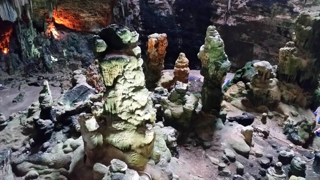
Le grotte sono senza dubbio le forme più conosciute di carsismo sotterraneo. Oltre che forme erosive sono abbondanti le forme deposizionali del carsismo. Infatti, lo stillicidio dell'acqua che penetra dalla superficie crea, con il passare dei secoli e millenni, fantastiche strutture calcaree. Le forme più caratteristiche sono le stalattiti, le stalagmiti, le colonne date dalla loro unione, le colate, le cortine e le varie concrezioni che ornano le pareti delle grotte sotterranee.
 |
| Schema riassuntivo del carsismo |
LOG:
Prima di registrare il ritrovamento rispondete alle seguenti domande inviandomi un messaggio tramite il mio profilo. I log senza permesso verranno cancellati.
Domande:
-
Le coordinate iniziali puntano all'ingresso naturale della Grave, valuta le dimensioni di questo foro nel terreno (profondità della Grave e diametro del foro).
-
Scendendo nella Grave dalla biglietteria, conta i gradini dall'ingresso fino al primo balcone.
-
Secondo te la Grave è un abisso o un inghiottitoio? Che differenza c'è tra i due?
-
Quali sono i colori predominanti delle concrezioni? A cosa sono dovute queste colorazioni?
-
Durante l'itinerario completo potrete ammirare delle stalattiti eccentriche, formazioni, di dimensioni generalmente ridotte, che non obbediscono alla legge di gravità come le normali stalattiti. Esse si accrescono infatti lateralmente, a semicerchio e perfino verso l'alto, dando vita a forme spettacolari.
Quale potrebbe essere la causa per la formazione di queste stalattiti?
-
Aggiungi una foto di te e del tuo GPS.

 |
Castellana Caves |
|
The caves
The Castellana Caves are a remarkable system of Karst caves located in the municipality of Castellana Grotte, in the province of Bari, Apulia. They are one of the most famous show caves of Italy. They have been discovered in 1938 by the speleologist Franco Anelli.
The Caves of Castellana are situated in the south-eastern Murge, a limestone plateau dating back to the upper Cretaceous (90-100 million years ago) and rising 330 metres above sea level. The cave system is about 3 kms long and the point of maximum depth reaches 122 metres. The temperature within the caves is about 16,5°C. The area of Castellana is characterized by limestone, a sedimentary rock composed largely of calcium carbonate, known as Limestone of Altamura.The natural entrance to the caves is a huge chasm called the Grave.
To visit the caves you can choose between two routes:
- Complete route, 3 kms in length with a duration of about 120 minutes
- Partial route, 1 km in length with a duration of about 50 minutes
I recommend you to take the complete itinerary as the last rooms are amazing..
|
| Itineraries map |
The Castellana Caves are open all the year. For visiting hours, which vary from season to season, keep an eye at the schedule at this link.
The average temperature in the caves is around 16.5°C. For the hike you are advised to wear suitable clothing according to this temperature and comfortable and anti-slippery shoes.
NOTE: Taking pictures inside the caves is forbidden, please respect this prohibition to keep the caves safe.
The Grave
The story of the Grave begins in the Upper Cretaceous (90-100 millions of years ago), when Apulia was submerged by an ancient sea and populated by huge colonies of shellfish and marine plants. For millions of years, generations of these life forms had succeeded one to each other and, dying, their emptied shells and their carcasses had accumulated on the sea floor, forming a giant deposit of mud and sand. With its slow but steady growth, this deposit, gradually compressed to form a layer of limestone with a thickness of several kilometers. Today this type of limestone is called "Limestone of Altamura". 65 millions of years ago, the gradual raise of the land had brought the region to its actual position. In the emerged limestone mass, due its rigidity, extensive fractures had formed, which had strongly affected the mass itself. The water of heavy rainfall, percolating into the ground had, then, formed an extensive underground aquifer that was able to dissolve the limestone and gradually enlarge the fractures. The fractures joined one to each other due the collapse of the rocks amongst them. So they formed small conducts that gradually turned into ever-widening chambers. In places where the fractures intersected in large numbers we had extended and repeated collapses; these expanded more and more upwards, gradually reducing the thickness of rock separating the cavity from the outside, until the residual layer, now thinned, collapsed, allowing the first beam of light to reach the inside of the cave.
Karst
The term karst indicates the chemical activity done by the water, especially on limestone rocks, both of dissolution and precipitation. The word originates from the name of the region where this phenomenon has been initially studied, the Karst Plateau. It is a limestone plateau region extending from northeastern Italy through southwestern Slovenia and Istria.
With the progress of the studies about the karst, it became clear that this type of soil is one of the most interesting landscapes of the Earth's crust. The various expressions of karst are distinguished mainly by the type of bedrock on which they occur. In Italy we know mainly the forms of karst out of limestone and dolomite rocks, but elsewhere it is also seen in sedimentary rocks consisting of salt and gypsum. Recent studies have discovered a particular form of karst activity even in some volcanic rocks.
The karst is generally divided into two phases (dissolutive and constructive) that may alternate perpetually, depending on how the balance of saturation of CO2 in H2O varies in the basic reversible chemical reaction.
-
The dissolutive phase is operated by the sliding surface or underground rainfall made acidic by carbon dioxide in the atmosphere
-
The constructive phase is when the underground water, enriched (up to saturation) of calcium hydrogen carbonate, flows for example in a cave, releases it in the form of insoluble calcium carbonate.
The karst develops mainly as a result of the chemical dissolution of limestone. The process is part of the large set of actions undertaken by the disintegration of exogenous agents against the rocky outcrops on the Earth's crust.
The complex chemical phenomena of dissolution and precipitation in karst environment can be chemically synthesized as follows :
At the contrary of calcium carbonate [CaCO3] that’s practically insoluble, calcium bicarbonate [Ca(HCO3)2] is soluble in water. The evolution of the karst proceeds in depth by creating underground cavities, stopping only when in contact with rocks not subjected to the phenomenon of karst dissolution. The caves are without any doubts the most well known forms of underground karst. In very rare and special conditions other mechanisms may also play an important role. Besides erosive forms depositional karst forms are abundant too. In fact, the trickle of water that penetrates the surface creates, in the centuries and millennia, fantastic limestone structures. The most characteristic forms are the stalactites, stalagmites, columns dating from their union, the shields, the curtains and the various concretions adorning the walls of the underground caves.
TO LOG:
Before logging this cache as visited, please send me the replies to the following questions using the link in my profile. Logs without permission will be deleted.
Questions:
-
The initial coordinates point to the natural entrance of the Grave, evaluate the size of this hole in the ground (diameter and depth).
-
Going down into the Grave (from the tickets booth), count the steps from the entrance to the first balcony.
-
In your opinion, is the Grave an abyss or a ponor? What's the difference between them?
-
What are the predominant colors of the concretions? Why?
-
During the complete route (only) you can admire eccentric stalactites, these formations, usually reduced in size, don't obey the law of gravity as normal stalactites. They in fact increase laterally, in a semicircle and even upwards, originating spectacular forms.
What could be the cause for the formation of these stalactites?
-
Add a picture of you and your GPS.

