Die Gallengrotte beim Ebnisee
Die Gallengrotte ist seit 1974 ein geschütztes Naturdenkmal im Welzheimer Wald (Geotop-Nr. 9356/3141). Sie liegt inmitten des Naturparks Schwäbisch-Fränkischer Wald, welcher im Jahr 1979 gegründet wurde und eine Fläche von rund 900 km2 umfasst.

Eingang zur Grotte
Geologie
Die Region um Rems und Murr ist geprägt von zahlreichen, oft sehr steil eingeschnittenen Schluchten (oft als "Klinge" bezeichnet), die typisch für das Keuperbergland sind. Charakteristisch für diese Klingen ist, dass sie meist in gerundeten, grottenförmigen Felsformationen enden. Diese Grotten beruhen auf der unterschiedlichen, stets wechselnden Beschaffenheit und Härte des anstehenden Stubensandsteins, der dem Zeitalter des Oberen Keupers zugeordnet wird (entstanden vor etwa 200 Millionen Jahren). Neben den Sandsteinschichten gehören Ton-, Mergel- und Kalksteine zu den Hauptgesteinsschichten des Oberen Keupers. In Süddeutschland beträgt die Mächtigkeit dieser Gesteinsschichten maximal etwa 45 m. In den abgelagerten Schichten sind in geringen Mengen Fossilien wie Muschelkrebse, Schnecken und Armfüßer zu finden.
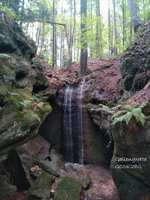
Die Gallengrotte ist die einzige von ehemals drei Grotten, die noch erhalten und frei zugänglich ist. Sie ist im hinteren Teil geprägt von bis zu 7m hohen Felsen, die stellenweise durch Algenbewuchs schwarz-grün gefärbt sind und an denen je nach Jahreszeit und Wettersituation Wasser an den Felswänden herabrieselt. Aufgrund der hydrologischen Verhältnisse ist die Gallengrotte ein wichtiger Lebensraum für feuchtigkeits- und schattenliebende Pflanzen wie Moose und Farne. Zahlreiche Bäume wie Buchen, Bergahorn und Weißtannen wachsen auf Felsvorsprüngen oder ragen in die Felsformation hinein und vermitteln so ein Bild von Urwüchsigkeit, wie sie typisch für eine Keuperschlucht ist.
(Quellen: Ministerium für Umwelt, Klima und Energiewirtschaft Baden-Württemberg / Landesamt für Geologie, Rohstoffe und Bergbau, Freiburg / Naturpark Schwäbisch-Fränkischer Wald / wikipedia.de)
Geschichte
Häufig wird zur Erklärung des Namens der Grotte die folgende Geschichte erzählt, die sich Gustav Kircher im Jahre 1930 ausdachte: Demnach versteckte Heinz, Sohn eines rachesüchtigen Germanenanführers, nach der Erstürmung des Limes den römischen Centurio Gallus und dessen schöne Tochter, in die er verliebt war, eine Zeit lang in den Gallengrotten. Nachdem sich die Wogen geglättet hatten, konnten alle drei die Grotte verlassen und lebten gemeinsam auf Heinz´ Hof. In Wirklichkeit ist der Name aber auf die Glasherstellung zurückzuführen. Vor Jahrhunderten war diese Region ein Zentrum der Glasmacherei. Die 27 Glashütten dieser Gegend produzierten eine Vielzahl an Glaswaren, wobei auch eine beträchtliche Menge an Schlacke entstand. Diese grünfarbene Schlacke wurde "Galle" genannt und in der Gallengrotte "entsorgt". Mit etwas Glück kann man heute noch Reste davon in der Grotte finden.
(Quellen: schwaebisch-sibirien.de / Gemeinde Kaisersbach / Audioguide Fremdenverkehrsgemeinschaft Schwäbischer Wald e.V.)
Zugang
Ausgangspunkt für die Wanderung zur Gallengrotte ist der kostenpflichtige Parkplatz (siehe Wegpunkt PP) an der Südseite des malerisch gelegenen Ebnisees, der auch als "Perle des Schwäbischen Waldes" bezeichnet wird. Von hier aus folgt man entweder dem Wanderweg am Westufer (Terrain 2) oder dem Wanderweg am Ostufer (Terrain 1) bis zum Nordufer des Ebnisees. Hier beginnt der Salbengehrenweg, dem man weiter Richtung Norden folgt. Kurz vor dem Gallenhöfle erreicht man eine Wegkreuzung (siehe Wegpunkt KR). Von hier aus lässt sich die Grotte auf zwei Wegen erreichen.
- Weg 1: Folgt man dem Schotterweg nach rechts, so gelangt man nach ca. 800 m an ein Schild mit der Aufschrift "Gallengrotte" (siehe Wegpunkt W1). Hier einfach links abbiegen und nach ca. 20 m steht man vor einer Infosäule, hinter der ein steiler Weg hinab zur Grotte führt (Terrain 3,5). An der Infosäule ist eine Telefonnummer für einen Audioguide zur Geschichte der Gallengrotte zu finden (Tel. 07192-9790-324).
- Weg 2: Folgt man dem asphaltierten Weg weiter gerade aus, so erreicht man nach ca. 350 m einen Abzweig nach rechts mit dem Schild "Zur Gallengrotte" (siehe Wegpunkt W2). Nach ca. 450 m entlang des Baches erreicht man die Grotte (Terrain 2,5).
Aufgrund der Lage der Grotte sind Wanderschuhe und ausreichende Kondition erforderlich. Der Besuch der Grotte geschieht auf eigene Gefahr (beachte Attribute)!
Aufgaben
- Im Eingangsbereich der Grotte siehst Du über Deinem Kopf einen knapp 1 m hohen Bereich, wo sich zahlreiche Sandsteinschichten übereinander abgelagert haben. Schätze die Anzahl und Dicke der Schichten und beschreibe deren verschiedene Färbungen.
- Betrachte und befühle einen der herabgestürzten Sandsteinbrocken. Beschreibe die Eigenschaften des Gesteins (Härte, Abriebfestigkeit, Porosität). Würdest Du aus diesem Material ein Bauwerk errichten? Begründe Deine Antwort.
- Beschreibe anhand der Informationen im Listing und mit Deinen eigenen Erkenntnissen vor Ort, wie diese Grotte entstanden sein könnte.
- Optional: Mache ein Foto oder eine Skizze vor Ort und füge es Deinem Logeintrag hinzu.
Schicke uns die Antworten via Message. Du darfst sofort loggen, bei Unklarheiten melden wir uns. Logs ohne Zusendung der Antworten werden kommentarlos gelöscht.
Grotto "Gallengrotte" at lake "Ebnisee"
The grotto "Gallengrotte" is a protected natural monument since 1974 in the forest "Welzheimer Wald" (geotope no. 9356/3141). It is located in the midst of the protected area "Schwäbisch-Fränkischer Wald", which was established in 1979 and covers an area of approximately 900 square kilometer.

Entrance to grotto
Geology
The region around the rivers "Rems" and "Murr" is characterized by numerous, often very steep ravines (often referred as "Klinge"), which are typical of the mountains "Keuperbergland". It is a characteristic of these "Klinge", that they usually end in rounded, grotto-like rock formations. These grottos are based on different, always changing composition and hardness of the upcoming sandstone (here "Stubensandstein" as a layer), which is associated with the age of the Upper Trias / Keuper (originated 200 million years ago). In addition to the layers of sandstone clay, marl and limestone are the main rock formation of the Upper Trias / Keuper. In southern Germany, the thickness of these rock formations is at most 45 meters. In the deposited layers are found in small amounts fossils such as ostracods, gastropods and brachiopods.
The grotto "Gallengrotte" is the only one out of formerly three grottos, which still exists and is accessible. In the back it is marked of up to 7 meters high rocks, that are partially colored by black-green algae. Depending on the season and weather conditions water trickles down on the rock. Due to the hydrological conditions the grotto is an important habitat for moisture and shade loving plants such as mosses and ferns. Numerous trees such as beeches, sycamore maples and white firs grow on rocky outcrops or extend into the rock formation. So they provide a real picture of originality, as is typical for a Keuper ravine.
(Sources: Ministerium für Umwelt, Klima und Energiewirtschaft Baden-Württemberg / Landesamt für Geologie, Rohstoffe und Bergbau, Freiburg / Naturpark Schwäbisch-Fränkischer Wald / wikipedia.de)
History
For explanation of the name of the grotto, the following story of Gustav Kircher (1930) is told: After the escalade of Limes, Heinz, the son of a vengeful Teutonic leader, hid the Roman Centurio Gallus and his pretty daughter in the grotto for a while, because he was in love with the daughter. When things have calmed down all of them could leave the grotto and lived together on Heinz courtyard. In reality the name can be attributed to the manufacture of glass. Centuries ago this region was a center of glassmaking. The 27 glassworks of this area produced a wide range of glassware and a substantial amount of slag was accumulated. This green-colored slag was called "Galle" (bile) and it was "disposed of" in the grotto. If you are lucky you can still find tremnants of it in the grotto.
(Sources: schwaebisch-sibirien.de / Gemeinde Kaisersbach / Audioguide Fremdenverkehrsgemeinschaft Schwäbischer Wald e.V.)
Access
Starting point for the hike to the grotto is the car park (with costs; see waypoint PP) on the south side of the picturesque lake "Ebnisee", also referred as the "Pearl of the Swabian Forest". From here you can either follow the trail on the west side (terrain 2) or the trail on the east side (terrain 1) to the north side of the lake. Here the trail "Salbengehrenweg" begins. Follow the trail northbound. You will reach a crossroad just before the courtyard "Gallenhöfle" (see waypoint KR). From here, the grotto can be reached in two ways.
- Path 1: Follow the gravel path to the right for 800 meters and you will find a sign "Gallengrotte" (see waypoint W1). Go 20 meters to the left. Here you can find an information pillar. Behind the pillar a steep path down to the grotto begins (terrain 3.5). At the information pillar you can find a telephone number (07192-9790-324). When you call the number an audio guide with information about the history of the grotto is available.
- Path 2: Follow the paved path straight ahead for 350 meters and you will reach a crossroad with a sign "Zur Gallengrotte" on the right hand side (see waypoint W2). Follow the gravel path to the right for 450 meters (along the creek, terrain 2.5).
Due to the location of the grotto hiking boots and sufficient physical condition are required. The visit of the grotto is at your own risk (observe the attributes)!
Tasks
- At the entrance of the grotto you can see above your head a nearly 1 meter high area where numerous layers of sandstone lie on the top of each other. Predict the number and thickness of layers and describe their different colors.
- Consider and palpate one of the fallen sandstone boulders. Describe the properties of the rock (hardness, abrasion resistance, porosity). Would you build a building out of this material? Give reasons for your answer.
- Describe with your own words how the grotto may have been formed. Use the information from this listing and your own insights at the grotto.
- Optional: Take a photo or make a sketch of the site and add it to your log.
Send us the answers via message. You can log the cache as a found immediately. If there is anything to clarify, we will contact you. Logs without sending the answers will be deleted without any comment.
Achtung / Attention
Für die Beantwortung der Fragen ist es nicht notwendig und aus Naturschutzgründen nicht sinnvoll, oberhalb der Grotte herumzuklettern. Schützt die Natur und bleibt auf den Wegen!
To answer the questions, it is not necessary and for the protection of the nature it makes no sense to climb above the grotto. Protect the nature and stay on the official trails.
Banner Gallengrotte
(Vielen Dank an remmak21 ;-)
<a href="https://coord.info/GC5K28G" target="_blank"><img src="https://s3.amazonaws.com/gs-geo-images/076df083-c68a-4765-ac59-6d986cdd0c7e_l.jpeg" alt="HP" width="512" height="683" border="0"/></a>