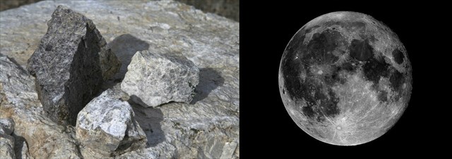
Anorthosite is an interesting and unusual white or grayish-white igneous rock composed nearly entirely of calcium-rich plagioclase feldspar. Anorthosite masses are relatively rare on Earth, and when they occur, they tend to be very old Precambrian rocks. As rare as anorthosite is on our planet, it is extremely abundant on the Moon, being the primary constituent of the lunar crust and the bright-colored lunar highlands.
If you approached the cache area from the south, you passed through the relatively young Mt. Josephine granodiorite, with an age of about 80 million years. This younger igneous rock intruded the much older anorthosite body with an age of 1.2 billion years, or about 15 times older. This is some of the oldest rock found in the San Gabriel Range, and when it formed over a billion years ago before the rise of multicellular life forms, the planet was ruled by life no more complex than communities of microbial organisms.
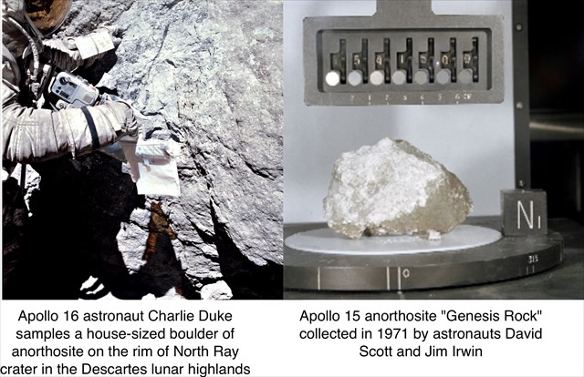
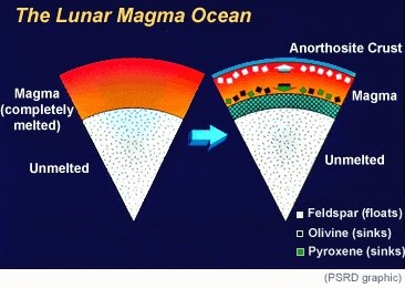 Whether occurring on the Earth or on the Moon, anorthosite is formed by the crystallization of plagioclase feldspar from a cooling body of molten magma. In the case of the Moon, shortly after its giant impact formation early in the history of the Solar System, it was so tremendously hot that the entire planet was covered by a deep molten magma ocean. As the Moon subsequently cooled and began to solidify, the plagioclase slowly crystallized at the top to form the anorthosite of the primitive lunar crust. Subsequent geologic activity on the Moon produced the dark-colored basaltic lava flows that we see today as the lunar maria, but the bulk of the Moon's primitive anorthosite crust remains visible as the light-colored lunar highlands. The Apollo astronauts returned samples of this ancient anorthosite that dates back over 4 billion years to the earliest history of the Solar System.
The Earth's geologic history has been much more active and complex than that of the Moon, and as a result most of the direct evidence of its earliest one billion years has been erased. While the San Gabriel anorthosite is not as old as the Moon's crust, it does record a similar process of crystallization in a cooling magma body on Earth over a billion years ago.
Earthcache Waypoints
(1) Your experience begins at the posted coordinates, at Baughman Springs along the Angeles Forest Highway north of the Monte Cristo ranger station. An ample turnout provides an opportunity to pull off the highway and park on the west side; if approaching from the south, take care in crossing the approaching lanes to park. Here on the west side of the highway, the road cut exposes the bright white anorthosite rock where you can touch it and examine it up close. Some of the rock at this location remains strong and competent, but much of it has a brittle crumbly or chalky texture as weathering has begun the process of breaking it down into clay. Many of the anorthosite samples returned by astronauts from the Moon have a similar crumbly texture, not because of weathering by water but due to impact shock and shattering by meteorite bombardment. You'll notice a range of colors here. Some of the exposure is nearly pure white anorthosite, while nearby can be found darker colored gabbros that contain darker iron and titanium-bearing minerals. (See photo above comparing anorthosite and darker gabbro samples.) Looking up on the roadcut, you should take note of a dark band of gabbroic rock and other dark minerals cutting through the white anorthosite.
(2) You can walk along the highway (carefully) or drive your car about 0.2 miles south to the turnout for the next waypoint on the west side of the highway. This location was formerly a wider turnout but has been largely filled with waste-rock debris by highway operations. Access to the road cut rising above the fill is an easy stroll up a gravel access road. Vehicular access is blocked by a couple of rather nice boulders of white crystalline anorthosite that are worth examining. Walk past them a short distance to the Magma Crystallization waypoint, where you should have a good view of the structures on display.
As crystals slowly formed in the cooling magma, they settled under the influence of gravity into banded layers that are visible here. Also visible is an arrowhead-shaped mass of feldspar crystals that grew upward from the floor of the magma chamber, forming a roughly conical "spire". Although the bands were horizontal when originally formed, a billion years of tectonic movement and uplift have tilted over these layers and spires considerably. Take note of this.
(3) A short walk a bit south brings you to the next waypoint. Here at the south end of the road cut, the dark gabbro accompanying the anorthosite outcrops takes on a distinctive appearance. The grayish gabbro here surrounds black crystals of ilmenite, a titanium-rich mineral also unusually abundant on the Moon. The result is the "leopard-spot" gabbro on display before you here. Take note of it before returning to your car for the drive to the final waypoint.
(4) To reach the final waypoint, you'll be driving about two miles south, past the Monte Cristo campground and ending near the Monte Cristo ranger station. Along this drive, notice the outcrops and road cuts on the west side of the road that continue to show off the white and black anorthosite/gabbro formations. An optional stop at the "Last Exposure" reference waypoint offers a final road cut where you can examine the anorthosite close-up before it comes to an abrupt end just past the ranger station. When you finally stop at the last waypoint, there is a southbound pullout just beyond the ranger station entrance. Here you see Mt. Josephine granodiorite taking the place of the anorthosite of the past two miles. Take note of its different appearance.
Logging requirements
Send me a note with :
- The text "GC5KAPD San Gabriel Anorthosite - Earthcache or Mooncache?" on the first line
- The number of people in your group.
- At the first (Baughman Springs) waypoint, estimate the thickness of the prominent dark gabbro layer within the lighter anorthosite.
- At the second (Magma Crystallization) waypoint, identify the layering and crystallization spire visible there; describe the direction and amount of tilting of the crystallized magma body from its original orientation by tectonic movement.
- At the third (Leopard Spot Gabbro) waypoint, describe the appearance and size of the features that give this formation its name.
- At the final waypoint, describe the appearance of the Mt. Josephine granodiorite visible in the nearby roadcut, and contrast it with the anorthosite you have been seeing until this point.
Please feel free to post photos of your exploration of the area.
The following sources were used in generating this Earthcache:
- Robert P. Sharp. A Field Guide to Southern California, 3rd Edition. Dubuque, IA: Kendall/Hunt Publishing, 1994
- Arizona State Univ. Apollo Image Archive, http://apollo.sese.asu.edu/LIW/20080722.html