Español

El topónimo "Fontibre" hace referencia al nacimiento del Ebro, pues deriva del latín Fontes Iberis («fuentes del Ebro»)
Aquí se ha ubicado tradicionalmente el nacimiento del río Ebro, a pesar de que, en términos científicos, esto no es exacto, pues es sabido que el origen principal de las aguas del río Ebro es el río Híjar. Investigaciones realizadas por el Instituto Geológico y Minero de España realizadas en 1987, pudieron determinar con certeza que el afloramiento de Fontibre tiene su origen en el río Híjar, que nace en el circo de pico Tres Mares.
Lo que aquí encontraremos es una “surgencia kárstica”, que es considerada como en nacimiento del Rio Ebro
Modelado Karst
“Karst” es un término aplicado a áreas donde la disolución extensa de roca ha conducido al desarrollo de canales subterráneos por los cuales las aguas subterráneas fluyen en conductos (canales cubiertos o semi-cubiertos). Estos conductos pueden variar en el tamaño, desde grietas ligeramente ampliadas a túneles con unos diámetros de varios metros y muchos kilómetros de longitud.
Las formaciones “Karst” se producen sobre todo en áreas con una base de carbonato, por lo general calizas y “dolostones.
Las áreas de topografía karst están caracterizadas por rasgos naturales como “sinkholes” (agujeros), que a menudo son vistos como charcas circulares o depresiones desde el exterior. Otros rasgos de karst comunes son cavernas, surgencias, y pocas o ningunas corrientes continuas en la superficie.
La evolución de topografía karst se diferencia considerablemente de paisajes más típicos donde la erosión y la deposición por el agua corriente esculpen la superficie de tierra. En la topografía karst, las rocas subyacentes solubles son quitadas por disolución en lugar de por erosión.
Surgencias Kársticas
Las aguas subterráneas que se filtran por grietas quitan la roca soluble dejando un canal ampliado para que más (y cada vez más más eficiente) fluya del agua. Si hay una cubierta gruesa de suelo encima de la roca soluble, pueden fluir corrientes superficiales encima del sistema de drenaje subterráneo karst. Pero más comúnmente, los rasgos de disolución ocurren en la superficie, y por esto hay pocas corrientes continuas superficiales, porque al final encuentra sinkholes u otras maneras de encaminarse al subsuelo.
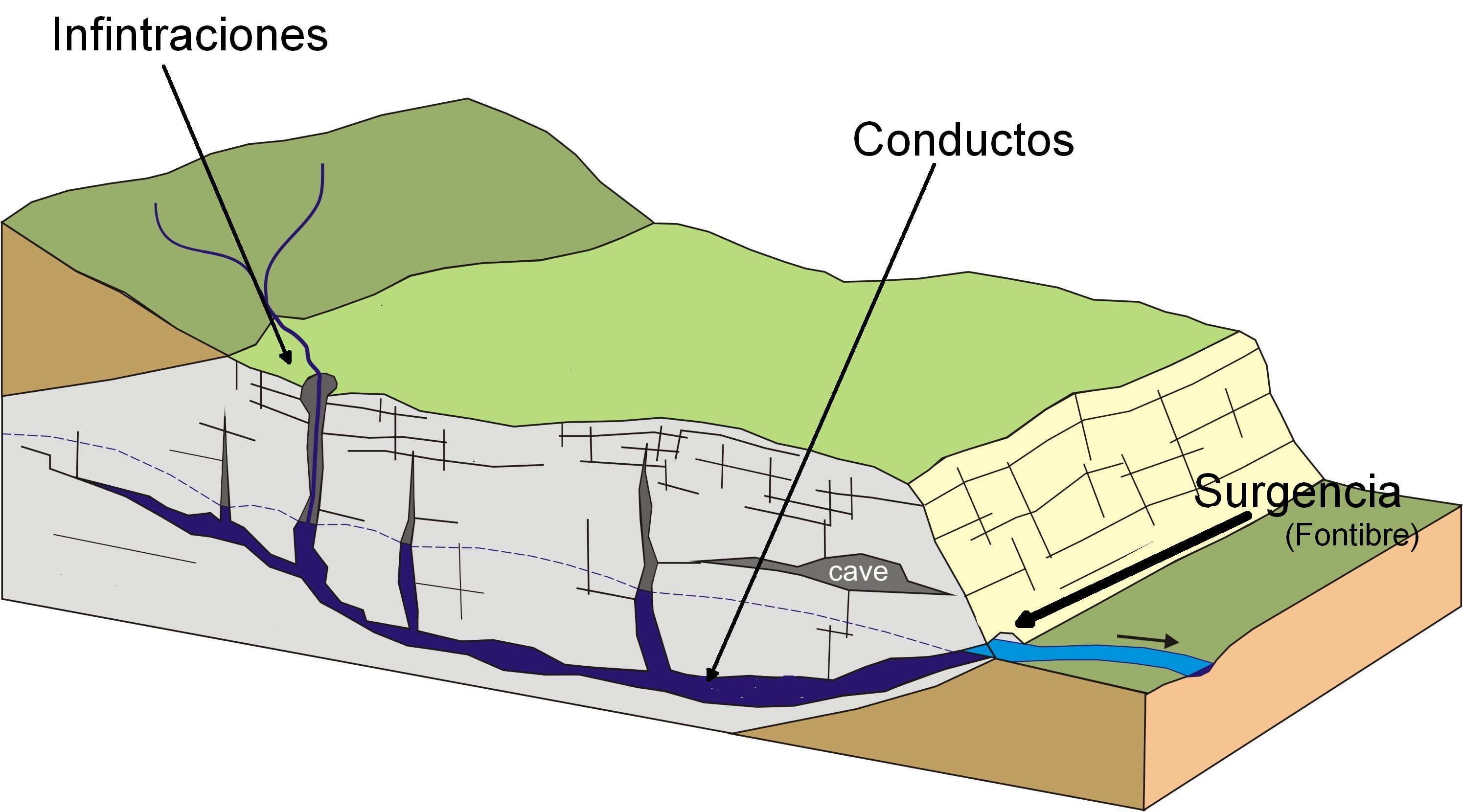
El final río de un sistema subterráneo de drenaje karst, por lo general es una surgencia donde el conducto subterráneo alcanza la superficie. Normalmente se encuentran en un valle erosionado en las rocas de carbonato, las surgencias pueden ser muy cerca del fondo del valle, pero a menudo pueden surgir más arriba del fondo del valle, sobre todo si la erosión del valle ha cortado en rocas impermeables e insolubles bajo el suelo soluble formado por carbonatos. En muchos casos, una cueva puede ser la entrada en una surgencia karst, y otras veces el agua que fluye a partir de la surgencia, sale un agujero demasiado pequeño para admitir a una persona, o el paso está completamente lleno del agua.
Para registrar este earthcache, enviame un correo electrónico con las respuesstas para las siguientes preguntas:
1) ¿Cuales son las dimensiones aproximadas de la surgencia (altura y ancho)?
2) ¿Cual es la orientacion de la surgencia? (N,S,SO, ...) ¿Y la de los 100 primeros metros del Ebro?
3) ¿Cuantos escalones hay que bajar para llegar a la estatua?
4) Añade una fotografia tuya en el local, u otra en la que se pueda ver algún objeto, o tu nick en un papel
- Si piensa que a concluido con exito los objetivos de esta Earthcache y ya me envio todas las respuestas según lo pedido, por favor, proceda a logar el cache como encontrado, despues verificare las respuestas enviadas,y si es necesario, contactare con usted para efectuar las correcciones oportunas a su registro.
-Todos los logs sin respuestas seran apagados sin aviso.
English
The toponym "Fontibre" refers to the birth of the Ebro, since it derives from the Latin “Fontes Iberis” ("Ebro’s Sources")
The birth of the “River Ebro” has located traditionally here, in spite of the fact that, in scientific terms, this is not exact, since it is known that the principal origin of the waters of the river Ebro is the river Híjar. Investigations realized by the Geological and Mining Institute of Spain at 1987, had determined with certainty that Fontibre's spring has its origin in the river Híjar, which born in the circus of “Pico tres Mares”.
So, we will find here a "karst spring", which is considered as the “Source of the Ebro river”
Karst Formations
Karst is a term applied to areas where extensive dissolution of rock has led to the development of subterranean channels through which groundwater flows in conduits (enclosed or semi-enclosed channels). These conduits can vary in size from slightly enlarged cracks to tunnels many meters in diameter and many kilometers in length.
Karst is produced mostly in areas underlain by carbonate rocks, usually limestones and dolostones.
Areas of karst topography are characterized by natural features such as sinkholes, which often are seen as circular ponds or depressions, particularly from the air. Other common karst features are caverns, springs, and few or no continuous surface streams.
The evolution of karst topography differs significantly from more typical landscapes where erosion and deposition by running water sculpt the land surface. In karst topography, the underlying soluble rocks are removed by being dissolved instead of being eroded.
Karst Springs
Groundwater percolating through cracks removes the soluble rock while leaving an enlarged channel for further (and progressively more efficient) flow of water. If there is a thick cover of soil above the soluble rock, surface streams may flow above the subterranean karst drainage system. But more commonly, dissolution features occur at the surface, and hence there are few continuous surface streams because runoff encounters sinkholes or is otherwise routed underground.
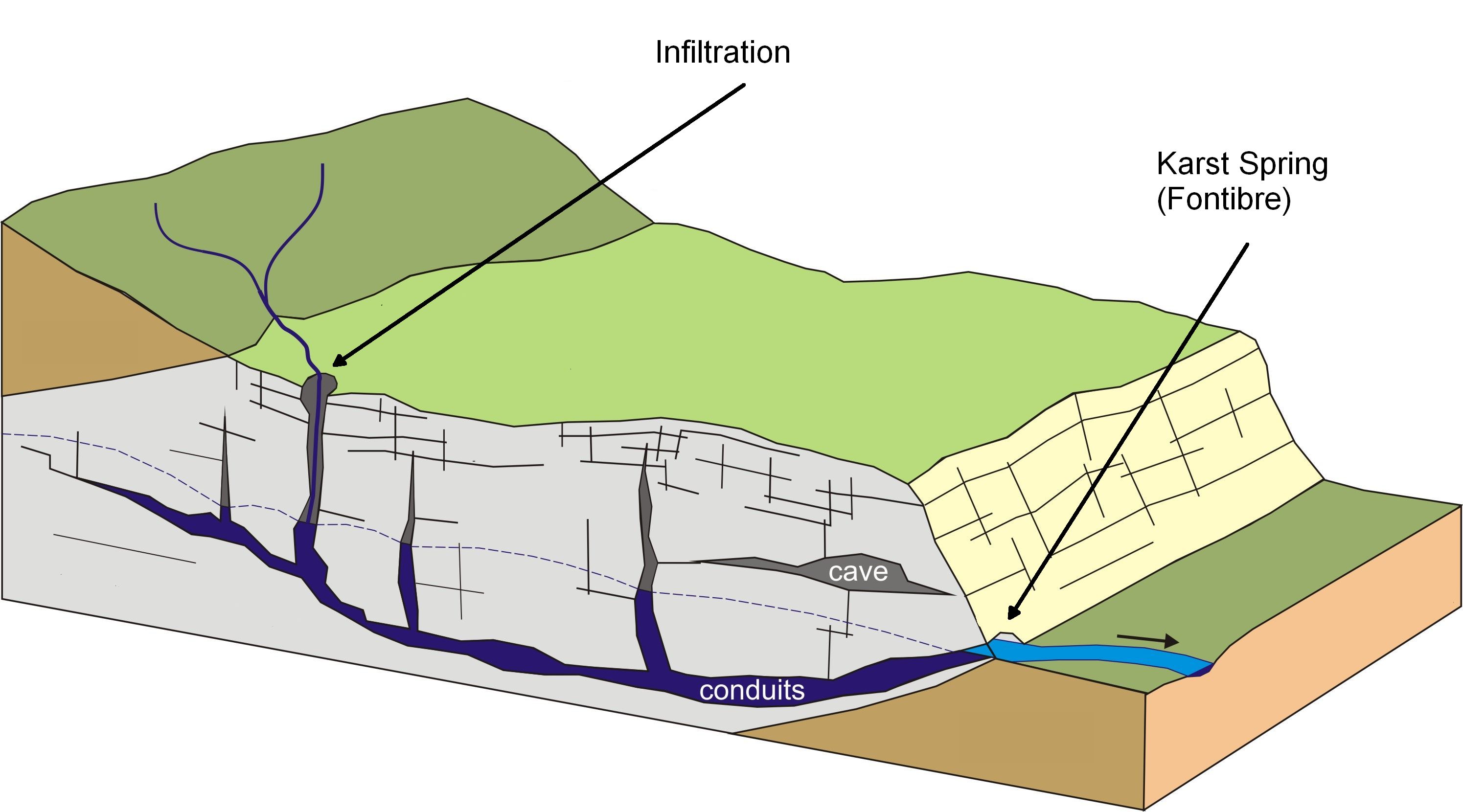
The downstream end of a karst drainage system usually is a spring where the underground conduit reaches the surface. Typically found in a valley eroded into the carbonate rocks, springs may be very close to the valley bottom, but often emerge well above the valley floor, especially if the erosion of the valley has cut into impermeable and insoluble rocks beneath the soluble layers. In many cases, caves may be entered at karst springs, but sometimes either the water flowing from the spring comes out a hole too small to admit a person, or the passage is completely filled with water.
To log this earthcache, send me an email/message with the answer to the following questions:
1) What are the approximate dimensions of spring (height and width)?
2) What is the orientation of spring? (N, S, SO, ...) And the first 100 meters from the River Ebro?
3) How many steps have to go down to get to the statue?
4) Add a photo of yourself at the place, or another in which you can see an object, or your nick on a piece of paper
-If you believe you have successfully completed this Earth Cache goals and has already sent to me all the requirements as requested, Please, feel free to log it as found. Later i will verify the requirements sent and, if necessary, contact you in order to make the necessary corrections to your log.
-Logs without answers, will be deleted without notice.
Sources:
-Wikipedia
-Water encyplopedia |