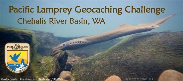
The Pacific Lamprey Geocaching Series will teach you some interesting facts about the Chehalis River Basin and the Pacific Lamprey found there. The Pacific Lamprey (Entosphenus tridentatus), relatively unknown and often underappreciated, is a declining species of fish that is a critical contributor to the fresh and saltwater ecosystems of the Pacific Northwest. These fish are also an important food and cultural resource for many Native American tribes. Threats to Pacific Lamprey include dams, stream degradation, poor water quality, and impacts of climate change. The U.S. Fish and Wildlife Service is working to restore Pacific Lamprey populations in collaboration with Native American tribes and other federal, state, and local agencies.
While there were pathtags for the first 75 cachers to complete the series, the real reward is learning more about the Pacific Lamprey, the Chehalis Basin, and the conservation entities working to restore these and other fish and wildlife populations. We hope that through this series you will develop a greater understanding of and appreciation for these “forgotten fish.”
What is the Pacific Lamprey Geocaching Series? - It is a series of six mystery caches located throughout the Chehalis River Basin. Solve the puzzles for these 6 caches, and then enjoy finding the cache at each location.
How to solve the puzzle and find the cache:
- There are two questions below, one for North coordinates and one for West coordinates.
- Use the provided web links to get the correct answer for each question.
- For the actual cache location use the coordinates given behind the correct answers.
- Find the cache using these coordinates and the hint.
- Park at the coordinates given below as a waypoint.
North coordinates question: What do Pacific Lamprey do after they spawn (reproduce)? (for answer, visit link)
- Head back to the ocean = N 46° 56.328
- Stay on the nest and guard it from predators = N 46° 56.286
- Die shortly afterwards, providing nutrients to other organisms. = N 46° 56.331
- Scientists don't know = N 46° 56.368
West coordinates question: The Chehalis River Council works to conserve and protect the natural resources of the Chehalis River Watershed. This council is ____________ (for answer, visit link)
- Managed by members of a local grassroots environmental non-profit group = W 123° 18.951
- Managed by Grays Harbor County = W 123° 18.863
- Managed by Washington State Department of Natural Resources = W 123° 18.878
- Managed by U.S. Fish and Wildlife Service = W 123° 18.954
For a close up look at why conserving Pacific Lamprey is important, please watch this video link.