DL5 Day Lake
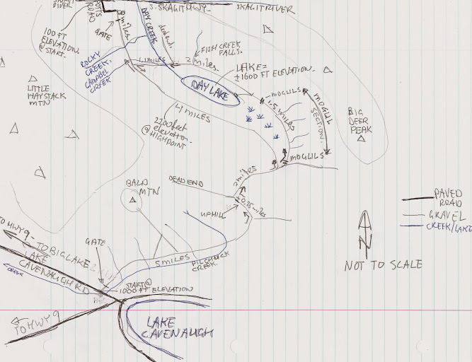
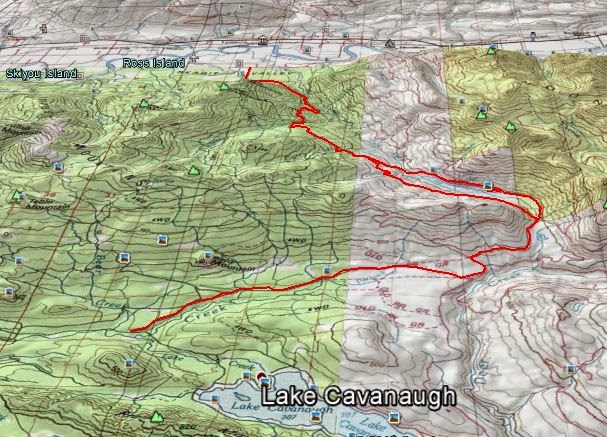
Day lake is a large lake in Skagit County. Not many people have been here. There are several ways in. Two routes are described here. The easiest route starts at Lake Cavanaugh road at about 1000 feet elevation. (10 miles one way) near DL1. The loop around Day lake from Lake Cavanaugh is about 24 miles with 2200 feet as the highest point. From Lake Cavanaugh road to Potts road along the south Skagit highway is about 21-22 miles. There is a gate south of Potts road as well.
These forests are owned by DNR and Weyerhauser –the former Longview Timber Company.
Weyerhauser’s North Cascades Tree Farm is accessible for non-motorized use. No camping, day use only, stay out of active logging areas and no smoking or fires. The area could be closed at any time, sometimes for logging or fire danger.
--Click here-- and check the bottom of the page under Weyerhaeuser Columbia Timberlands/Longview.
Probably best to call the Weyerhaeuser Recreational Access Hotline for Washington before you go at 1-866-636-6531. The information on the phone is often more up to date than the website.
The Lake Cavanaugh route starts at a logging road going uphill from Lake Cavanaugh road. Park across the road and do not block the gate or drive through when it is open. This gate may be locked at any time.
The first short hill is a little steep, but then it is almost level for several miles. Stay on the main road, and don’t take left turns for about 5 miles. This section parallels Pilchuck creek east almost to the source. At about 5.5 miles, take the left fork just past the quarry, uphill. In a quarter mile, turn right near sign 1400. Follow this road 2.0 miles to an intersection with roads coming in from both sides of Day Lake about 500 feet apart near DL4. The old road to the east side of Day Lake is decommissioned with about 25 moguls including 7 small, easy stream crossings. If you follow the road to the east side of Day lake you will see a road forking to the left after 1.5 miles down to the beach and the cache.
After enjoying the lake return to the fork in the road, continue along the road around the lake to Fish Creek falls. This road is in good condition. At the north end of the lake you have the option of returning the way you came (22 miles round trip) or continue the loop around the lake by crossing Day creek and Campbell creek and heading uphill northwest. The road heading north on the east side of day creek is a dead end.
After crossing Day creek and Campbell creek the road goes northwest somewhat steep uphill for 1.1 miles. At the fork in the road at 1.1 miles from the lake, left (south) continues the loop around the lake, back to Lake Cavanaugh road. The logging road to the north continues pretty flat for a few miles and then all the way down to Potts road and the South Skagit Highway for 8 miles total. The route to the Skagit is easy to follow, just follow the main gravel road north.