The Mount Tumulus
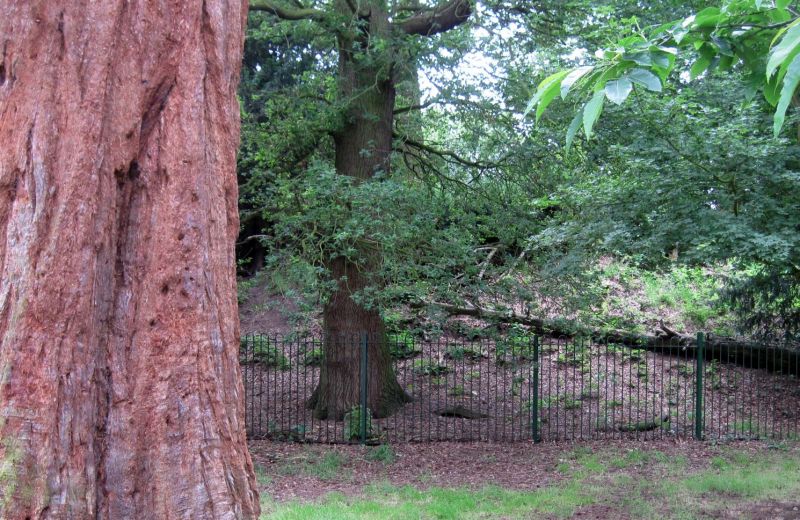
The Earthcache is located in Lexden, on a SSSI that is maintained by Colchester Council. The Tumulus can be accessed via a flat footpath path and grass, suitable for wheelchairs, but please note the tumulus is surrounded by a fence.
The objective of this earthcache is to learn and understand about the soil which surrounds the Tumlus and as a bonus to learn abit about the Tumulus too.
What is a Tumulus:
A tumulus is a mound of earth and stones raised over a grave or graves. Tumuli are also known as barrows, burial mounds, or kurgans. When composed largely or entirely of stones they are usually referred to as cairns. The phenomenon appears early in human history, during the Neolithic era, and although used almost universally tumuli differ in size, structure, and usage with each culture.
In one aspect, the tumulus is a simple way to bury the dead and honor them with a memorial, for it requires little sophistication or technology. On the other hand, though, the size of many of these mounds is impressive by today's standards, and far more so considering the lack of technology available in ancient times. Their appearance throughout the world in unrelated cultures indicates a universal appreciation for the dead members of their society, and a desire to mark their life permanently in the physical world.
This Tumulus:
The Mount, Marlowe Way, Colchester - Was A Romano-Celtic burial mound that belonging to an unknown person, but a very important un known person of the 1st century AD, some fragments of Roman pottery and tiles have been found at the site. Today it is a residential area with a hidden secret most people do not know about.
Now for the Earth-Science
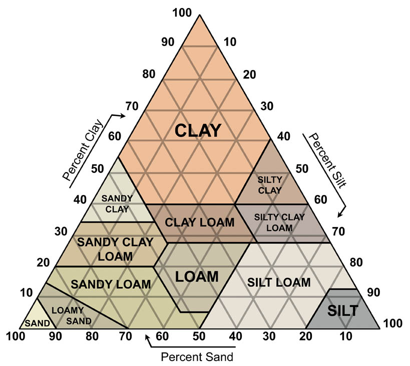
Soil is the uppermost layer of the Earth's surface and is immensely important for life on Earth. It is a mixture of weathered rock fragments and minerals, living organisms, and decaying organic matter called humus, and is the product of several complex and interacting processes. Soil is formed over a long period of time. There are many types of soil, each one reflecting the influence of climate, relief and the underlying geology, as well as the chemical and biological processes involved. Soils are classified according to the national system of the Soil Survey of England and Wales.
The soil types of Essex have helped shape the landscape, wildlife and economy of the County. The boulder clay region of north-west and central Essex has soils which are a rich, crop-producing resource. The London Clay gives rise to less fertile soil and its heavy nature has made arable farming difficult leading to small, dispersed settlements, and an emphasis on pasture. However, the extensive brickearth that overlies the London Clay to the north and east of Colchester form a rich, fertle soil suited particularly to market gardening. Soils developed on the Bagshot Hills, such as the Epping Forest Ridge, are extremely complex with mixed hornbeam/oak woodland on the London Clay and beech on the Claygate Beds.
Much of the surrounding area here covers a high plateau of well drained pebbly gravels, overlaying sands, loams and clays. Impermeable London Clay occurs in the valley bottoms to the south-west, where spring lines and flushes create permanently damp habitats. The conditions vary from dry heath on the plateau, through fertile slopes, to acidic bog in the valleys. 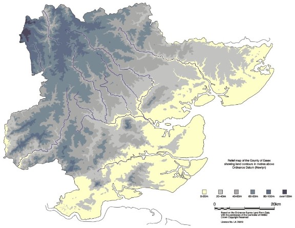
Topographical map of Essex giving a good impression of surface relief. The highest ground is on the chalk downland to the extreme north-west of the county. The lowest land is the flat coastal areas of river alluvium and salt marsh.
To log your visit at this earthcache, please email the answers to the following questions,
1. Observe, and describe, the soil type and colour, which you find at this site? Where does it fit onto the Soil Survey diagram?
2. What would be best the use for this type of soil?
3. Take a photo of yourself in front of the Tumulus. (Not required, but desired)
Remember only estimates are required, YOU CAN NOT WALK ONTO THE MOUND DUE TO BEING ON PRIVATE PROPERTY.