So, once I had actually found it I decided to do a bit of research into it.
The remains of the monument are actually on their side in the river Usk itself but there is one strip of metal railings that originally surrounded it left on top of the bank amoungst the trees (just). Unfortunately it is only a matter of time before this falls into the Usk too I suspect and then evidence of the monument will be all but lost sadly.
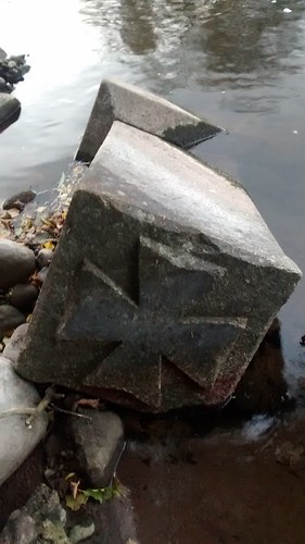
You can still see the monument itself when the water is low but only if you lean out over the banking - which is of course entirely up to you, but I would certainly not let children do this myself! The river, even when low, can be a dangerous place.
The History
It was actually surprisingly hard to find out about this monument! I looked at several old maps online and the monument is recognised on maps back to at least 1885 where it is situated on the inland side of the footpath that runs close to the Usk on the Brookes estate, the forerunner to the Nevill Court (and then Nevill Hall) estate. In fact it appears to remain in this situation for some time but the course of the river seems to have changed slightly at some point and there was probably active erosion under the bank where the monument was sited (but I am only speculating here). Indeed Joseph Bradney (“A History of Monmouthshire” c1910) states: “At the spot called Pwll-cam (the crooked pool) the river is now altering its course in a northerly direction” and that “the large meadow now on the south side was once on the north side of the river”.
The monument itself was probably erected in memory of the drowning of a boy from the Steele family who were prestigious nineteenth century physicians, indeed Mr William Steele used to live at The Brookes until the 1860's. Unfortunately I could not see any inscription or plaque on the sides of the monument that I could access so it seems that this will remain a mystery to me at the moment!
Interestingly just upstream, close to where the small sidestream joins the main river there is the scant remains of some sort of construction that looks to me like some old bridge or pontoon-type base but I can see no historical evidence of what it might have been on any mapping. My only thought is that it might be the remains of the rifle range targets that were here around 1900 and the rest has gone into the river when it eroded the area.
I am grateful to the Abergavenny Museum for their help in researching this.
The Cache
I have deliberately made this an easy multi as I would like to enjoy this spot rather than spend lots of time searching. It was going to be a traditional cache but due to it's proximity to the River Usk (which is protected) I have made it a very easy multi with the cache not too far away. The cache itself is a specimen-type container with just a log in so you will need a pen.
You can approach this from the north (shorter, will take about 20 minutes in total) where there is space for one car, or from the east (a bit further). Whichever way you approach this is a very pleasant, easy walk in lovely countryside, but in my opinion approaching from the east is preferable due to the walk being alongside the river. But please note, whichever way you come there are open drops into the water right next to the footpath at some points and the river can burst it's banks after heavy rain, making the footpath impassable on odd occasions.
Oh, and don't forget to take a look at the view of Blorenge from here as it's a great angle!
The Multi
So, locate the remaining railings and, viewing from the path side (there is no need to go past the railings and get close to the river) answer the questions below and then substitute the answers in the co-ords further down in the normal manner:
How many sides on an individual vertical rail? = A
Count the total number of vertical rails. Take the first digit away form the second to give you B.
How many bars to the right side of the left-hand tree. Add the two digits of the number together to give you C.
Look at the third rail from the right closely. If it is a rounded bar in a square hole, D=4. If it a square bar in a round hole, D=3
How many horizontal rails? = E
How many of the vertical bars are embedded in the left tree? = F
Got the answers? Good! Then stick them in this and off you go, N 51° 49.ABC W 003° 02.(D-E)(B+E)(C+F)
As usual, please replace the cache out of sight.