 This EarthCache is listed with permission of the owner of the nearby cache Shake Your Booty that has some great information about the earthquake.
This is the approximate location of the epicenter of the Loma Prieta Earthquake. This earthquake occurred October 17, 1989 - 5:04 pm local time and had a local magnitude of 6.9 and a surface-wave magnitude of 7.1. The epicenter of the earthquake was at 37.036N 121.883W with the hypocenter 19 km below that. The rupture surface was along about 35 km of a dipping fault plane.
There are a lot of geological terms in the above statement, so what do all those terms used to describe the earthquake mean?
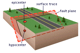
 Epicenter: The epicenter of an earthquake is the point on the surface of the earth directly above the point inside the earth where the earthquake movement begins. You are standing at the epicenter.
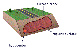
Hypocenter: That point where earthquake movement begins is called the hypocenter or focus. In the case of the Loma Prieta Earthquake, the focus was 19 kilometers (~11.8 miles) below you.
Fault Plane: The flat surface of a fault extending in all directions, up, down, and in both directions. Where the fault plane reaches the surface of the ground, that is the surface trace of the fault.
 Rupture Surface: That portion of the fault plane that moves during an earthquake. Note that the entire fault does not move, just a small portion of it.
Local Magnitude: This is one of a few methods for determining the relative size of an earthquake based on the maximum movement on a seismograph and the distance to the hypocenter. This method is commonly referred to as the Richter scale. This scale is designed for measuring earthquakes up to 600 km away.
Surface-wave Magnitude: The is method of determining the relative size of an earthquake also is based on the maximum movement on a seismograph and the distance to the hypocenter. However this scale can be applied to earthquakes from around the world. This scale was designed so that it will return a similar value as the local magnitude.
Earthquakes are typically named after a local town or geographic feature near the epicenter, not the fault that moved. This is because the surface trace of the fault that moved could be many kilometers away depending upon the angle of the fault plane.
Logging questions:
- The text "GC5Q4J1 Loma Prieta Earthquake Epicenter" on the first line.
- The number of people in your group.
- The sign marking the epicenter provides coordinates for the epicenter. How far off and in what direction is the actual epicenter as provided in the description?
- Since this is the epicenter of the earthquake why isn't the fault trace visible?
- Using the earthquake naming convention above, propose another name for this earthquake.
The following sources were used to generate this cache:
- The Loma Prieta, California, Earthquake of October 17, 1989
- http://earthquake.usgs.gov/learn/glossary/?term=fault%20plane
- http://scedc.caltech.edu/Module/sec1pg06.html