
Devil's Backbone Park is located along Route #68 near Lappan's Crossroads. To access the park from the Sharpsburg Pike, Route #65, turn left at Lappan's Crossroads and continue approximately one and one-half miles on Route #68 toward Boonsboro. The park is on the left.
Opened to the public on June 26, 1966, Devil's Backbone is the second oldest of Washington County's parks. This nine acre park includes a footbridge across the Antietam Creek, which divides the park, providing access to the "island" section of the park as well as to a nature trail which ascends to the summit of the ridge from which the park takes its name. The park also offers fishing and an access for canoes to the Antietam Creek.
Parking is limited to 38 vehicles.
Although officially open from the first Saturday in May through the last Sunday in October, from 9:00 AM until sunset; walk-in access is permitted year-round.
Local geology:
The dam located here has been in place since the 1820’s and there use to be a flour mill that used the water to turn its wheels. The dam has been helping to control the Antietam creek during flood periods and has helped tame the erosional power of the creek here. The devils backbone ridge comes to a point where the erosion is the greatest at the confluence of the Antietam and beaver creek. The high point of the ridge is 512 feet above sea level where as the area along the creek has an elevation of 360 feet above sea level. Yes the Devils backbone is over 150 feet high and very old. Erosion between these two creeks has carved this ridge over time and has created this scenic area for you to enjoy.

Physiographic region:
The Ridge and Valley Province between South Mountain in Washington County and Dans Mountain in western Allegany County contains strongly folded and faulted sedimentary rocks. In the eastern part of the region, a wide, open valley called the Great Valley, or in Maryland, the Hagerstown Valley, is formed on Cambrian and Ordovician limestone and dolomite.
This valley is actually part of the much larger Great Appalachian Valley. It is a gigantic trough—a chain of valley lowlands—and the central feature of the Appalachian Mountain system. The trough stretches about 1,200 miles from Quebec to Alabama and has been an important north-south route of travel since prehistoric times.

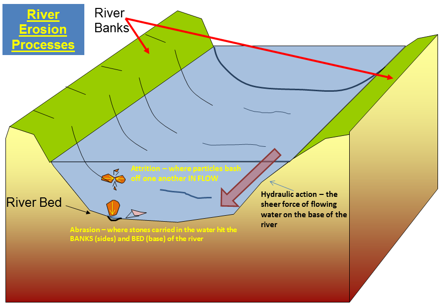
Erosion
Erosion is the process by which soil and rock are removed from the Earth's surface by natural processes such as wind or water flow, and then transported and deposited in other locations.
Types of Erosion:
Splash Erosion: Small soil particles are detached and sent airborne through the impact of raindrops on soil.
Sheet Erosion: Raindrops break apart the soil structure and it's moved down-slope by water that flows overland as a sheet rather than definitive channels. This occurs frequently during cloud bursts.
Rill Erosion: This process develops small, short-lived, concentrated flow paths. These paths create a sediment source and delivery system for hill-slope erosion. Areas where precipitation rates exceed soil infiltration rates are more prone to this type of erosion.
Gully Erosion: Water flows in narrow channels during or directly following heavy rains or melting snow. The gullies can erode to considerable depths.
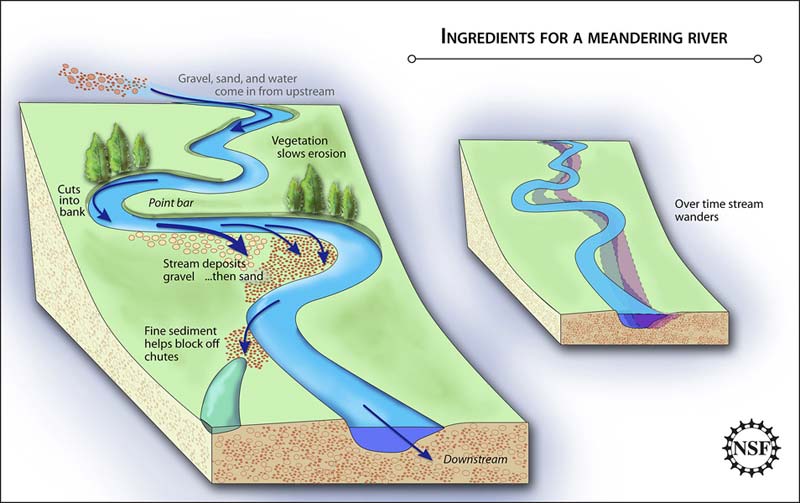
Valley or Stream Erosion: Continual water flow alongside land (along a linear feature) creates this type of erosion. It extends downward, deepening a valley, and head-ward, extending the valley into the hillside. This occurs most frequently in times of flooding.
Bank Erosion: Over time, banks of rivers and streams are naturally worn down.
Freezing and thawing: Cold weather causes water trapped in tiny rock cracks to freeze and expand, breaking the rock into several pieces.
Deposits
As rivers carry dust, pebbles, and rocks downstream, this material is eventually deposited at some locations further down. These deposits form at bends in a river, as well as in locations where rivers dump water into lakes.
**Logging requirements**
DO NOT POST ANSWERS IN YOUR LOG.
Send the following answers to me via email.
- The text "GC5Q6T7 Devil's Backbone Park" on the first line
- How wide is the river at the walk bridge?
- Drop a leaf or stick in the creek and estimate how fast the erosinal force of the creek is flowing today.
- What is the major material that lines the banks below the dam? (A=Mud, B=Concrete, C=Rock, D=steel walls)