Abberley and Malvern Hills Geopark and the Geopark Way
The Abberley and Malvern Hills Geopark was created in October 2003 as the 17th member of the European Geopark Network, a UNESCO-led initiative, intended to promote areas having special geological features. The park covers an area of nearly 500 square miles within the counties of Shropshire, Worcestershire, Herefordshire and Gloucestershire. The two lines of the Abberley and Malvern hills form the backbone of the Geopark, representing over 500 million years of Earth history, spanning from Precambrian to Jurassic, including almost complete successions from the Silurian and Triassic periods.

The Geopark Way is the brain-child of the Herefordshire and Worcestershire Earth Heritage Trust, a charity that aims to record, protect and promote geology and landscape. The trust has worked together with local landowners to develop the Geopark Way into a long distance landscape and geology walking trail through the Geopark. The trail provides a meandering route of some 109 miles from Bridgnorth to Gloucester, linking the many important geological sites contained within the Geopark. The HWEHT publish a printed guide to the trail and have also produced a series of smartphone apps for use along the walk. You will find the site of this earthcache and the walk out to it covered in part 5 (Bewdley to Larford Lake).
Redstone Rock and Hermitage
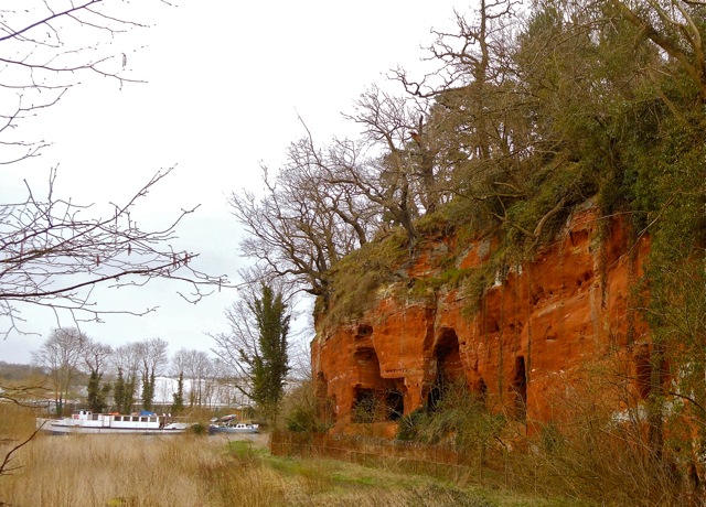
Redstone Rock once occupied an important position in the local geography. Before the building of Stourport Bridge in 1775, followed by the construction of the Lincomb Weir and dredging of the river to allow navigation to the Stourport canal locks, the Severn at this location used to flow wide and shallow. The site offered one of the few locations where the river could be forded, making it an important crossing point; from Roman times onwards, Redstone Crossing formed part of the old main road between London and Wales. At times when the river was running too high for the ford to be safely used, a ferry carried traffic across the river.

The soft sandstone of Redstone Rock is easily carved and there is evidence of human-made habitation in the cliff face since Stone Age times. The caves that can be seen today were mostly made in the 12th century, when a hermitage was established there, conveniently located for the hermits to be on hand to offer blessings and prayers for passers-by in return for alms. The caves were later used as domestic dwellings and were inhabited almost continuously until the mid twentieth century.
Permian and Triassic times in Worcestershire
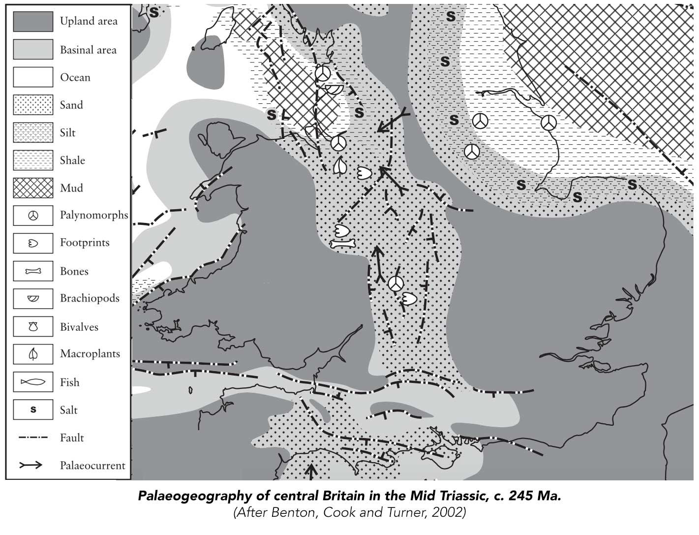
Within the Geopark, the Permian (300-250 Ma) is marked by the onset of the subsidence of the Worcester Basin, or Graben. The climate in the region was hot and arid, the land being principally sandy desert upland. At that time, most of the Earth's landmass still made up a single supercontinent known to geologists as Pangaea, which straddled the equator and extended toward the poles. During the Triassic Period (250-200 Ma), Pangaea was beginning to rift and break apart; as a result the climate changed to became more humid as this area of the land drifted into the subtropics. Flash floods and rivers started to invade the previously desert landscape, creating what today we see as the thick layers of Triassic sandstones. Near the end of the Triassic there was a marked change from the terrestrial environments that characterised Triassic deposition into shallow marine shelf environments as a global rise in sea level caused the low-lying area of the Worcester Basin to be inundated by the sea.
Throughout the Triassic, there was steady transport of Permian dune sands northwards in a complex and extensive fluvial system which stretched from south Devon through the central Midlands to the Cheshire Basin.

The Wildmoor Formation
The abandoned river bank of Redstone Rock consists of deposits of the Wildmoor Sandstone Formation, which dates from early in the Anisian Age (approx 247-242 Ma) of the Mid Triassic. The formation intersperses iron-oxide stained red sandstone layers with much paler and broken layers of brecciated siltstones, mudstones and evaporite deposits and is generally attributed to flash-flood and braided stream settings, with periodic brackish inundation. Before a systematic renaming of British Permian and Triassic sandstones in the 1980s, this rock was known by the more descriptive name of Upper Mottled Sandstone.
The Earthcache
The published coordinates are easily reached along the Geopark Way, which approaches along the western bank of the River Severn from a flight of steps at the Areley Kings end of Stourport Bridge on the A451 (Bridge Street).
WARNING: The riverside path will be submerged and impassible when the Severn is in flood. Check water levels before setting off.
Redstone Rock, with its old hermitage caves, comes into view once you have wound your way past the end of the caravan park.
WARNING: Do not attempt to enter the caves themselves, whatever the conditions. The caves are nowadays in a dangerous state and access to them is prevented by a high fence, topped with razor wire.
Easy and safe access to the rock face to observe the geology at close quarters can be made at Waypoint 1 (but BEWARE: this location is close to unfenced river bank and you will need to keep a close eye on any children in the party — or, indeed, anyone else who may be prone to falling into water!)
Waypoint 2 also offers a close-up point of access, where one of the smaller caves is safe to enter, although you may need to fight the brambles to get there!
To claim this earthcache: email us with your answers to the following questions:
- The cliff consists mainly of red sandstone interspersed with distinctly contrasting horizontal bands of siltstone and evaporite beds. Describe the colours of these contrasting beds at Waypoint 1. What range of thicknesses do these bands display in this part of the cliff?
- Estimate what proportion of this section of the cliff face is composed of material other than red sandstone. How does this compare with the face of the cliff as a whole?
- Are the contrasting siltstone and evaporite inclusions harder or softer than the surrounding sandstone? How have you reached this conclusion? Why do you think this might be?
- What evidence can you see at either waypoint that these deposits were laid down within a fluvial flash-flood or braided stream environment?
Once you have emailed your answers, there is no need to wait for confirmation that you are correct before logging. If you prefer to log your finds in the field and email later, please ensure that your log indicates clearly when we can expect your answers. Logs for which no answers have been received may be deleted without warning unless we know to expect them later. Your log should not include any answers, or photographs which reveal the answers.
This earthcache description uses information obtained from:
- Herefordshire and Worcestershire Earth Heritage Trust (2009), The Geopark Way ISBN: 978-0-9558390-0-9
- Benton, M., Cook, E. & Turner, P., (2002), Permian and Triassic Red Beds and the Penarth Group of Great Britain, Geological Conservation Review Series, No. 24, Joint Nature Conservation Committee, Peterborough, 337 pages, illustrations, A4 hardback, ISBN 1 86107 493 X