Gole Alcantara

Italiano
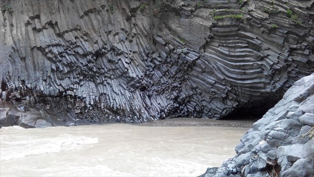
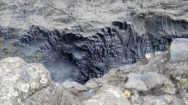
In tempi remotissimi (Terziario) vi fu una eruzione dal vulcano di Moio Alcantara, alle falde dell` Etna, talmente copiosa da invadere tutto il territorio oggi bagnato dal fiume Alcantara, dal monte al mare (a Naxos). Durante la fase di consolidamento del magma si verifico in questo punto un misterioso fenomeno che sconvolse la compattezza della grand massa, strutturandola , per effetto delle forze crisalline che in essa operearono in un infinita die prismi netti e geometricamente perfetti
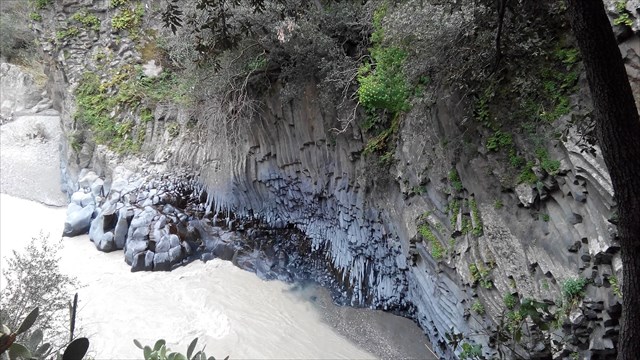
Tutto il materiale roccioso del canyon costituito da roccia lavica. Lava basaltica è il minerale predominante, che è ricca di ferro e magnesio e calcio.La pietra è basso in silicone. Il pilastro pentagonali ed esagonali prismatico emersa in un processo di lento raffreddori del flusso di lava.
Le gole hanno una larghezza media di 5 m, l'altezza è di 50 m, mentre la lunghezza di 400 m, di cui solo una parte di essa è ancora accessibile. Il fiume Alcantara nasce sull'Etna a quota 1250 m, aggira le pendici settentrionali del vulcano e sfocia nel Mar Ionio a Naxos, dopo un percorso di 48 km. Le sue abbondanti riserve d'acqua di due centrali idroelettriche nelle vicinanze delle gole e rende la valle dello stesso Randazzo e Taormina fertile e rigogliosa.
Il letto del fiume è realizzato interamente in pietra lavica, il disegno di che provoca un flusso irregolare di acqua, che a volte lento (formazione di piccoli laghi) flussi talvolta impetuose cascate (viaggiando). Queste bellezze non sono facili da vedere, perché il flusso nella parte più interessante attraverso le zone di massima e quasi inaccessibili flussi; il letto del fiume attraverso voragini e fenditure di lava.
Dirigetevi verso il punto N 37 52 752 / E 15 10.481
Rispondi alle seguenti domande.
1. Che tipo di erosione è descritto sulla carta ?
2. Descrivere 3 tipi di formazioni di basalto che si possono vedere nella gola! (domanda opzionale)
Risposta 2 si possono trovare a N 37 52.818 / E 15 10.452
English
A very long time ago (Tertiary period) there was an eruption of Etna so abundant that it covered the whole territory today bathed by the Alcantara river, from mountain to sea. During the consolidation phase of the magma, at this point a mysterious phenomen occurred which ruined the compactness of the great mass, moulding it, due to the crystalline forces operating within it, into an infinity of Prisms clearcut and geometrically perfect.
The whole rock material of the canyon consists of lava rock. Basaltic lava is the predominant mineral which is rich in iron and magnesium and calcium.Silizium is not as dominant as the other minerals.The prismatic pentagonal and hexagonal pillar emerged in a process of slow colds of the lava flow .
lf today we can enter this mass and admire terrified this agglomeration of stupifying prisms this is due to the erosive action of the Alcantara river, which, in the arc of the thousands of years of excavation in the very hard basalt, has created this fearsome, suggestive gorge.
The average width of the Gorges is 5 metres, their height exceeds 50 metres and they are 400 metres in length of which only a part in accessible today.
The Alcantara river rises from Etna at a height of 1250 metres, flanks the northern slopes ofthe volcano and, after a course of 48 Km., flows into the Ionian, at Naxos. Besides feeding two hydro-electric power stations near the Gorges, its generous waters make the valley of the same name from Randazzo to Taormina fertile and fruitful. This river’s bed is completely composed of lavic rock whose conformation causes irregular flow of the waters, which are sometimes calm (with enchanting small lakes) and sometimes violent (with stupendous waterfalls).
Go to the Position N 37 52.752 / E 15 10.481
Please answer the following Questions.You are allowed to log the Cache immediatly.If there is something wrong i will contact you.
1. What kind of erosion is shown and descibed on th panel?
2. Describe 3 kinds of basaltformation you can see here in the gorge! (optional Question)
Answer 2 you find at Position N 37 52.818 / E 15 10.452
German
In sehr alten Zeiten (Tertiär) überdeckte ein ausgiebiger Ausbruch des Etna das ganze Gebiet, das heute vom Fluss Alcantara vom Berg bis zum Meer benetzt wird. Während der Erhärtungsphase des Magma ereignete sich in diesem Punkt ein seltsames Phänomen, das die Festigkeit der grossen Masse umwälzte und sie durch den Effekt der Kristallkräfte, die in ihr wohnten, in eine Unzähligkeit von klar abgeschnittenen und geometrisch perfekten Prismen strukturierte.
Das gesamte Gesteinsmaterial der Schlucht besteht aus Lavagestein. Basaltische Lava ist das vorherrschende Mineral welches reich an Eisen sowie Magnesium und Calcium ist.Das Gestein ist eher Siliziumarm. Die prismatischen fünf- und sechseckigen Säule entstanden in einem Prozeß der langsamen Erkaltung des Lavastroms.
Die Schluchten haben eine mittlere Weite von 5 m, die Höhe beträgt etwa 50 m, während die Länge um die 400 m ist, von der heute nur noch ein Teil davon zugänglich ist. Der Alcantara-Fluss entspringt auf dem Etna auf einer Höhe von 1250 m, umgeht die Nordhänge des Vulkans und mündet im Jonischen Meer bei Naxos nach einem Lauf von 48 Km. Sein reichliches Wasser speist zwei Wasserkraftwerke in der Nähe der Schluchten und macht das gleichnamige Tal von Randazzo bis nach Taormina fruchtbar und üppig.
Das Flussbett ist ganz aus Lavagestein, dessen Gestaltung einen unregelmässigen Durchfluss des Wassers verursacht, welches teils langsam (Bildung kleiner Seen) teils ungestüm fliesst (reissende Wasserfälle). Diese Schönheiten sind leider nicht leicht zu sehen, da der Fluss im interessantesten Teil durch unwegsame und fast unzugängliche Zonen fliesst. Das Flussbett führt durch Abgründe und Klüfte aus Lava.
Begib dich zum Punkt N 37 52.752 / E 15 10.481
Beantworte folgende Fragen um den Cache zu loggen.Du darfst sofort loggen, sollten Unklarheiten bestehen werde ich dich kontaktieren.
1. Welche Art von Erosion ist auf der Schautafel beschrieben?
2. Beschreibe 3 Arten von Basaltformationen die man in der Schlucht sehen kann! (optionale Frage)
Antwort 2 findest du bei N 37 52.818 / E 15 10.452