Plusieurs caches ont été placées sur ce circuit de la boucle du Vauclin. Bien suivre les instructions pour parfaire ce parcours qui par mesure de sécurité est préférable en groupe ou au moins à deux.
Several Caches were placed on this circuit of the Boucle du Vauclin. Well follow the instructions to perfect this route which by security measure is preferable in a group or at least for two.
CACHE N°4
LA DIRECTION :
Sur la route principale entre Le Vauclin et Le François (RN6), en direction du nord juste après Le Vauclin il y a un rond-point où est indiqué le quartier Château Paille sur la droite ( voir way point ci-dessous ). Ensuite il suffit de suivre les panneaux « circuit de la boucle du Vauclin » jusqu'au parking ( voir way point ci-dessous ) au pied d'un grand pylône et juste en face de l'entrée du centre UCPA du Vauclin dédié aux sports nautiques.
LE SITE :
Le circuit ressemble un peu à la randonnée de presqu'île de La Caravelle, mélant plages sauvages, végétation sèche et mangrove. A des points de vue exceptionnels sur les fonds blancs du Vauclin, à faire absolument sous le soleil pour profiter des couleurs...
A voir : Forêt du littoral, faune et flore du secteur, large panorama de la face Est jusqu'à la presqu'île de la Caravelle, îlet Petite Grenade, succession d'Anses, chaines des Îlets du François et du Robert.
-Départ de la randonnée devant le panneau descriptif du circuit près de l'UCPA – Château Paille – Anse Simon – Anse Balahou – Anse Maroquet – Pointe du Vauclin – Trou Cochon – Baie de Petite Grenade en longeant sa Mangrove ,Ferme MARJOLAIT, Petite Grenade retour château Paille.
Une marche de 3 heures environ + temps de recherche des caches.
Avec une distance de 6,500 Kms.
Altitude de 162 mètres.
Attention : Risque de boue par endroit en temps de pluie ou risque d'insolation par beau temps.
A savoir impérativement : Tenue légère, bonnes chaussures de randonnée, pas de vêtement noir, casquette ou chapeau, prévoir linges de rechange crème et lunette solaire, Sac à dos de randonnée, gourde d’eau 1,5 litre, appareil photos et effets personnels, médicaments etc.…
LA CACHE :
Pour ce N°4, la cache de taille moyenne est placée à quelques mètres de la mer. Faîtes preuve d'une grande discrétion car les lieux sont assez fréquentés. SVP remettez bien la cache à sa place d'origine.
____________________________
THE DIRECTION :
On the main road between Vauclin and François ( RN6), in the direction of the North just after Vauclin there is a traffic circle where is indicated the district Chateau Paille on the right ( see way point below ). Then it is enough to follow panels(signs) " circuit de la boucle de Vauclin " up to the parking lot ( see way point below ) at the foot of a big pylon and a just man in front of the entrance of the center UCPA of Vauclin dedicated to water sports.
THE SITE :
The circuit looks like a little the ride of peninsula of The Caravelle, the mélant wild beaches, vegetation dries and mangrove swamp. With in bonus of the exceptional points of view on funds white with the Vauclin, to make absolutely under the sun to take advantage of colors...
- You can see : forest of the coast, the flora and fauna of the sector, the wide panorama of the face is to the peninsula of the Caravelle, îlet Small Grenade, succession of Anses, chains of Îlets du François and Robert.
- Departure of the hike in front of the descriptive panel of the circuit near the UCPA - Chateau Paille- Anse Simon - Anse Balahou - Anse Maroquet - Point of Vauclin - Dirty Hole - Bay of Small Grenade by following its Mangrove swamp - Firm MARJOLAIT, Small Grenade return Chateau Paille.
The walking is : approximately 3 hours + time of search for caches.
With a distance of 6,500 km
And Altitude of 162 meters.
Attention : risk of mud by place in times of rain or risk d'insolation in good weather.
Must be with you : light Clothes, good hiking boots, no black garment, cap or hat, plan spare sets of clothes cream and solar glasses, Backpack of hike, gourd of water 1,5 liters, camera and personal effects, medicine etc. …
THE CACHE :
For this N°4, the medium-sized hiding place is placed a few meters away from the sea. Summits proof of a big discretion because places are frequented enough. PLEASE put back please, the hiding place to its place of origin.
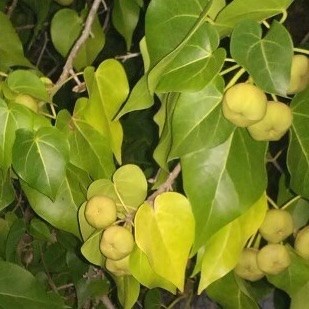
- IMPORTANT: NE VOUS APPROCHEZ PAS DE CERTAINS ARBRES TOXIQUES COMME LE "MANCENILLIER" AINSI QUE LEURS FRUITS.
- IMPORTANT: DO NOT APPROACH CERTAIN TOXIC TREES AS THE "MANCENILLIER" AS WELL AS THEIR FRUITS.

____________________
Contenu original:
- Log et quelques petits trésors habituels.
- TB - CLUSTER FCUK - TB5H1PW
- Crayon
- Pin FTF
Original Content:
- Log and the usual little treasures.
- TB - CLUSTER FCUK - TB5H1PW
- Pencil
- FTF Pin