Ao Phang Nga National Park
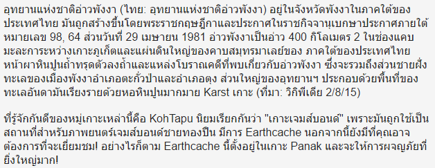
Ao Phang Nga National Park (Thai: อุทยานแห่งชาติอ่าวพังงา) is in Phang Nga Province in southern Thailand. It was created by royal decree and announced in the Royal Gazette under proclamation number 98, section 64 of 29 April 1981. Phang Nga Bay is a 400 km2 bay in the Strait of Malacca between the island of Phuket and the mainland of the Malay peninsula of southern Thailand. Limestone cliffs with caves, collapsed cave systems, and archaeological sites are found about Phang Nga Bay. It includes coastal sections of Muang Phangnga District and Takua Tung District. Most of the park consists of an area of the Andaman Sea studded with numerous limestone tower karst islands. (Source: Wikipedia 2/8/15)
The best known of these islands is KohTapu, popularly called "James Bond Island" because it was used as a location for the James Bond movie The Man with the Golden Gun. There's an Earthcache there also that you might like to also visit! However, this Earthcache is based in Koh Panak and will provide a much great adventure!
Geology of Hongs
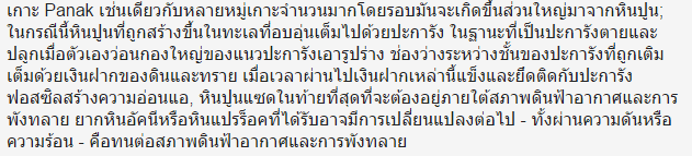
Koh Panak, as are the many, many islands surrounding it, is largely formed of limestone; in this case the limestone was formed in the warm seas filled with coral. As the coral died and regrew upon itself en masse, large mounds of coral reef took shape. The gaps between the layers of coral were filled by deposits of clay and sand. Over time, these deposits hardened and adhered to the fossilising coral forming a weak, stratified limestone that would ultimately be subjected to weathering and erosion. Harder igneous or metamorphic rock, that has been subjected to further change - either through pressure or heat - is more resistant to weathering and erosion.

The general area of Phang Nga bay was subjected to tectonic movements and sections of the seabed were subjected to uplift leaving areas of the seabed raised above the waterline.


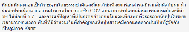
Limestone, a sedimentary rock, is faulted by its nature and is prone to chemical weathering if exposed to rain. Unpolluted rainwater, due to its ability to absorb CO2 from the air, forms mild Carbonic Acid typically has a pH of no less that 5.7 - and this mildly acidic solution is sufficient to dissolve limestone over a long period of time. Areas with significant amounts of chemical-weathered limestone are known as Karst regions.

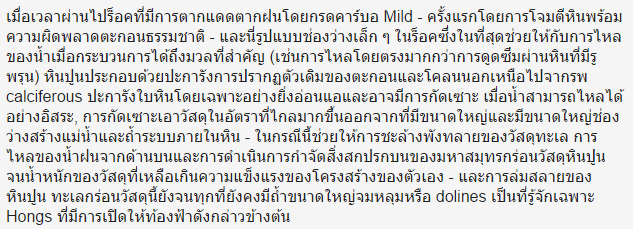
Over time, the rock is weathered by the mild carbonic acid - initially by attacking the rock along its natural sedimentary faults - and this forms small gaps in the rock which, ultimately, assists with the flow of water once the process has reached a critical mass (i.e. direct flow rather than osmosis through the porous rock). In limestone composed of coral, the original presence of silt and mud, in addition to the calciferous exoskeleton of the coral, leaves the rock particularly weak and subject to erosion. Once water is able to flow freely, erosion removes material at a far greater rate leaving larger and larger gaps creating river and cave systems within the rock - in this case allowing erosion of material to the sea. The flow of rainwater from above and the scouring action of the ocean erodes the limestone material until the weight of the remaining material exceeds its own structural strength - and the limestone collapses. The sea erodes this material also until all that remains are large caverns, sink holes or dolines, known locally as hongs, that are open to the skies above. This is where you will visit.

Koh Panak has numerous enormous hongs, several that are accessible at low tide, but impossible to access at high tide. It s the tidal nature of the water flow that removes the material so efficiently.
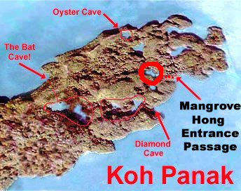
Each cave on Koh Panak has its own characteristics - and the Mangrove Cave is so called for a very obvious reason:


The Earthcache
In order to log this Earthcache, you must go to the listed coordinates, locate the tidal cave and tunnel system, follow it for approximately 60-80 in your kayak until you emerge in the hong in the interior of the island - when you see the mangrove trees, you have arrived. Please note, the earthcache is in the centre of the island, not at the listed coordinates - given the height of the interior hong walls and the small space being visited, it is impossible to get a reliable GPSr reading. You will need to observe and interact with the geology, answer some simple questions and send them to me via the Geocaching Message Centre. You do not have to wait to log your find, but if you fail to contact me with answers, or if there is a difficulty with your answers, the usual caveats apply - I reserve the right to request clarification or to delete your log at my discretion! Earthcaches are not virtuals and internet generated answers are not welcome.
- What kind of rock is the main composition of Koh Panak?
- Is it sedimentary or igneous - and why is this significant in hong formation?
- Is the bed of the main chamber of the hong composed of muddy or sandy material. Speculate as to why this is so.
- Standing inside the Mangrove hong, in the interior of the island, how high is the opening of the tunnel back to the sea?

Leave No Trace
|

|
The cache has been placed in accordance with the "Leave No Trace" principles. Please respect these principles when visiting Ao Phang Nga National Park and when Geocaching at home.

|
