NOTE: This is an earthcache, there is no physical container to find at the coordinates. To get your smiley for the cache, e-mail your answers for the questions below to the cache owner. When answering the questions do your best. It is more important that you learn a new concept about our earth and can apply your knowledge rather than have a precise answer.
Questions:
1-Looking at Skagway Valley and mountains that surround it, explain how can you identify the 2 big periods of glaciations?
2-Look to the south across the Lynn Canal and identify the Harding glacier. Describe the glacier.
3-What effect do you believe rebounding in Skagway has on the stability of the earth in this area?
This Earthcache is located in Skagway Centennial Park. This public park is open 24 hours a day, 7 days a week. Thank you for placement permission from the Skagway Convention and Visitors Bureau.

Welcome to Skagway Alaska, the gateway to the Klondike! In addition to its Gold Rush history, Skagway’s geologic history tells an interesting story.
Tectonic plates form the land:
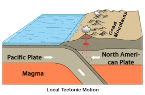
Our story begins with tectonic plates. There are 15 major tectonic plates throughout the world. Where plates meet, depending on how they are moving when they meet, they cause: uplifting (mountains), faulting (earthquakes), and/or magma injections (volcanoes).
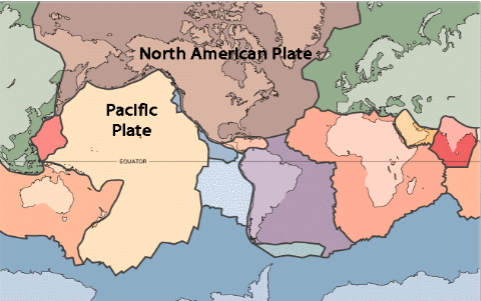
Here in Skagway, the thinner Pacific Plate is being driven beneath the thicker North American plate. Not only are the plates smashing straight together, they are also rotating counterclockwise in this area.
Glaciers reform land:
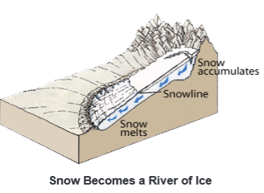
As tectonic plates are acting in depths beneath the surface, the atmosphere is acting on the surface to reform the land. Here in Skagway, erosion and weathering in the form of glaciers break down the mountains that were formed by the smashing plates. Glaciers form at high, cold altitudes where snow collects faster than it can melt. The weight of increasing layers of snow compacts the older layers of snow into ice. Due to gravity, this huge snow and ice mass begins to slide downhill and as this river of ice moves, it carves valleys through mountains.
Skagway Bound:
Although Skagway has been formed by glaciers advancing and retreating over a millennia, only the three most recent periods of glaciation are visible here today.
1) One glaciation happened about 49,000 years ago. The ice carved a U shaped valley through Skagway which included the Lynn Canal. The Lynn Canal currently is filled with water. It is over 100 miles long and 1700 feet deep and is the longest and deepest fjord in North America
2) A second visible glaciation happened between 24,000 – 13,000 years ago when a glacier came through the first carved U and made a smaller shaped U into the existing valley floor.
3) A third visible little ice age glaciation happened between 1500 – 250 years ago when small glaciers formed at high altitudes. The Harding Glacier is from this time period.
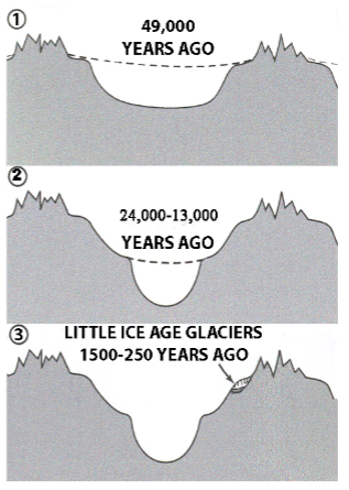
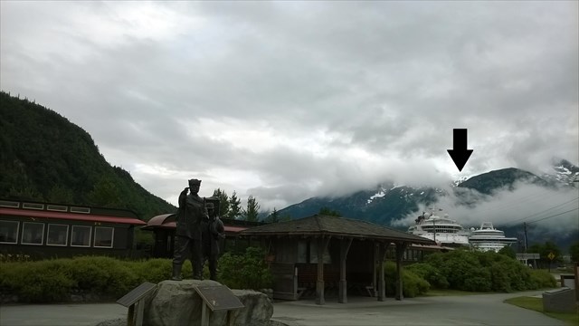
The Harding glacier can be seen in the above image at the tip of the black arrow.
Skagway Rebound:
Not just the motion of the glaciers, but also the weight of glacial ice left its mark in Skagway. A river of ice is quite heavy compared to the thinness of the earth’s crust. The weight of these huge glaciers moving through the valley actually bowed (depressed) the crust in Skagway. Typically the crust is bowed beneath an ice sheet about one third of the thickness of the ice sheet. After the glacier melts, the crust returns back up to its original position. This process is called glacial rebound.
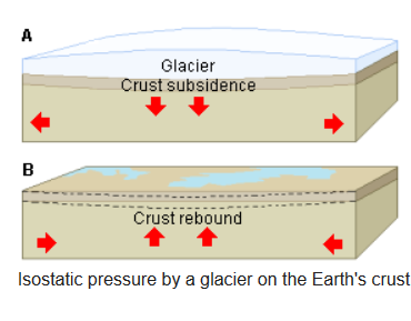
Glacial rebound can happen smoothly or gradually, or may happen in quick jumps. The upper Lynn Canal has risen over 300 feet since the last major glaciations. Glacial rebound may have stopped for a bit during the little ice age glaciation but it has since resumed. Since the little ice age, the story of Skagway continues as the Lynn Canal has risen 18.7 feet at a rate of .95 in/year. The Skagway Valley currently rises at a rate of .76 in/year compared with the Juneau Valley that rises .51 in/year.
Thank you for visiting this earthcache. Please send your answers to the questions to the cache owner, once you have feel free to log it. In your "found it" log feel free to write about your experience, but don't include the earthcache answers. Thanks and we hope you enjoy beautiful Skagway!

Sources:
http://skagway.com/
https://www.nps.gov/klgo/learn/nature/glaciers.htm
http://www.newworldencyclopedia.org/entry/Glacier
Living with the coast of Alaska by Owen Mason
http://www.newworldencyclopedia.org/entry/Glacier