The local geology and terrain characteristics of Dupont State Forest make it a unique portion of the southern Blue Ridge province. Igneous bedrock, predominantly granite and gneiss, is the primary parent material throughout the forest, and the weathering of that parent material has resulted in upland soil that is generally sandy loam in composition and acidic. Granite rock outcrops are present throughout the most exposed portions of the property, particularly in the vicinities of Big Rock, Cedar Rock, Long Rock, and Stone Mountain. Stony loam soils are common in the steeper portions of upland areas of the forest. Fine sandy loam, silt loam, and loam soils are present throughout areas adjacent to streams and in floodplains.
As the water of the river flows across the exposed bedrock it has eroded a couple of geomorphologic features characteristic of fluvial (http://en.wikipedia.org/wiki/Fluvial) environments on bedrock -- flutes and potholes.
Flutes –- Flutes are wavy smooth channels ground into the bedrock by fast flowing water. These form by the erosion of the bedrock by the unending grinding of suspended, saltating (http://en.wikipedia.org/wiki/Saltation_(geology)), and rolling particles against the bedrock. The chemical breakdown of the bedrock by the weakly acidic water helps to continue this erosion even when there are no particles in the water flow. As the water flows over the same pathway across the bedrock and forms a smooth channel. Overtime, the surface of the bedrock becomes polished and smooth.
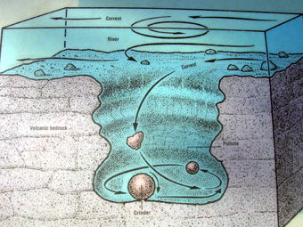
Potholes –- Potholes form where a rock (or many rocks) is spun around in the same spot by circular eddy of water. The constant abrasion begins to wear away the bedrock into a hole. Once started, the feature is self-reinforcing as the hole creates an even stronger eddy. The rock being spun in the hole is called a grinder and as one grinder wears away another rolls in to fill its place. Most of the work is done during periods of high flow/flood events when the velocity of the water is best able to move the grinders.
When two potholes form close together, they sometimes merged into one larger pothole. As the rocks and swirling water slowly increase their size the wall between them eventually wore away, forming a single pothole. Sometimes you may also see “half potholes” which occur after the pothole was carved, when countless freeze thaw cycles split apart a piece of the bedrock leaving only a semi-cylindrical cross-section.
Logging requirements:
Send me a note with :
- The number of people in your group (put in the log as well).
- Where are the flutes in relation to the current water flow?
- Where are the potholes in relation to the current water flow?
- Can you find a pothole with an active eddy that is being eroded?
- Where are the potholes in relation to the current water flow?
- Can you find a pothole with an active eddy that is being eroded?
- Can you find a merged pothole?
- Can you find a half pothole?
FTF HONORS GO TO wncsteph!!!