The point you're standing on, is one of the most prominent on the island. It offers a scenic view to the Grand Harbour from the Upper Barrakka gardens. The Grand Harbour is a stretch of sea which is surrounded by Valletta, Floriana, Marsa, the three cities (Birgu, Bormla and Isla) and Kalkara. The harbour was the scene or many battles which make up the history of the Maltese islands. In fact, the major fortifications lie on the grand harbour. The harbour is the beating heart of the Maltese islands, since many shipments, ferries and cruises go through it.
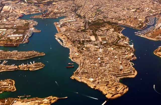
But have you ever wondered how this natural port formed? In the ancient times, when the Mediterranean sea was shallower the Grand Harbour was a series of individual valleys, some very small, and some quite big (considering the size of the Maltese islands) which all drain into the same valley. The most prominent valley spanned from Qormi/Marsa to Valletta in the north east direction. This valley formed naturally by water eroding off rock as it passed from Rabat, Siggiewi, Zebbug area to Valletta creating a deep channel that extends from Marsa to Valleta for about one kilometre. Similarly, smaller valleys in Marsa, between Birgu and Isla and in Kalkara formed creeks which form part of the Grand Harbour.
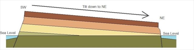
Normally, such formations would form shallow bays with beaches rather than a deep water harbour. A cataclysmic geological event took place in the middle of the Mediterranean which caused seismic upheaval as a result of tectonic movement. This is the same event that formed the great fault where Malta rose from the western flank causing a more tilted cross-section of the island. After the last ice-age started to end, the sea levels started to rise. This tilt to the east caused the flooding of the Grand Harbour valley system, which was to be submerged quite heavily, forming the wonder which is the Grand Harbour today. If it wasn't for this cataclysmic event, the area would have been a large valley system gently shelving into the sea somewhere where the Valletta breakwater currently stands.
Now to the cache: To log a found, please send me an e-mail and answer the following Questions:
- What is the height of your standing point above sea level (in metres)?
- Malta is made up of a stack of rock sediments, can you name the one at the edge of the land around the harbour? Explain the looks of it and why you think it's your pick?
- Look right across the grand harbour, you will see 2 forts. One of them has a small watch tower. Can you mention the name of that fort and the name of the location (city - Maltese name please)?
- Please mention another harbour (in Malta) with a similar geological + historical story? Where is it located?
- The piece of land on which Valletta lies, has a name due to the characteristics which surround it. What is this piece of land called, technically? (have a look at hint if you don't know :) )
It would be nice, if you could take a photo of you or your gps with The Grand Harbour in the background.
Answers are not that difficult, should you feel a little help is required, ask the locals. Go ahead and ask the local people, many are very keen to help out. :)
You can log this freely, after sending your e-mail. I will contact you, in case of problems with the answers. Hope you learn more about this area (and Malta in general) and hopefully enjoy the nice views.