[JP]
根無地塊は、水平に近い低角度の断層によって,基盤となる地層上を水平に近い角度で移動してつくられた岩体 (ナップ ) が,浸食によって削られ,一部分のみ島のように取残された地塊のことです。下の地層とは断層で切られ,根がないということからこの名がある。クリッペとも呼ばれ、地学用語としてはクリッペのほうが一般的です。
[EN]
Klippe is land blocks formed as follows:
1. Rock body, called as "nappe", runs on a bedrock at a shallow angle closer to horizontal;
2. The nappe is eroded as the bedrock upthrusts;
3. Parts of the nappe are left as klippe like islands.
Klippe is fault-bounded from the underlying bedrock.
[JP]
下仁田ジオパークのWeb siteに公開されている以下のリンクのビデオがクリッペを非常に分かりやすく解説していますので、ご覧ください。
[EN]
Please watch the video clip (provided by Shimonita geopark website) with the link below, which video well explains how Klippe is formed.
[JP]
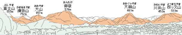
下仁田の中心街から南の山々見た下図においてオレンジ色で示された山がクリッペです。クリッペは、主に白亜紀(約8000万年前)の海の地層とペルム紀(約2億7千万年前)のマグマが地下で冷え固まった石英閃緑岩という岩石で構成されていますが、下仁田のナップとクリッペがいつ、どこからどのように動いてきたかについては、いまだに明らかになっていません。
[EN]
The figure below shows, by orange color, the mountains seen from the central area of Shimonita town, which mountains are klippe. The klippe consists of marine strata formed mainly in the Cretaceous (about 80 million years ago) and quartz diorite into which magma was cooled and solidified under the ground in the Permian (about 270 million years ago). However, it has not yet been revealed when, from where and how the nappe and klippe in Shimonita town came there.
[JP]
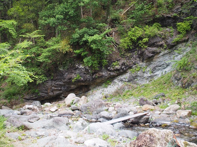
公開座標では、クリッペの元となるナップが基盤岩の上に乗り上げている様子を観察することができます(下写真)。
[EN]
At the published coords, you can observe that the nappe, which was eroded into the klippe, is running on the bedrock (see the picture below).
[JP]
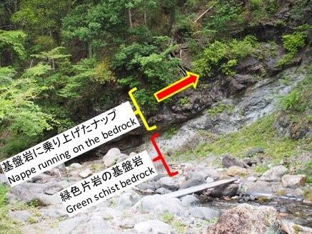
下の写真は、基盤岩及び乗り上げたナップを図解します。
[EN]
The picture below is provided with annotations
[JP]
上側のナップ層は、下側の基盤層上にオーバーハングしているため、ナップ層の下面を観察することができます。この下面には、上側のナップ層が下側の基盤層の上に乗り上げて擦れ合った際に付いた擦れ跡を観察することができます。下の写真において、矢印で示した方向に擦れ跡が付いています。
[EN]
The upper nappe layer is overhanging over the lower bedrock layer, thus you can observe the bottom surface of the upper nappe layer. On the bottom surface, you can observe "scratch" caused when the upper nappe layer runs on the lower bedrock layer and they grides against each other. In the picture below, the scratch is in the direction of the arrow (if you see it directly, it is more visible).

Found logのためのタスク/Task for claiming your Found log
[JP]
以下のQ1-Q2に対する回答をキャッシュ・オーナーに送ってください。
[EN]
Send the cache owner your answers for Q1-Q2 below.
Q1.
[JP]
公開座標を訪れて、上側のナップ層の下面を観察し、上側層と下側層が擦れ合った跡の方位(東西南北)を確認しましょう。上側層はどの方位に動いたのでしょうか?
[EN]
Visit the published coords, observe the bottom surface of the upper nappe layer and check the azimuth orientation (i.e. north, south, east, west) of the scratch caused the friction between the upper and lower layers. Into which orientation is the upper nappe layer moving?
Q2.
[JP]
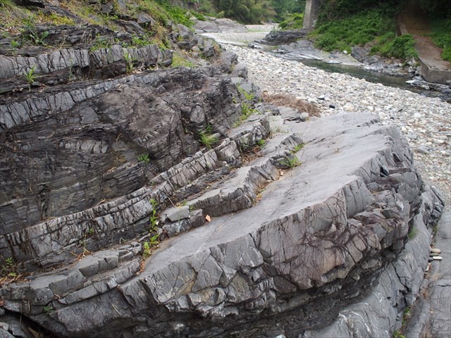
Additional Waypoint "Observation point 1"を訪れましょう。ここでは、クリッペを形成したナップの一部として、下の写真のような、タービダイトを観察することができます。
[EN]
Visit the Additional Waypoint "Observation point 1". Here you can observe. as part of the nappe and thus klippe, turbidite as shown in the picture below.
[JP]
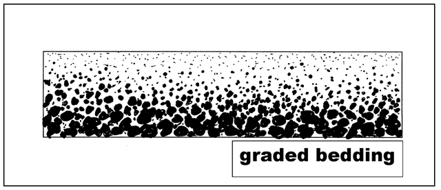
タービダイトとは、様々な粒度の石、砂や泥が混ざったタービディティ・カレント(混濁流)により運ばれた堆積物によって形成される堆積岩であり、タービダイト中には「級化層理」が発達していることが観察されます。
級化層理とは、粒径が大きな粒子ほど早く沈降することに起因して、単層の断面で,下から上に向かって堆積粒子の粒径が粗粒から細粒へと連続的に変化する構造を言います(下図. Washington State Colleges websiteから引用)。長年にわたり何度もタービディティ・カレントが発生することにより、下図の級化層理が複数繰り返された構造となります。粒径の変化の方向を観察することによって、その層が水中で堆積した際に、どちらが上向きだったかを判断することができます。
[EN]
Turbidite is a type of rock formed with sediments carried by turbidity currents with mixture of particles having a range of grain sizes, like stones, sands and mud. In turbidite, you can observe that "graded bedding" was developed.
Graded bedding is a structure in which, because the larger the particle size is, the faster the particle settles out, the grain sizes of the sediment particles gradually change from the base of the bed to the top (see the figure below. Cited from the website of Washington State Colleges). Repetition of turbidity currents results in a stack of such graded bedding structure. By observing the direction of change of the grain sizes, you can tell which is the upper direction of the bed when it settled out in the water.
[JP]
Additional Waypoint "Observation point 1"において観察されるタービダイト中の級化層理から、クリッペの元となったナップが基盤層に乗り上げるという地殻変動は、非常に大きな力が作用した結果であることが分かります。それは何故でしょうか? 級化層理の向きに注目してみましょう。
[EN]
By observing the graded bedding at the Additional Waypoint "Observation point 1", you can recognize that the land deformation causing the nappe layer to run on the bedrock layer resulted from a great force acted. Why is that? Pay attention to the direction of the graded bedding.