To claim this Earthcache, you must provide the answer to the question at the end of the cache description.
Higgins Lake is a large recreational and fishing lake in Roscommon County, in the U.S. state of Michigan. The 9831 acre (40 km²) lake is known for its deep, clear waters and is the 10th largest in Michigan with a shoreline of 21.3 miles (34 km). It is named after Sylvester Higgins, the first chief of the topographical department of the Michigan Geological Survey. It has a maximum width of 4 miles (6.4 km) and a length of 7 miles (11 km) with a maximum basin depth of ~135 feet (41 m). The mean depth is 41.3 feet (13 m) and the lake contains almost 20 billion cubic feet (570 million m³) or 459,156 acre feet of water. Its retention time is about 12.5 years. The lake's watershed covers 19,000 acres (77 km²) or 29.5 square miles. The twin-lobed lake receives 51.3 percent of its water from submerged springs, 5.7 percent from incoming streams, and the remaining 43 percent from direct rainfall and runoff.
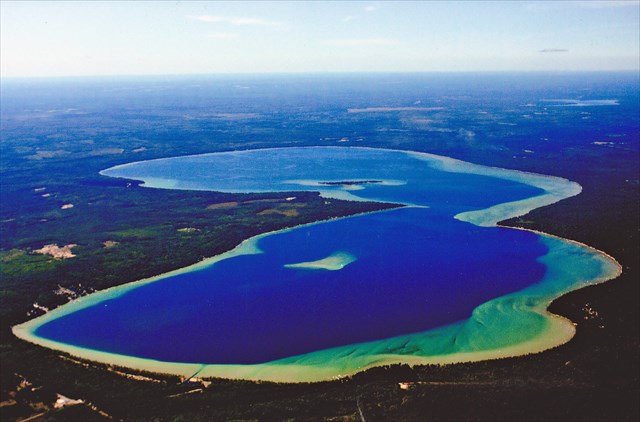
Arial photo of Higgins Lake sparking like a sapphire.
Though the 'official' depth of the lake is 135 feet, the numerous large springs that provide groundwater, it is unknown just how far they extend. One Indian legend tells the tale of a chief that was hauling a load of furs across Lake Michigan's Traverse Bay when a storm capsized his canoes- his body was never found, but identifiable parts of his lost canoe were found floating in Higgins Lake weeks later.
Other stories involve lumberjacks during the logging era from 1875 ~ 1900 in which they used to move a logging barge across the lake using a unique method of propulsion. The barge was fitted with a large winch capstan powered by a team of horses. A large stone block anchor was attached to the end of a long rope (some say was ~1500' long)... the anchor would then be put into a rowboat and rowed out a distance from the barge in the direction they wanted to go, the anchor dropped into the water & the horses would then walk around in a circle on the capstan winch and pull the barge forward. Occasionally, the anchor would end up falling into a spring pocket & never touch the bottom... and then would have to be re-wound back up before they could move the barge again!

The Lumberjack barge driving logs on the lake.
Higgins Lake is also the true headwaters for the Muskegeon river- it drains into Marl Lake from the Cut River which runs into Houghton Lake and then down the Muskegeon and eventually to Lake Michigan. A mile north of the lake, water flows into the Lake Huron watershed via Beaver Creek, which is a tributary of the AuSable river. Higgins lake was created during the last ice age that covered North America over 12,000 years ago. During this rather recent event (geologically speaking), vast sheets of ice in the form of glaciers gathered in the snowfields of Canada and slowly deployed over the surface of the northern half of the North American continent burying its surface to an average depth of over 6,000 feet. There were four major centers of refrigeration and ice accumulation, and several of minor importance in North America during this epoch. One of these centers, the Labradorean, occupied the plateau east of James Bay. From this area the greatest extent of movement was to the southwest where the ice advanced 1,600 miles beyond the center. In its climax of expansion, this ice sheet extended southward to the approximate position of the Ohio River whose course was more or less definitely established along its border. This glacier also advanced slightly into southern Illinois, and Kentucky. It was this ice mass that deployed over Michigan in several invasions and was responsible for the development of its present configuration. The glacier of the last ice age effectively carved out the bedrock that created the basin of Higgins Lake, and while doing so, uncovered several pocket areas of free-flowing groundwater that may be a large underground river extending across the state. Numerous stories & legends going back in time of local Indian tribes describe this phenomena including the Grand Traverse Indian lost fur trader legend referenced above. An interesting phenomena in regards to the various spring pockets throughout the basin, is that they are known to migrate and move occasionally along the basin of the lake. During the winter when the lake is frozen over, occasionally dangerously thin ice-domes can appear on the surface of the ice that indicate a location of an underwater spring pocket.
Another geological impact of the glacial retreat as it melted also created many hilly moraines as the vast amounts of sand, gravel, and boulders were carried along and left behind as debris. There is a large & productive gravel pit that has been in operation for nearly a century that is just south of nearby Marl Lake. There are many erratic boulders throughout the area as you walk the neighboring woods, just as there are also several sand dunes in the area as well. All are remnants of the same glacial retreat that created Higgins Lake!
Sportfish in the lake include yellow perch, trout, smelt, small-mouth bass and pike. Fish are taken both in open water and by ice fishing. Higgins Lake is considered a morphometrically oligotrophic lake, meaning that its large size causes it to appear and function as a nutrient-poor lake although it receives a fair amount of nutrients.

Interpretive sign marker.
"Early surverors of Michigan found Native American encampments on the shores of Higgins Lake. The Chippewa called it "Xxxxxxxxxxx" or "sparking water". Years later, the National Geographic Magazine would rank Higgins Lake as the 6th most beautiful lake in the world.
For native peoples, the lake was an important link in crossing the state by canoe. This was accomplished by moving up the AuSable River from Lake Huron, entering Beaver Creek less than two miles from Higgins, making a short portage to Higgins Lake, traveling the Cut River to Houghton Lake and paddling down the Muskegon River to Lake Michigan.
In 1839, John Brink of the State Geological Survey mapped and named Michigan's tenth largest lake Forgison Lake. Following a 1852 survey by William A. Burt, the lake was renamed Higgins Lake, in honor of Sylvester Higgins, a valued associate of our first state geologist and Houghton Lake namesake, Douglas Houghton. Sylvester Higgins drew most of the original maps of Michigan, complete with accompanying illustrations."
There is no actual cache at this location!
An important part of this lake's geology include several large springs spread across it's basin that make up more than half of it's water source. There are many theories of where this springwater comes from including some that believe it comes as far away as Lake Superior.
1)Where do you suppose that the volume of groundwater for the springs of this lake originates from?
2)What was the original first-known name of this lake from the Native Americans that lived here?
To claim this cache as 'found', you must send a message to the CO with your answers.>
Do not post spoiler pictures!