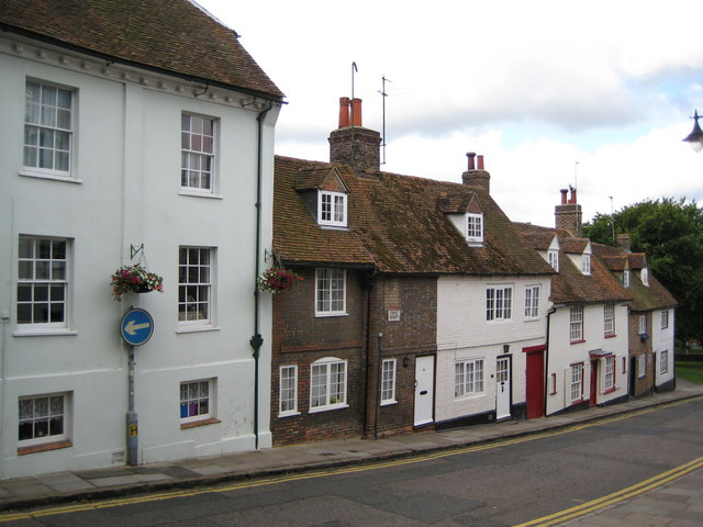
Houses on Castle Street
Wait a minute, a castle in Aylesbury? Are you serious?
That is a question that you may well find yourself asking at this point. The thing is that the –bury part of the name Aylesbury comes from the Anglo-Saxon word burh, meaning fortress. And one of the roads leading up the hill to old Aylesbury is called Castle Street, which points to there having been a castle somewhere around here, once upon a time.
But Aylesbury is slap bang in the middle of about 350 square miles of open flat land, known as the Aylesbury Vale. What on earth made our distant ancestors decide that this was the perfect place to build a castle? Read on to find out more!
Millions of years ago, where you are sitting now, all this was under a warm, subtropical ocean. This was during the Cretaceous Period, named after the Latin word creta, meaning ‘chalk’ because it’s the time in which the chalk making up the hilly outcrops of much of northern Europe were first deposited. The Upper (later) Cretaceous Period was when the nearby Chiltern Hills that can be seen on the horizon from much of Aylesbury were formed.
Where you are sitting now is much, much older than the Chiltern Hills.
Much of the landscape of the Aylesbury Vale between the Chilterns and where you are sitting is the exposed section of a layer of the local geology called Gault. Gault is a stiff blue clay that was deposited during the Lower (earlier) Cretaceous Period when the ocean covering this area was deep and calm.
But where you are sitting is still older, even than that.
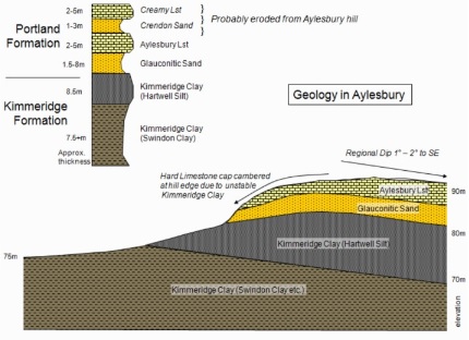
Aylesbury sits on a naturally occurring hill formed by an exposed layer of Portland Limestone and Kimmeridge Clay, formed during the Upper (later) Jurassic Period, roughly 142-151 million years ago. So that’s the same amount of time as from the formation of the Chiltern Hills to the modern day, doubled and then a bit added on for extra measure.

Image courtesy of Bucks Earth Heritage Group
So how did this layer of geology become exposed? The answer to that question lies in what happened when the sea level started to recede, about 40 million years ago. As the sea level dropped a river course was formed called the Proto-Thames, which was once a tributary of the Rhine, back when Great Britain was still linked to mainland Europe. The course of the Proto-Thames ran straight through this part of the Aylesbury Vale, and eroded many of the upper layers of chalk and clay deposits, exposing the Jurassic landscape that sat underneath.
Then during the last Ice Age, about 110,000 years ago, the course of the Proto-Thames was diverted through the soft chalk of the Chiltern Hills at Goring in Berkshire, creating the Goring Gap (where there is another superb earth cache) and forming the current route of the River Thames as we know it today. What was left here was a naturally occurring hill, overlooking the Gault vale surrounding it. And it is on this naturally occurring hill formed in the Jurassic Period that our ancestors decided to build a castle that would one day become the town of Aylesbury.
Which makes where you're sitting a genuine Jurassic Park!
Onto this cache!
As this is an earth cache there is no physical container to find or log book to sign. Instead answer the questions below and send them via my profile link at the top of the page. Remember to check the box to include your email address for a response.
Any logs made without an accompanying email may be deleted without further notice.
- Do some research on the Internet, or study a map of the UK. Whereabouts on the modern UK coast did the Proto-Thames reach what is now the North Sea?
- From the top of Castle Street (waypoint 1), take a walk down to the bottom (waypoint 2). How high would you estimate the hill on which old Aylesbury sits to be?
- Take some time to explore the local area, or look at a map of the town. The rough location of the castle was either in Kingsbury Square, St Mary's Square, Temple Square or Market Square. Which one do you think it was and why?
- Find St Mary's Church (waypoint 3). The church is the oldest building in Aylesbury, and was constructed using local materials. Which of the local materials mentioned above (Chalk, Gault, Limestone or Clay) was the building constructed from? Find a 10cm by 10cm section of the church wall and describe what you see, including colour(s) and texture. Are any sides of the church more or less weathered than the others? Why is this?
- (Optional) Draw or sketch an artist's impression of something Jurassic let loose in modern day Aylesbury, and take a photo of it for your log. Because it'll make me laugh!
Answering these questions requires you to move about the town centre, which will mean crossing roads. Please be careful, particularly with children. Thank you to Aylesbury Vale District Council and to St Mary's Church for agreeing to the placement of this earth cache.