Slide Rock in Oak Creek Canyon EarthCache
Slide Rock in Oak Creek Canyon
Please note Use of geocaching.com services is subject to the terms and conditions
in our disclaimer.
My family recently visited this area and had a great time playing here and learning about the forces that shaped Oak Creek Canyon and gave us this natural playground. We hope you have fun and learn a little about this area while you are here. Just a little warning for those who depend mostly on a smart phone to cache…coverage is virtually non-existent for many miles, so you might want to print this cache page before going.
 Slide Rock State Park is located in Oak Creek Canyon 7 miles north of Sedona. It takes its name from a natural water slide formed by Oak Creek. Slide Rock State Park is located on Coconino National Forest land.
 Oak Creek Canyon is about 12 miles long, ranging in width from 0.8 to 2.5 miles. The depth of the canyon ranges from 800 to 2,000 feet. However, due to the faulting that played a major role in its formation, the west rim of the canyon is 700 feet higher than the east rim. The average elevation of the west rim is 7,200 feet while the east rim elevation is 6,500 feet.
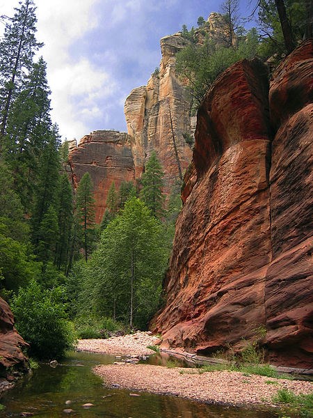 Geologic evidence suggests the formation of an ancestral Oak Creek Canyon along the Oak Creek Fault about eight to ten million years ago. The ancestral Oak Creek Canyon was then filled in by gravel deposits and a series of lava flows between six and eight million years ago during the Miocene Epoch. About this time, the Oak Creek Fault became active again and the modern Oak Creek Canyon began to develop along the fault zone as a result of the erosional action of Oak Creek. This small portion of the Oak Creek Canyon boasts a wide variety of wildlife and rock formations. About 2 million years ago Oak Creek Canyon developed suddenly due to the movement created by the Oak Creek Fault.
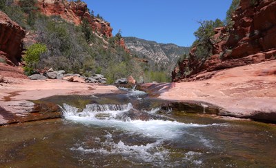 Please exercise caution, while this location is safe, the current can change depending on weather and season. The rocks, outcroppings, cliffs, and varying terrain can present hazards. This is a beautiful spot, but like many of nature's beauties it has its own dangers and must be respected. Do not disturb the environment, remove rocks or in any way damage the area.
 In order to log this earthcache you must email me the answer to these questions (please do not post answers in your log). We would also appreciate a photo with your log.
1. Find a shallow spot (or the actual “slide”) and describe how the rock feels compared to the dry rock you walked in on.
2. From the cords and information on the nearby sign (waypoint), look at the rocks on the canyon walls, tell me the formation name and age of the “Fine-grained red sandstone” and the “Buff to cream-colored with cross bedding patterns”. Which of these two formations is higher in elevation?
3. How many “major rock formations” make up Slide Rock? Can you count/identify them all?
4. Where else in Arizona are these same rock formations found?
5. The Oak Creek Fault created a weak zone for the erosional forces of what 3 things?
6. Extra credit (not required to log)… take a leap off the small cliff close to GZ, or any deeper area and describe what the bottom feels like.
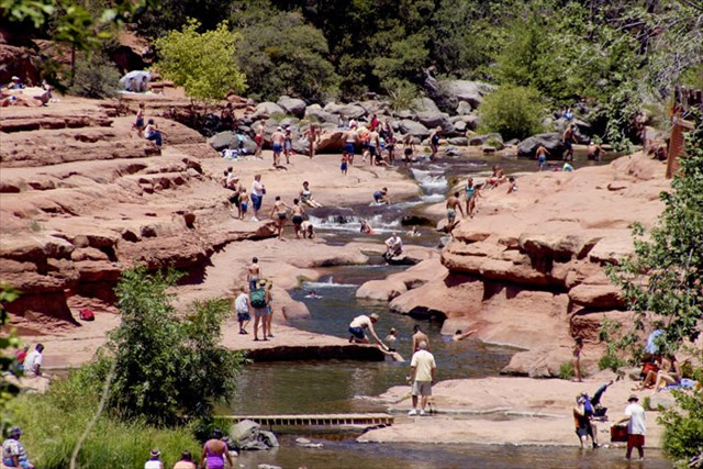 There is a fee to enter Slide Rock State Park. Monday-Thursday: $20.00 per vehicle. Friday-Sunday: $30.00 per vehicle. Holiday Weekend: $30.00 per vehicle
Click here to visit the state park web site for park hours fees and seasonal info.
There is a fee to enter Slide Rock State Park. Monday-Thursday: $20.00 per vehicle. Friday-Sunday: $30.00 per vehicle. Holiday Weekend: $30.00 per vehicle
Click here to visit the state park web site for park hours fees and seasonal info.
Additional Hints
(No hints available.)
Treasures
You'll collect a digital Treasure from one of these collections when you find and log this geocache:

Loading Treasures