The aim of this Earth Cache is to give you some insight into the development of the Point at Mossel Bay, why is looks the way it does.
The natural swimming gullies at the Point, the bluff and the long ridge are part of Mossel Bay's enchantment. To explain this phenomena it is necessary to go back reasonably far into the Earth's history. In fact, an entire four hundred and fifty million years.
At that stage the largest sand deposit on Earth was deposited in the Southern part of South Africa in a sedimentary basin that stretched from West of South Africa's West coast, to East of Kwazulu-Natal's East coast, and from just South of Beaufort West to far South of the Western Cape's South Coast. In the Western part of this sedimentary basin the sand attained a thickness of up to 5000 meters. About 300 million years ago, this sand layer, which by then had solidified into sandstone and which today is known as "Table Mountain Sandstone", together with thousands of meters of sediments that were deposited on top of the sandstone, was subjected to extremely slow but immense pressures from the South-South-West. As a result the rock layers were bent and folded just as the pages of a writing pad would fold if one would push them from the lower end.
During the folding of the rocks the sandstone was recrystallized to a greater or lesser extent to a hard and resistant quartzite. (The name "Table Mountain Sandstone" is therefor misleading, as this original sand deposit has long since not been been a sandstone but a quartzite.) The folding of the rocks was followed by large scale erosion during which immense amounts of the overlying softer rocks as well as parts of the quartzite were eroded away. The combination of these processes resulted in the formation of the well known fold mountains of the Cape, the cores of which are formed by the resistant quartzite.
In the vicinity of the large swimming gully at the Point, known as the "Poort", one can clearly see how the quartzite layers, which originally were laid down horizontally, now lie in an east-west direction and were tilted to the South at about 50 degrees during the folding of the rocks. The somewhat softer layers were eroded out more deeply than the harder layers and in this way the gullies, which are now being used as natural swimming and tidal pools, were formed.
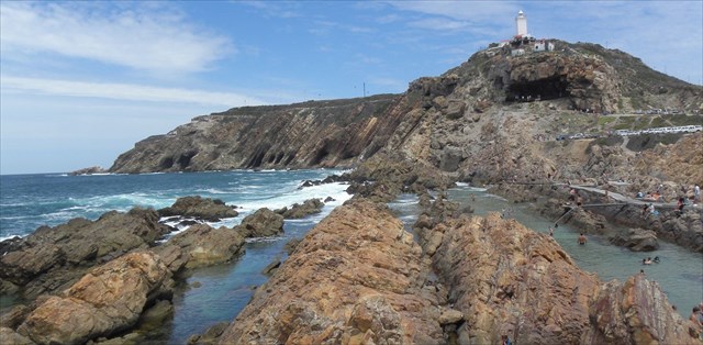
Should one look to the West from the Point of from the observation deck at the lighthouse, one can clearly see the same southwards tilted quartzite layers with a number of caves some six meters above the water line. These caves were eroded out by the waves while the sea was at this level. Some 120 million years ago, after the weathering and erosion of very large amounts of softer rocks, and to a somewhat lesser extent also the quartzite, the surface in the Mossel Bay area was distinctly uneven. The resistant quartzite formed the Mossel Bay bluff and ridge.
Just North of the Point, at the coordinates, the contact between the sandstone and the steeply dipping quartzite of the Table Mountain Sandstone is beautifully exposed. Here, the 120 million year old erosion surface on top of the quartzite can be seen. A thin layer of erosion debris, consisting of angular to half rounded fragments of quartzite, cemented by dark grey clay material, lies directly on the South dipping quartzite. A thin layer of dark grey shale, originally a clay layer, lies directly above this debris layer, followed by the younger Cretaceous sandstone.
A very interesting phenomenon is the brightly colored, stained quartzite immediately below the old erosion surface or contact at this location. Here it can be seen how iron oxide, which was leached out of the weathered and eroded quartzite, filtered into and along cracks in the rocks immediately below the erosion surface of the time and stained the quartzite a beautiful red, yellow and brown colour. These stains extend a short distance only below the ancient erosion surface in what, at the time, was the zone of oxidation.
In order for you to qualify to log this cache, you need to email me the answers for the following questions. You can either use the send message feature, or my email address in the hint below.
1) What is the average thickness of the layers where you stand at the coordinates?
2) How old is the erosion where you are standing right now?
3) In the description above, what is the angle in degrees in which the quartzite layers are tilted to the South?
4) Describe the coloring of the rock fragments you seen cemented in the lowest layer, just above the sand?
5) Please post any photos of the stained quartzite you see if possible. (This is only optional)
REFERENCES: Chris T Potgieter written for the Mossel Bay Heritage news letter Volume 7 Issue 4.
