IT
La valle Antigorio è una tipica valle glaciale „a gradinata“, in cui tratti pianeggianti si alternano a bruschi cambiamenti di pendenza, o very e propri salti, che determinate talvolta la formation di cascade (ne è un esempio spettacolare la Cascata del Toce in Val Formazza). L´incisione in cui ci troviamo si sviluppa entro uno di questi gradini rocciosi, che si interpone tra Uriezzo (635 m) e l´alveo del Toce a Maiesso (550 m), con un dislivello di circa 85 metri.
La rocca entro cui sono stati scavati gli orridi sono i micascistia granato, ricchi di lenticelle pieghettate di quarzo biancastro che, essendo più duro rispetto alla roccia circostante, si presenta spesso in rilevo (erosione selettiva). Il fondo roccioso non è visible, perchè ricoperto da depositi di materiale alluvionale e morenico.
Gli Orridi di Uriezzo sono profonde incisioni in roccia scavate da energiche cascate, in arretramento progessivo, facenti parte dell´antico sistema di torrenti che scorrevano sul fondo del ghiacciaio che percorreva la valle. Succssivamente, con il ritiro dei ghiacciai, l´andamento della locale rete idrgrafica si è snesibilmente modificato: la peculiarità degli Orridi di Uriezzo consiste proprio nel fatto che il torrente che li ha modellati ora non percorre più queste strette incisioni, pertanto è possilbile camminare agevolmente all´interno di esse.
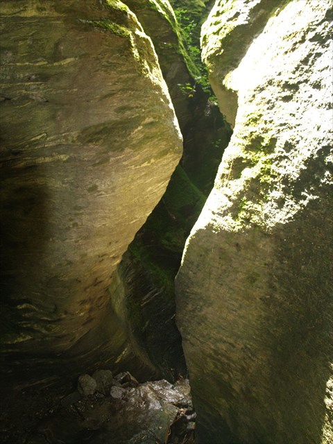
Immagine 1
Gli oridi accessibili e visitabili sono tre, denominati Orrido Su (il più spettacolare, lungo circa 250m e profondo da 20 a 30 m), Orrido Nord-Est (lungo circa 100 m e profondo circa 10 m, molto stretto in alcuni punti) e Orrido Ovest (format da due tratti distinti in succession, per una lunghezza di circa 150 m). Esistono altri orridi minori, ma difficilmente raggiungibili e pericolosi.
Gli orridi constituiscono un ecosistema complesso in cui costanti condizioni di elevata umidità e scarsa illuminazione, nonce la presenza di pareti lisce e levigate, determinano difficili condizioni ambientali a cui si adattano.

Immagine 2
Sulle domande:
1. Le piante che sono stati appositamente adattati alle condizioni del orridi?
2. Prima del terza scala di ascensione (da WP1 a WP2): Determinare il diametro della dilavamento circolaro passano attraverso. Spiegare con le tue parole come potrebbe essere creato questa cavità.
3. posizionare allo stesso: determinare la dimensione del quarzo bianco in prossimità del fondo (immagine 2). Spiegare con le tue parole perché il sporge quarzo
4. Determinare la larghezza del passaggio di immagine 1.
Una foto di voi nel canyon sarebbe bello.
Favore, invia le risposte tramite posta elettronica attraverso il nostro profile o per email to edle_stau
Generalmente rispondiamo molto velocemente. Attendi dunque la nostra autorizzazione al log!
DE
Das Antigoriotal ist ein typisches, gestuftes Gletschertal, in welchem sich ebene Bereiche mit sehr steilen Wänden abwechseln (ein schönes Beispiel hierfür ist der spektakuläre Toce-Wasserfall im Formazzatal). Der Abschnitt in welchem wir uns befinden, liegt innerhalb der felsigen Stufen zwischen Uriezzo (635 m) und dem Toce-Flußbett in Maiesso (550 m) mit einem Höhenunterschied von 85 m.
Die Felsen in die sich die verschiedenen Klammen gegraben haben, bestehen aus granathaltigen Glimmergneis mit vielen gefalteten rundlichen Einschlüssen von weißem Quarz, der, weil härter als das umgebende Gestein, häufig hervorstehend auftritt (selektive Erosion). Der felsige Boden ist leider nicht sichtbar, da er in einigen Bereichen von einer Lage aus Schwemmmaterial bedeckt ist.
Die Schluchten von Uriezzo sind tiefe ausgehöhlte Einkerbungen in den Felsen, die von energiereichen Wasserfällen in progressivem Rückgang hervorgerufen wurden. Sie sind Teil der alten Bach-Systeme, die unter dem Gletscher gen Tal flossen. Mit dem Rückzug der Gletscher hat sich der Lauf des lokalen Wassernetzes verändert. Der Fluss, der einstmals all dies modellierte, fließt nicht mehr durch diese Klammen, so dass man heute die Aushöhlungen bequem zu Fuß durchlaufen kann.
Bild 1
Drei der Klammen kann man besichtigen und begehen. Es handelt sich hierbei um die Süd-Klamm (die Spektakulärste, mit einer Länge von etwa 250 m und einer Tiefe von 20 – 30 m), die Nord-Ost-Klamm (ca. 100 m lang und ca. 20 m tief und an einigen Stellen sehr eng) und die West-Klamm (welche aus zwei verschiedenen aufeinander folgenden Bereichen besteht und ca. 150 m lang ist). Es gibt noch weitere kleinere Klammen, die jedoch sehr schwierig und nur unter Gefahr erreichbar sind.
Die Schluchten stellen ein komplexes ökologisches System dar, wo konstante Bedingungen, wie erhöhte Feuchtigkeit und wenig Licht, sowie glatte und abgeschliffene Felswände, schwierige Lebensbedingungen erzeugen, an die sich die Fauna anpassen musste
Bild 2
Die Fragen:
1. Welche Pflanzen haben sich besonders angepasst?
2. Vor der dritten Leiter (von WP1 zu WP2): Bestimme den Durchmesser der kreisrunden Auswaschung durch die Du gehst. Erkläre mit Deinen Worten, wie dieser Hohlraum entstanden sein könnte.
3. An derselben Stelle: Bestimme die Größe des weißen Quarz in Bodennähe (Bild 2). Erkläre mit deinen Worten warum der Quarz hervorsteht.
4. Bestimme die Breite des Durchgangs von Bild 1
Ein Foto von Euch in der Schlucht ware schön.
Bitte antwortet über mein Profil oder per E-Mail an edle_stau
In der Regel antworte ich relativ schnell. Bitte wartet die Loggenehmigung ab.
EN
The Antigorio valley is a typical, stepped valley formed by glacier, in which flat areas with very steep walls alternate (a nice example is the spectacular Toce waterfall in Formazza valley). The section in which we find ourselves, is within the rocky steps between Uriezzo (635 m) and the Toce river bed in Maiesso (550 m) with an altitude difference of 85 m.
The rocks in which the various gorges were engraved, composed of garnet-containing mica gneiss with many folded rounded inclusions of white quartz, which, because harder than the surrounding rock, often protruding occurs (selective erosion). The rocky bottom is not visible because it is covered in some areas by a layer of alluvial material.
The gorges of Uriezzo are deep hollowed indentations in the rocks that have been caused by high-energy falls in progressive decline. They are part of the old creek systems that flowed beneath the glacier down the valley. With the retreat of the glaciers watercourse has changed. The river that once all this modeled, no longer flows through these canyons, so that you can easily go through the excavations on foot today.
Picture 1
Three of the gorges can be visited. These are the South Gorge (the most spectacular, with a length of about 250 m and a depth of 20-30 m), the north-eastern gorge (about 100 m long and about 20 m deep and in some places very narrow) and the West Gorge (which consists of two successive fields and about 150 m long). There are other smaller gorges, which are very difficult and can only be accessed under threat, however.
The canyons are a complex ecological system where constant conditions such as increased humidity and low light, and smooth and beveled cliffs, difficult living conditions give rise to which the fauna has had to adapt.
Picture 2
The questions:
1. Which plants have been specially adapted to the conditions at the canyon?
2. Before you enter the third ladder (from WP1 to WP2): Determine the diameter of the circular hollow you go through. Explain with your own words how this hollow could be created.
3. At the same place: Determine the size of the white quartz at ground level (picture 2). Explain with your own words why the quartz protrudes.
4. Determine the width of the passage at picture 1
A picture of you at the canyon would be nice.
Please send your answer to my profil or via email to edle_stau
I replay normaly very fast. So please wait for our confirmation.
Maggiori informazioni/Mehr Informationen/More informations
Orridi di Uriezzo
Orridi di Uriezzo
Orridi di Uriezzo