Welcome to Hartshorne Woods in New Jersey's Atlantic Highlands.
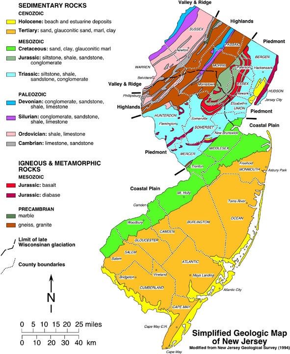
History of the region:Region: 65 million years ago the southern half of what is currently New Jersey was under water. Geologists estimate when large ice sheets waxed and waned, potential sea levels rose up to 300 feet above current elevations. During the Mesozoic Era also known as the Cretaceous period, the northern portion of NJ was above sea level. In the Coastal Plain Province of New Jersey, the Atlantic ocean advanced and retreated across the coastal plains numerous times. Late Cretaceous ocean tides and ancient rivers eroded the exposed Atlantic Highlands.
 As the Atlantic Ocean sea levels receded the southern half of NJ was exposed.
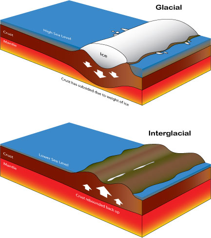
New Jersey experienced many glacial events and the tremendous weight of the ice would have crushed down on the earth's crust. As the ice melted the earth’s elevations rebounded. This is called Glacial Rebound and is one likely explanation for why the highlands are so high.
A thick and erosion resistant ironstone cap had formed over the Highlands. Over many years water eroded the iron and carried iron oxide (better known as rust) down into the sand where it was cemented into sandstone. The channels the iron-rich water took through the sediment became thin ribbons of iron oxide laced into the sandstone. It really is rust that gives these rocks and sandstone cliffs their red coloring.
The Sedimentary Highlands: Where did all of the sand come from in the first place? We can answer that by taking a close look at the sand. Mature sand is very fine grained and well rounded as it was ground down over long distances or in a high energy environment like a fast moving stream or tidal beach. Another characteristic of sediment is sorting. Well sorted sand is all approximately the same size. Lots of different grain sizes indicate poorly sorted sediment that is less mature. The sand found at the base of the hill is part of the aptly named Red Bank formation and probably originated in upstate New York and the northwest New Jersey and traveled quite a distance before settling here.

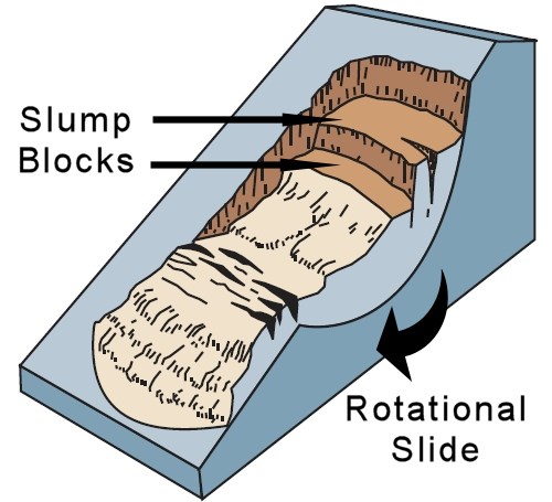
Slump Blocks and Slump Rocks: What goes up (glacial rebound) must come down (erosion/landslides). Multiple Rotational landslides or Slumps have occurred on the northern slopes of the Atlantic Highlands in the past several years. In the most recent case an unusual amount of rain saturated the slope which became too steep to hold its own weight and tons of earth, sand and rock poured down the hill into the Raritan Bay. The hills on Sandy Hook are possibly former highland slumps that have slowly moved further away from the mainland due to drifting. Here on the south side of the Highlands Ridge the sandstone is more strongly cemented but slumping has occurred over the years. Most notably, individual boulders have slumped off of the cliff on occasion and several large examples have come to rest on the beach. These boulders are now just another form of sediment!
To Log this Earthcache:
1) Start at Blackfish Cove (Posted Coordinates) and check out the sand down by the water. Is all the sediment the same type of material and size? The man-made road and constructions contribute to this.
2) Walk East along the beach - follow the trail through the reeds. When you come out of the reeds you will be on the red-rock beach. Now how does the sand look? Mature or Immature sediment?
3) Continue to the Conglomerate Slump Rocks waypoint (about 490 feet from the posted coordinates). How many major slump rocks do you see this location? Many others have likely been buried by the tides.
4) Continue to the Iron Oxide Laticework waypoint (about 630 feet from posted) and inspect the cliff wall as you walk. Estimate the average thickness of the bands of iron oxide running through the sandstone. You may find examples broken off at your feet. In some spots erosion has removed sand while leaving the cemented iron. Note the "stalactites" formed in these holes but look carefully as mice and cliff swallows live in some of these holes!
5) (Optional but recommended if not high-tide) Continue to the Largest Slump Rock waypoint about 720 feet from posted. How many legs does this rock stand on?
Applied Knowledge (Optional Extra Credit)
A) Gravity should have created primarily vertical bands of iron oxide run-off. Why are they now often horizontal? (Hint: How did they get rotated?)
B) Do you see any evidence that Blackfish Cove or Lower Rocky Point to the east were created by rotational slides and slumping?
C) Take only pictures, leave only footprints, be safe, have fun!
References:
Sedimentary Rocks
Sea Level and Coastal Changes
Slump Blocks
Atlantic Highlands
Geologic Map Database

This Earthcache has been placed with permission of the Monmouth County Park System.