Geology
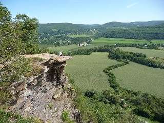
Vroman's Nose is composed of numerous layers of sedimentary bedrock. The uppermost and youngest layer is Hamilton Sandstone from the Devonian Era. Underlying this are older layers of softer shale and harder, more durable limestone. This unusual geological feature is undoubtedly the result of glacial action about 50,000 years ago, when a lobe of the great continental glacier moved across this part of New York and carved the slopes which form the present Schoharie Valley. This massive ice sheet gouged out the broad and deep valley, which was later filled with sediments deposited by a river of post-glacial meltwaters. This combination of glacial scouring and riverine erosion left an island of rock cutoff from the main body of bedrock that today is the plateau named Table Mountain and Vroman's Nose is that isolated island of bedrock.
What is a Glacier?
Glaciers are made up of fallen snow that, over many years, compresses into large, thickened ice masses. Glaciers form when snow remains in one location long enough to transform into ice. What makes glaciers unique is their ability to move. Due to sheer mass, glaciers flow like very slow rivers. Some glaciers are as small as football fields, while others grow to be dozens or even hundreds of kilometers long.
How are Glaciers formed?
Glaciers begin to form when snow remains in the same area year-round, where enough snow accumulates to transform into ice. Each year, new layers of snow bury and compress the previous layers. This compression forces the snow to re-crystallize, forming grains similar in size and shape to grains of sugar. Gradually the grains grow larger and the air pockets between the grains get smaller, causing the snow to slowly compact and increase in density. After about two winters, the snow turns into firn—an intermediate state between snow and glacier ice. At this point, it is about two-thirds as dense as water. Over time, larger ice crystals become so compressed that any air pockets between them are very tiny. In very old glacier ice, crystals can reach several inches in length. For most glaciers, this process takes more than a hundred years.
Why do Glaciers Move?
The sheer weight of a thick layer of ice, or the force of gravity on the ice mass, causes glaciers to flow very slowly. Ice is a soft material, in comparison to rock, and is much more easily deformed by this relentless pressure of its own weight. Ice may flow down mountain valleys, fan out across plains, or in some locations, spread out onto the sea. Movement along the underside of a glacier is slower than movement at the top due to the friction created as it slides along the ground's surface, and in some cases where the base of the glacier is very cold, the movement at the bottom can be a tiny fraction of the speed of flow at the surface. Glaciers periodically retreat or advance, depending on the amount of snow accumulation or evaporation or melt that occurs. This retreat and advance refers only to the position of the terminus, or snout, of the glacier. Even as it retreats, the glacier still deforms and moves downslope, like a conveyor belt. For most glaciers, retreating and advancing are very slow occurrences, requiring years or decades to have a significant effect. However, when glaciers retreat rapidly, movement may be visible over a few months or years
Types of Glaciers
Glaciers are categorized by their morphology, thermal characteristics, and behavior.
Alpine Glaciers, also known as mountain glaciers or cirque glaciers, form on the crests and slopes of mountains. An alpine glacier that fills a valley is sometimes called a valley glacier. A large body of glacial ice astride a mountain, mountain range, or volcano is termed an ice cap or ice field. Ice caps have an area less than 50,000 square kilometres (19,000 sq mi) by definition.
Glacial bodies larger than 50,000 square kilometres (19,000 sq mi) are called ice sheets or Continental Glaciers. Several kilometers deep, they obscure the underlying topography. Only nunataks protrude from their surfaces. The only extant ice sheets are the two that cover most of Antarctica and Greenland. They contain vast quantities of fresh water, enough that if both melted, global sea levels would rise by over 70 meters. Portions of an ice sheet or cap that extend into water are called ice shelves; they tend to be thin with limited slopes and reduced velocities.
Glacial Movement at Vroman's Nose
Large pieces of bedrock were moved across hills by the Wisconsin glacier, creating formations of cliffs on the south side of Vroman's Nose. The scouring sediment of the glacier caused the gentle sculpture of the north facing slope.
Glacial Lake Effect
During the time of climate fluctuation and glacial melting, Vroman's Nose was almost completely under water. The summit of the nose stood approximately 1220 feet while Lake Schoharie lay about 1170 feet. One striking feature of Vroman's Nose summit is that its flat surface rock of Hamilton Sandstone is covered with glacial graffiti—scratches (called striae) and chatter marks produced by stones protruding from the bottom of the moving glacier. These scratches show that the glacier was moving westerly. Very likely much, if not all, of the rock surface on the summit is covered with such glacial marks, but a thin layer of soil a foot or so thick covers most of this cap rock.
Glacial Striations
Glaciers are made of ice and rocks that get trapped in the ice. Glaciers flow downhill because of gravity. The moving glacier acts a lot like a bulldozer, stripping away layers of rock and moving them off to the side. Rocks embedded in the bottom of the glacier scrape along the newly exposed bedrock and leave behind line-shaped scratch marks. (We call these "glacial striations"). The direction of the scratch marks tells us the direction that the glacier flowed. These marks are evident at Vroman's Nose.

To log this earthcache, you must answer the following questions: Email your answer, Do Not Post it in your log. Logs without an email will be deleted.
1. As you arrive at Vroman's Nose, take a look at the formation. Can you tell what type of glacier formed Vroman's Nose? Explain how you came to this conclusion.
2. As you stand on the summit, take note of the striation marks on the flat rock surface. Based on your observation and what you have read about striation marks, can you tell which way the glacier was moving? Explain how you know this.
3. Please post a picture of yourself (gps) at the summit.
Visiting Info:
Vroman's Nose Trail is a 2 mile loop trail that offers scenic views and is rated moderate. The trail is primarily used for hiking.
Resources:
Signs at Location.
Wikipedia: https://en.wikipedia.org/wiki/Vroman's_Nose
All Trails: alltrails.com/us/new-york/Vromans-nose-trail
Wikimedia: http://wikimedia/org
Glacier landforms: https://nsidc.org/cryosphere/glaciers/gallery/grooves.html
https://en.wikipedia.org/wiki/Glacier
http://www.ancientforests.us/surveys/VromansNose.htm