Pokey Plodders Getting Boulder Event Cache
Pokey Plodders Getting Boulder
Hidden
:
Saturday, September 12, 2015
-
Difficulty:
-

-
Terrain:
-
Size:  (other)
Please note Use of geocaching.com services is subject to the terms and conditions
in our disclaimer.
| Pokey Plodders Getting Boulder |
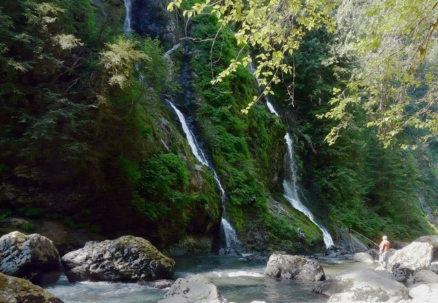
A relatively easy hike with waterfalls to admire and a river to keep us company.
It's eight miles long (round trip), but many small children do it every year. If your kid gets tired, it's possible to turn around at any point.
For this reason, the event will be the meet and greet in the parking lot (thus the 1/1 rating). The rating for the hike is probably a 2/3. (Hope that makes sense!) |
|
IMPORTANT INFORMATION
WHO CAN COME? All adult cachers and their families are invited, but cachers under 18 MUST be accompanied by a parent or guardian. Newer cachers and newer hikers are especially encouraged to join us.
WHEN? Saturday, September 12, 2015
WHAT TIME? 9:00-9:30 a.m. at the posted coords (Boulder River Trail parking lot)
The parking lot fills up quickly on a nice day, so we have to get there pretty early.
HOW LONG? Hike will probably take five hours or more at Pokey Plodder pace--just a guess.
WHAT SHOULD WE BRING? Bring food, water, etc. We'll be out there for a while. There are no facilities of any kind beyond the parking lot. The last toilet (outhouse) is along the road one mile from Highway 530, three miles before the trailhead. I think there's a cache there, though I've never stopped for it.
WHAT SHOULD WE WEAR? Dress for any weather. The last time I was here there were a couple of broken foot bridges over shallowish dips (easy scramble) and some mud.
DO I NEED A PASS? You will need a Northwest Forest Pass (one per car). Click here to see where to buy one.
CAN WE BRING OUR DOG? Leashed dogs are okay.
DIRECTIONS TO THE PARKING LOT:
Take I-5 to Exit 208 (SR 530 exit) and drive east for about 19 miles to milepost 41. Immediately after the milepost, turn right onto FR #2010 – some maps call this French Creek Road, but it’s not well signed. Follow the unpaved road almost four miles to its end and the trailhead. The road is rough and unpaved, but passable for a passenger car. This will take you longer than you think. Leave plenty of time. |
Additional Hints
(Decrypt)
V unir n fvyire Znmqn 3. V'yy gel gb trg gurer rneyl.