DEEP BLUE - DOLLABARAT

EARTHCACHE 

PORTUGUÊS

RECIFE DOLLABARAT

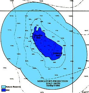
O recife de Dollabarat é um baixio que de localiza a 3 milhas náuticas a su-sueste dos ilhéus das Formigas no arquipélago dos Açores, nas coordenadas geográficas 37.23.3º N; 24.73.3º W.
A origem do seu nome está associada ao comandante basco Pierre Dollabarat, que a 7 de Março de 1788, a bordo do María de Sebourre, assinalou pela primeira vez a existência do recife.
Dollabarat é um recife de extensão considerável, tendo uma profundidade de mais de 1000 metros a Este e entre os 100 a 200 metros a Oeste (Canal das Formigas). Uma vez que o recife tem uma profundidade média de 15 metros, é constituído por rochas basáticas (grandes calhaus) e "é comum sentir-se sensação de que se está a mergulhar dentro de um aquário".

A profundidade mínima é de 3 metros abaixo do nível do mar. Trata-se de uma das zonas mais elevadas dos ilhéus das Formigas, constituindo-se num monte submarino de génese vulcânica (semelhante à das ilhas vizinhas), formado numa época em que aquela zona estava emersa. Por essa razão, os fundos são constituídos por acumulações de escoadas lávicas subaéreas de morfologia irregular, onde grandes maciços rochosos e zonas irregulares.
Dada a pequena profundidade e a elevada distância a terra, o Dollabarat é um local perigoso para a navegação marítima, cuja presença abaixo da superfície, em situação de fraca ondulação, só é perigosamente detetável a curta distância.
A transparência das águas é normalmente excecional, o que torna este local num dos "ex libris" do mergulho nos Açores. A possibilidade de correntes muito fortes, conjugada com as grandes diferenças de profundidade e a presença de tubarões, exige meios e experiência de mergulho em mar aberto.
Como zona oceânica, apresenta numerosa e diversificada fauna pelágica característica,como patruças, peixesporco, jamantas, lírios, tubarões, tartarugas e golfinhos. Os merossão frequentes entre os 10 e os 40 metros de profundidade.
O Departamento de Oceanografia e Pescas da Universidade dos Açores conduz missões científicas anuais para estudar e monitorizar este recife.
O Dollabarat encontra-se compreendido na Reserva Natural do Ilhéu das Formigas, com uma área de 52 527 ha, criada em 1988 e reclassificada em 2003 pelo parlamento açoriano como Reserva Natural Regional (Decreto Legislativo Regional n.º 26/2003/A, de 27 de Maio). Para além desse estatuto, pela Resolução n.º 30/98, de 5 de Fevereiro, do Governo Regional dos Açores, aquela zona foi incluída na lista de Sítios de Interesse Comunitário da União Europeia (Rede Natura 2000) com o código PTSMA0023. A decisão foi ratificada pela Decisão da Comissão de 28 de Dezembro de 2001 (2002/11/CE) pela qual foram aprovados os sítios de importância comunitária da Região Macaronésia em aplicação da Diretiva 92/43/CEE do Conselho (Diretiva Habitats).
Na área da Reserva Natural são interditos:

- quaisquer atividades de pesca, apanha ou colheita de organismos marinhos (incluindo caça submarina) com ou sem auxílio de embarcação, à exceção da pesca comercial de atum com linha de mão ou salto e vara, exercida por embarcações que integrem o sistema MONICAP;
- a colheita de material geológico ou arqueológico ou a sua exploração sem autorização emitida pela entidade competente;
- a perturbação, por qualquer meio, das aves que se acolhem nos Ilhéus; e
- o abandono de qualquer tipo de resíduos.
Os ilhéus das Formigas, onde se integra o recife de Dollabarat, constituem uma área de grande relevância internacional para conservação marinha que, para além da classificação como Sítio de Interesse Comunitário ao abrigo da Diretiva Habitats, está ainda incluído na lista de Áreas Marinhas Protegidas da Convenção OSPAR (Convenção de OSlo-PARis para a Proteção do Ambiente Marinho do Atlântico Nordeste).

O MERGULHO

A experiência única de mergulhar no Banco Dollabarat começa logo na viagem de 33 milhas náuticas da ponta Sudeste de São Miguel ou, as 20 milhas que separam estes ilhéus, da ilha de Santa Maria. A sua localização remota, e os encontros com as variadíssimas espécies que abundam nos mares dos Açores, elevam este local de mergulho a um dos melhores dos Açores.
O mergulho avançado (nível 3 de experiência), tem de ser feito de escafandro e é em mar aberto, sujeito a fortes correntes.
A zona do mergulho localiza-se numa “baixa””, conhecida no meio piscatório e junto dos entusiastas do mergulho com escafandro, como “DOLABARAT”. Este “banco” está, relativamente, próximo da superfície.
É uma zona onde é preciso ter muito cuidado, pois é um local que não fica “abrigado” pelas ilhas (Santa maria e São Miguel), sendo as correntes bastante fortes.
O mergulho neste local deve ser somente efetuado com mar calmo, pouco vento e sem vaga.
Este é um local recomendado apenas a mergulhadores experientes uma vez que se encontra longe de um porto de abrigo e num local propenso a correntes fortes.

Recomendações:
Convém sempre mergulhar acompanhado.
Tenha sempre em atenção, em primeiro lugar, a sua segurança!

PARA REALIZAR E REGISTAR ESTA EARTHCACHE:
Para realizar earthcaches “submarinas”, é necessário ir ao local, “ver bem” e estudar os fenómenos geológicos envolvidos…, aliás, como para qualquer outra earthcache… Devido às características destas caches, o owner recomenda que o “mergulho” seja bem planeado, com apoio de uma empresa certificada, tendo em atenção as condições meteorológicas (que, nos Açores, variam, por vezes, com grande rapidez) e que se mergulhe sempre acompanhado, como aliás “mandam as regras”.
PERGUNTAS:
Para “encontrar/registar” esta cache deverá: provar que esteve no local e responder às seguintes questões, enviando um email/mensagem de Geocaching, com as respostas, em português ou em inglês, para o nosso perfil.
Só depois, de enviar as respostas, e conforme as “guidelines” para as Earthcaches, deverá efetuar o seu registo!
Serão removidos todos os registos que não obedeçam a estes requisitos.
1. Estudando o tema geológico proposto nesta earthcache, responde às seguintes questões geológicas:
a) Descreve do ponto de vista geológico, como é constituído o “fundo” deste recife.
b) Explica o que é uma escoada lávica subaérea.
c) Qual a profundidade mínima e média deste recife?
2. A partir das observações que efetuou durante o seu mergulho, responda às seguintes questões:
a) Qual é a profundidade no GZ?
NOTA: é aceitável um diferencial de 3 metros, devido à oscilação da maré.
b) Estima o “tamanho” deste banco.
c) No fundo do mar (ou seja na superfície do recife), na zona do GZ, que tipo de disjunção é observável?
d) Como é coberta a superfície do recife, na zona do GZ?
3. TAREFA OBRIGATÓRIA:Deverá tirar uma foto sua, onde você apareça (ou com um papel/placa onde conste o seu nickname e a data da visita) e que comprove a sua presença no GZ (portanto o Farol das Formigas também deve estar visível na foto), desta EC - NÃO METASPOILERS. Esta foto deverá ser colocada no seu registo ou enviada por email ou sistema de mensagens de Geocaching, para o owner!

AGRADECIMENTOS:
Agradecemos a especial colaboração do amigo mergulhador Emanuel Cabral (Nelinho) e do amigo fotografo Nuno Sá.
Não responderemos ao seu contato, a não ser que haja algum “problema” com as suas respostas ou registo.


DEEP BLUE - DOLLABARAT

ENGLISH

EARTHCACHE

DOLLABARAT RECIFE

The Dollabarat Reef is a shoal situated 5 km (3 nautical miles) south-southeast of the Formigas Islets, on the Formigas Bank in the Azores archipelago.
The origin of the name is from Pierre Dollabarats, the Basque captain of the ship Maria de Sebourre, who had the unlucky honour of discovering the reef as his small boat wrecked on it on 7 March 1788.
The Dollabarat Reef is part of the Formigas Islets Nature Reserve which covers 35.42 square kilometres (13.68 sq mi). Around the Formigas Reserve, including the Dollabarat, the sea cliffs fall rapidly between 50 –70 metres (160–230 ft), although gently to the north and south. The gradient around the Dollabarat is less accentuated.
The highest point is just 3 metres (9.8 ft) below sea level. Dollabarat Reef is one of the higher parts of the Formigas Bank, a seamount with similar volcanic origins as the islands of the Azores. The reef was formed from rocks emerging from volcanic activity in submarine volcanoes and deeper spaces composed of drained lava holes with an irregular morphology. The deeper parts of the Dollabarat are covered with large rocks and irregular plains.
Dollabarat is a considerable extension reef, having a depth of over 1000 meters to the east and between 100 to 200 meters to the west (Channel of the Ants). Once the reef has an average depth of 15 meters, consists of basáticas rocks (large stones) and "it is common to feel sense of what is diving in an aquarium."
Given the relatively shallow waters, the reef is a peril to navigation (similar to sandy shorelines).
The strong currents, deeper waters and the presence of sharks makes diving difficult for those not familiar with open-ocean diving. The sub-tidal zone, is a shelter for many fish species, and the abundance of black coral, located around the 15 metere depth in the eastern part of the reef has resulted in a small habitat.
There is a large abundance of sea animals in the vicinity; in addition to species of sharks, other species such as sea chub, trigger fish, mantas, turtles and dolphins have been observed in these waters, including the Atlantic goliath grouper (usually found in depths between 10 – 40 m). The floor of the seamount is generally covered by a dense layer of seaweed, dominated by the Cystoseira species, a seaweed found in deeper areas. The Department of Oceanography and Fisheries at the University of the Azores (Ponta Delgada) monitors and studies these species annually through scientific missions to the islets.
In the area of nature reserve are prohibited:
- Any fishing activities, taking or harvesting of marine organisms (including spearfishing) with or without the aid of the vessel, with the exception of commercial tuna fishing with hand line or pole and line, made by vessels that incorporate the MONICAP system;
- The collection of geological or archaeological material or their operation without a permit issued by the competent authority;
- The disturbance, by any means, the birds that receive us Ilheus; and
- The abandonment of any kind of waste.
The islets of Ants, which integrates the Dollabarat reef, are a major international importance area for marine conservation that in addition to the classification as a Site of Community Importance under the Habitats Directive, is still included in Marine Protected Areas List Convention OSPAR (Oslo Paris Convention for the Protection of the Marine Environment of the North).

DIVING

A unique experience of diving in the Bank Dollabarat starts right in nautical 33 miles drive from the Southeast tip of San Miguel or the 20 miles that separate these islanders, the island of Santa Maria. Its remote location, and encounters with many species that abound in the seas of the Azores, raise this dive site to one of the best of the Azores.
The advanced diving (level 3 of experience) must be made of diving and is open sea, subject to strong currents.
The diving area is located in a "low", "medium known in fishing and among diving enthusiasts with diving, such as "DOLLABARAT ". This "bank" is relatively close to the surface.
It is an area where we need to be very careful because it is a place which is not "sheltered" by the islands (Santa Maria and Sao Miguel), and the very strong currents.
Diving on this site should only be done with calm sea, little wind and no wave.
This is a place recommended only for experienced divers since it is far from a place of refuge and a place prone to strong currents.

Recommendations:
It should always dive together.
Always make sure, first of all, your safety!
TO PERFORM AND LOG THIS EarthCache:
To perform "underwater" EarthCaches, you must go to the site, "see well" and study the geological phenomena involved ... Moreover, as for any other EarthCache ... Due to the characteristics of these caches, the owners recommend the "dips" are well planned with the support of a certified company, taking into account the weather conditions (which, in the Azores, vary, sometimes very quickly) and that immerse always accompanied, as indeed "send the rules."
QUESTIONS:
To "find / register" this cache must: prove that visited the site and answer the following questions by sending an email / message Geocaching, with answers (in Portuguese or in English, only) to our profile.
Only later, sending the answers, and as the "guidelines" for EarthCaches should make your registration! They will be removed from all records that do not meet these requirements.
1. Studying the geological theme proposed this EarthCache, answer the following geological questions:
a) It describes the geological point of view, as it is constituted the "bottom"
of this reef.
b) Explain what is a subaerial lava drained.
c) What is the minimum depth and Average reef?
2. From the observations made during a dive, answer the following questions:
a) What is the depth in GZ?
NOTE: A differential is acceptable 3 meters due to oscillation of the tide.
b) estimated the "size" of this bank.
c) In the bottom of the sea (ie the reef surface), in the area of GZ, what kind of disjunction is observable?
d) How is covered the surface of the reef, in the GZ area?
3.
TASK (not optional): You must take a picture of yourself, where do you show up, (or with a paper / plaque with your geocaching nickname and the date of the visit) and that proves your presence in the GZ (therefore the Lighthouse of Formigas must also be visible in the photo), of this EC - no spoilers please. This photo must be placed in your log or sent by email or Geocaching messaging system, to the owner!
We do not respond to your touch, unless there is a "problem" with their answers or register.

AGRADECIMENTOS:
We appreciate the special collaboration of the diver friendEmanuel Cabral (Nelinho) and photographer friend Nuno Sá.