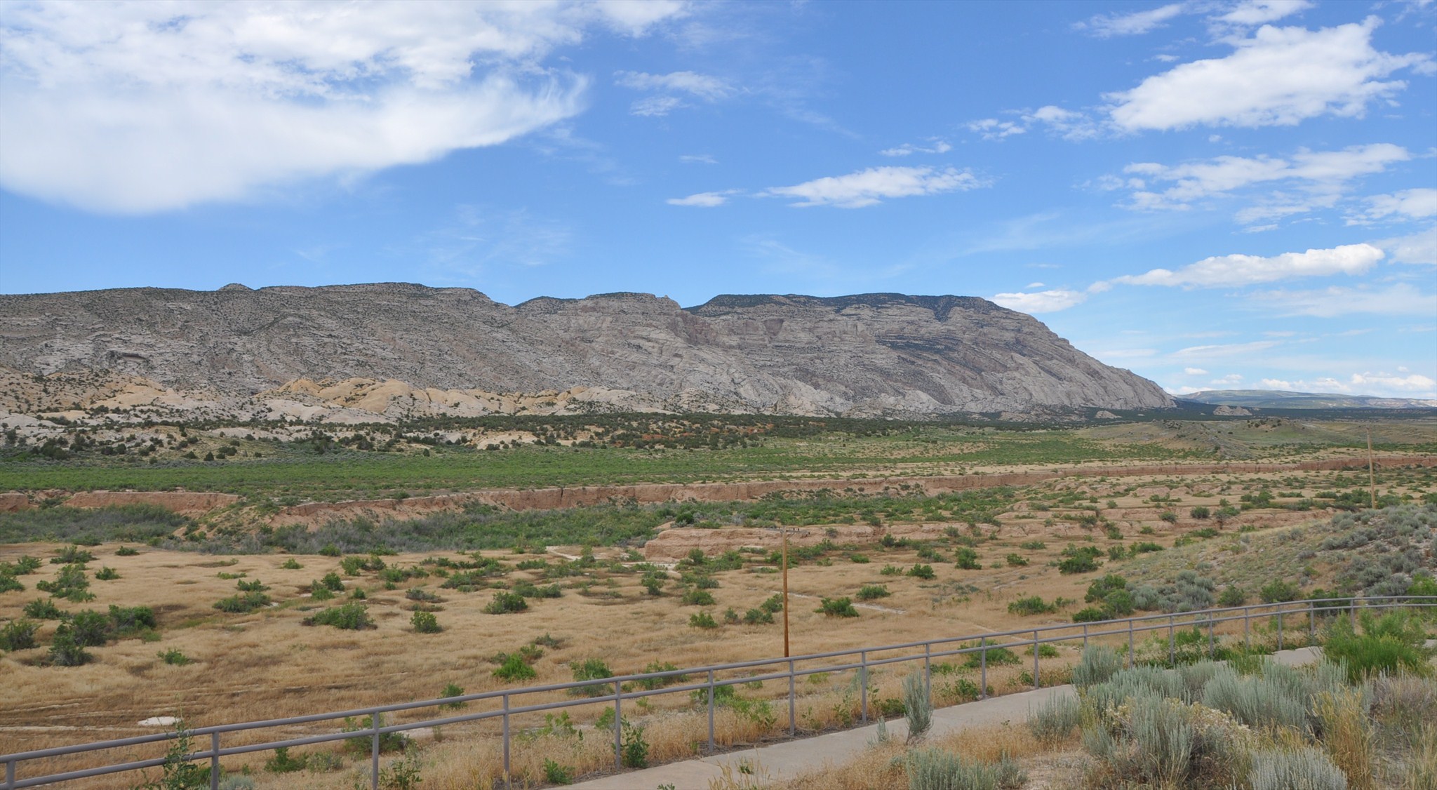
“Abrupt monoclonal folds characterize the flanks of the Blue Mountain block, which are grandly displayed. Monoclines are step like bends in otherwise flat or gently dipping strata. The monoclines were formed by the warping of strata across concealed faults, or by the sharp flexing of strata on the flanks of flat-topped anticlines. On Blue Mountain there structures owe their dramatic appearance to the erosive resistance of the Park City Formation, to the massive character of the underlying Weber Sandstone, and to the easy erosion of the overlying Moenkopi Formation. As the soft Moenkopi is stripped away, the Park City and Weber are left standing in enormous dip slopes and “flatirons.”
This is one of the more spectacular folds of this type, where Stuntz Ridge, a westward extension of Blue Mountain, forms a jutting promontory nearly 3,000 feet high. This remarkable flexure passes downward and laterally into a large fault. Other flexures nearly as dramatic form the north face of Blue Mountain, where the strata have been folded into sharp monoclonal bends along the Yampa fault and subordinate fractures in the stair step noted before.” (Hansen, W.)
The Uinta Mountains are an east-west trending chain of mountains in northeastern Utah extending slightly into southern Wyoming. As a subrange of the Rocky Mountains, they are unusual for being the highest range in the contiguous United States running east to west, and lie approximately 100 miles (160 km) east of Salt Lake City. The range has peaks ranging from 11,000–13,528 feet (3,353–4,123 m), with the highest point being Kings Peak, also the highest point in Utah.
The Uinta Mountains are Laramide uplifted metasedimentary rocks deposited in an intracratonic basin in southwest Laurentia during the time of the breakup of the supercontinent Rodinia. The marine and fluvial metasedimentary rocks in the core of the Uinta Mountains are of Neoproterozoic age (1000 - 541 million years ago) and consist primarily of quartzite, slate, and shale. These rocks comprise the Uinta Mountain Group. Most of the high peaks are outcrops of the Uinta Mountain Group. Many of the peaks are ringed with bands of cliffs, rising to form broad or flat tops. The mountains are bounded to the north and south by reverse faults that meet below the range, on the north by the North Flank fault and on the south by the Uinta Basin boundary fault.
The Uinta Mountain Group from oldest to youngest includes Uinta Mountain unidivided quartz arenite, overlain by the Moosehorn Lake, Mount Watson, Hades Peak, and Red Shale formations. The flanks of the east-west trending Uinta Mountains contain a sequence of Paleozoic and Mesozoic strata ranging from the Cambrian Lodore Formation to the Cretaceous Mancos Shale, all of which have been tilted during the uplift of the mountain range.
The uplift of the range dates to the Laramide orogeny, about 70 to 50 million years ago, when compressive forces produced high-angle reverse faults on both north and south sides of the present mountain range. The east-west orientation of the Uintas is anomalous compared to most of the ranges of the northern Rocky Mountains; it may relate to changing stress patterns and rotation of the Colorado Plateau.
The high Uintas were extensively glaciated during the last ice age, and most of the large stream valleys on both the north and south sides of the range held long valley glaciers. However, despite reaching to over 13,500 feet (4,110 m) in elevation, the climate today is sufficiently dry that no glaciers survived even before the rapid current glacial retreat began in the middle nineteenth century.
The Uintas are the most poleward mountain range in the world to reach over 4,000 metres (13,000 ft) without modern glaciers, and are in fact the highest mountain range in the contiguous United States with no modern glaciers. Permafrost occurs at elevations above 10,000 feet (3,000 m) and at times forms large rock glaciers.
Erosion
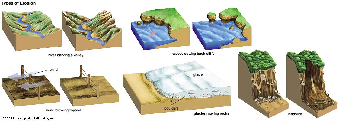
Erosion is the process by which soil and rock are removed from the Earth's surface by natural processes such as wind or water flow, and then transported and deposited in other locations.
Types of Erosion:
Splash Erosion: Small soil particles are detached and sent airborne through the impact of raindrops on soil.
Sheet Erosion: Raindrops break apart the soil structure and it's moved down-slope by water that flows overland as a sheet rather than definitive channels. This occurs frequently during cloud bursts.
Rill Erosion: This process develops small, short-lived, concentrated flow paths. These paths create a sediment source and delivery system for hill-slope erosion. Areas where precipitation rates exceed soil infiltration rates are more prone to this type of erosion.
Gully Erosion: Water flows in narrow channels during or directly following heavy rains or melting snow. The gullies can erode to considerable depths.
Valley or Stream Erosion: Continual water flow alongside land (along a linear feature) creates this type of erosion. It extends downward, deepening a valley, and head-ward, extending the valley into the hillside. This occurs most frequently in times of flooding.
Bank Erosion: Over time, banks of rivers and streams are naturally worn down.
Freezing and thawing: Cold weather causes water trapped in tiny rock cracks to freeze and expand, breaking the rock into several pieces.
Wind erosion is a major geomorphological force, especially in arid and semi-arid regions. Wind erosion is of two primary varieties: deflation, where the wind picks up and carries away loose particles; and abrasion, where surfaces are worn down as they are struck by airborne particles carried by wind.
Mass movement is the downward and outward movement of rock and sediments on a sloped surface, mainly due to the force of gravity. Mass movement is an important part of the erosional process, and is often the first stage in the breakdown and transport of weathered materials in mountainous areas. It moves material from higher elevations to lower elevations where other eroding agents such as streams and glaciers can then pick up the material and move it to even lower elevations. Mass-movement processes are always occurring continuously on all slopes; some mass-movement processes act very slowly; others occur very suddenly, often with disastrous results.
Source: (water)
**Logging requirements**
DO NOT POST ANSWERS IN YOUR LOG.
Send the following answers to me via email.
- The text "GC61Y4E Stuntz Ridge Scenic Overlook" on the first line
- What formation is still mostly not eroded?
- How many years ago did these formation become deposited?
- When looking at the mountain which general direction does the rocks bend towards?
Sources
- Victor R., Baker. Britannica, 2013. 0.
- Rader, A.. N.p.. Web. 4 Sep 2013..
- water: erosion. Art. Britannica Online for Kids. Web. 4 Sept. 2013.
- http://www.peakbagger.com/peak.aspx?pid=5507
- Hansen, W. (2005). The geologic story of the Uinta Mountains (2nd ed.). Guilford, CT: Falcon.
- https://gsa.confex.com/gsa/2001RM/finalprogram/abstract_6182.htm
- John McPhee, Basin and Range, New York: Farrar, Straus, and Giroux, 1981, pp.198-199
- http://rmg.geoscienceworld.org/content/43/1/1
- http://www.sciencedirect.com/science/article/pii/S0037073801000860
- http://geology.utah.gov/map-pub/survey-notes/glad-you-asked/does-utah-have-glaciers/
- http://www.geology.wisc.edu/~davem/abstracts/05-23.pdf
- http://www.wrcc.dri.edu/pcpn/ut.gif
- Probst, Jeffrey, and Probst, Brad, Hiking Utah's High Uintas, pg. 3, Morris Book Publishing, LLC, 2006
- Hamilton, W.B., 1981, Plate-tectonic mechanism of Laramide deformation, in Boyd, D.W., and Lillegraven, J.A., eds., Rocky Mountain foreland basement tectonics: University of Wyoming Contributions to Geology, v. 19, p. 87–92
| I have earned GSA's highest level: |
   |