It is an 11 miles drive from Dove creek to this scenic overlook. From Highway 491 take road J east till road 15; take road 15 north to the scenic overlook area. The roads are mostly gravel and dirt and that even my Toyota Corolla could get through fine on. The outer edges of the picnic area are surrounded by steep cliffs and potentially dangerous drops in some places without fences or obvious warnings, so use your best judgment with regards to children. The best time to visit here is between Spring and fall with midday to afternoon providing some of the best views. The road conditions to this scenic view and the view its self are subject to Mother Nature.
The Dolores River is well over 1,000 feet below and has been carving away at this canyon here for a long time. From here you can see where Dolores makes a sharp U turn and heads north which has created the Mountain Sheep point narrows. Dolores Canyon is cut through sedimentary layers of the Colorado Plateau, and river drops 25 feet one mile through this canyon and makes from some fun rafting trips. The McPhee Dam upstream has been regulating the flow of water through this canyon since 1985. (Gregory, L)
The Dolores River starts in a meadow called “Tin Can Basin” near 12,520 feet Hermosa Peak in the San Miguel Mountains. The river is only about 241 miles long and dumps into the Colorado River downstream and drains a rugged and arid region of the Colorado Plateau area.
The ancestral Dolores River is believed to have flowed south to join the San Juan River near the Four Corners in what is now northwestern New Mexico. The uplift of Sleeping Ute Mountain about 70 million years ago diverted the Dolores River to its present northward course, causing it to carve the Dolores River Canyon on its way to the Colorado River. The Dolores Canyon exposes rocks ranging from 300-million-year-old Pennsylvanian limestone to the 140-million-year-old Entrada sandstone deposited during the Jurassic. A cap of Cretaceous Dakota sandstone forms most of the upper rim of the canyon.
The lower Dolores River may have once been the original course of the Colorado River, which flowed through the now dry Unaweep Canyon, currently occupied by West Creek, a small tributary of the Dolores. When the Uncompahgre Plateau was formed it diverted the larger Colorado northwards through what is now the Grand Valley, looping around through Westwater Canyon to the confluence with the Dolores in eastern Utah and leaving Unaweep Canyon as a huge dry gap across the plateau. However, some geologists contend that the Colorado never flowed through Unaweep and the lower Dolores River, as the erosive force of the river should have created a water gap here; instead, the canyon may have been formed by glaciation during the Paleozoic.
The Colorado Plateau, also known as the Colorado Plateau Province, is a physiographic region of the Intermontane Plateaus, roughly centered on the Four Corners region of the southwestern United States. The province covers an area of 337,000 km2 within western Colorado, northwestern New Mexico, southern and eastern Utah, and northern Arizona. About 90% of the area is drained by the Colorado River and its main tributaries: the Green, San Juan, and Little Colorado.
The Colorado Plateau is largely made up of high desert, with scattered areas of forests. In the southwest corner of the Colorado Plateau lies the Grand Canyon of the Colorado River. Much of the Plateau's landscape is related, in both appearance and geologic history, to the Grand Canyon. The nickname "Red Rock Country" suggests the brightly colored rock left bare to the view by dryness and erosion. Domes, hoodoos, fins, reefs, goblins, river narrows, natural bridges, and slot canyons are only some of the additional features typical of the Plateau.
The province is bounded by the Rocky Mountains in Colorado, and by the Uinta Mountains and Wasatch Mountains branches of the Rockies in northern and central Utah. It is also bounded by the Rio Grande Rift, Mogollon Rim and the Basin and Range Province. Isolated ranges of the Southern Rocky Mountains such as the San Juan Mountains in Colorado and the La Sal Mountains in Utah intermix into the central and southern parts of the Colorado Plateau.
As the name implies, the High Plateaus Section is, on average, the highest section. North-south trending normal faults that include the Hurricane, Sevier, Grand Wash, and Paunsaugunt separate the section's component plateaus. This fault pattern is caused by the tensional forces pulling apart the adjacent Basin and Range province to the west, making this section transitional.
Occupying the southeast corner of the Colorado Plateau is the Datil Section. Thick sequences of mid-Tertiary to late-Cenozoic-aged lava covers this section.
One of the most geologically intriguing features of the Colorado Plateau is its remarkable stability. Relatively little rock deformation such as faulting and folding has affected this high, thick crustal block within the last 600 million years or so. In contrast, provinces that have suffered severe deformation surround the plateau. Mountain building thrust up the Rocky Mountains to the north and east and tremendous, earth-stretching tension created the Basin and Range province to the west and south. Sub ranges of the Southern Rocky Mountains are scattered throughout the Colorado Plateau.
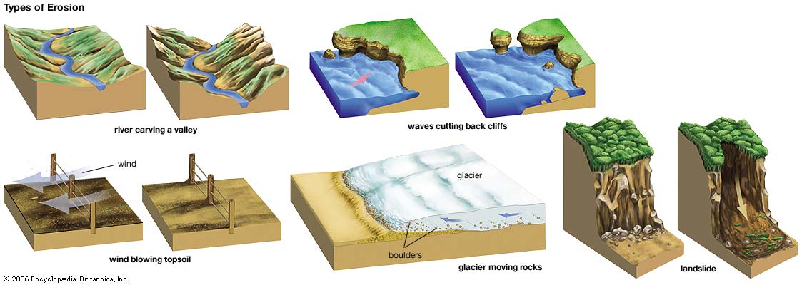
Erosion
Erosion is the process by which soil and rock are removed from the Earth's surface by natural processes such as wind or water flow, and then transported and deposited in other locations.
Types of Erosion:
Splash Erosion: Small soil particles are detached and sent airborne through the impact of raindrops on soil.
Sheet Erosion: Raindrops break apart the soil structure and it's moved down-slope by water that flows overland as a sheet rather than definitive channels. This occurs frequently during cloud bursts.
Rill Erosion: This process develops small, short-lived, concentrated flow paths. These paths create a sediment source and delivery system for hill-slope erosion. Areas where precipitation rates exceed soil infiltration rates are more prone to this type of erosion.
Gully Erosion: Water flows in narrow channels during or directly following heavy rains or melting snow. The gullies can erode to considerable depths.
Valley or Stream Erosion: Continual water flow alongside land (along a linear feature) creates this type of erosion. It extends downward, deepening a valley, and head-ward, extending the valley into the hillside. This occurs most frequently in times of flooding.
Bank Erosion: Over time, banks of rivers and streams are naturally worn down.
Freezing and thawing: Cold weather causes water trapped in tiny rock cracks to freeze and expand, breaking the rock into several pieces.
Wind erosion is a major geomorphological force, especially in arid and semi-arid regions. Wind erosion is of two primary varieties: deflation, where the wind picks up and carries away loose particles; and abrasion, where surfaces are worn down as they are struck by airborne particles carried by wind.
Mass movement is the downward and outward movement of rock and sediments on a sloped surface, mainly due to the force of gravity. Mass movement is an important part of the erosional process, and is often the first stage in the breakdown and transport of weathered materials in mountainous areas. It moves material from higher elevations to lower elevations where other eroding agents such as streams and glaciers can then pick up the material and move it to even lower elevations. Mass-movement processes are always occurring continuously on all slopes; some mass-movement processes act very slowly; others occur very suddenly, often with disastrous results.
Source: (water)
**Logging requirements**
DO NOT POST ANSWERS IN YOUR LOG.
Send the following answers to me via email.
- The text "GC626NK Dolores Canyon overlook" on the first line
- Why is the top level cliff smooth and the others not as smooth? (Look at waypoint “erosion”)
- When looking at waypoint "erosion" which of the four distinct cliff levels is the most jagged?
- When standing at the scenic overlook point area, look at the rocks inside the walls, the ones you are standing on and around; are they smooth or jagged?
- Why are the rocks here different than where the smooth and jagged rocks are along the cliff faces, why would they not be the same?
Sources
- water: erosion. Art. Britannica Online for Kids. Web. 4 Sept. 2013.
- Gregory, L. (1996). Colorado scenic guide (3rd ed.). Boulder, Colo.: Johnson Books.
- http://www.aipg.org/Events/2009%20Annual%20Meeting/Unaweep%20Canyon%20Field%20Trip%20Guidebook.pdf
- https://nmgs.nmt.edu/publications/guidebooks/downloads/32/32_p0137_p0144.pdf
- http://coloradogeologicalsurvey.org/wp-content/uploads/2013/08/22.pdf
| I have earned GSA's highest level: |
   |