The geology of Anglesey is notably complex and is frequently used for geology field trips by schools and colleges. Younger strata in Anglesey rest upon a foundation of very old Precambrian rocks that appear at the surface in four areas: a western region including Holyhead and Llanfaethlu a central area about Aberffraw and Trefdraeth an eastern region which includes Newborough, Gaerwen and Pentraeth a coastal region at Glyn Garth between Menai Bridge and Beaumaris. These Precambrian rocks are schists and phyllites, often much contorted and disturbed.
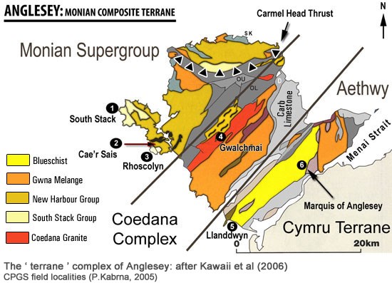
The general line of strike of the formations in the island is from north-east to south-west. A belt of granitic rocks lies immediately north-west of the central Precambrian mass, reaching from Llanfaelog near the coast to the vicinity of Llanerchymedd. Between this granite and the Precambrian of Holyhead is a narrow tract of Ordovician slates and grits with Llandovery beds in places; this tract spreads out in the north of the island between Dulas Bay and Carmel Point. A small patch of Ordovician strata lies on the northern side of Beaumaris. In parts, these Ordovician rocks are much folded, crushed and metamorphosed, and they are associated with schists and altered volcanic rocks which are probably Precambrian.
Between the eastern and central Precambrian masses Carboniferous rocks are found. The Carboniferous Limestone occupies a broad area south of Lligwy Bay and Pentraeth, and sends a narrow spur in a south-westerly direction by Llangefni to Malltraeth Sands. The limestone is underlain on the north-west by a red basement conglomerate and yellow sandstone (sometimes considered to be of Old Red Sandstone age). Limestone occurs again on the north coast about Llanfihangel and Llangoed; and in the south-west round Llanidan on the border of the Menai Strait. Puffin Island is made of Carboniferous Limestone.
Malltraeth marsh is occupied by Coal Measures, and a small patch of the same formation appears near Tal-y-foel Ferry on the Menai Strait.
A patch of rhyolitic/felsitic rocks form Parys Mountain, where copper and iron ochre have been worked.
Serpentine (Mona Marble) is found near Llanfair-yn-neubwll and upon the opposite shore in Holyhead.
There is abundant evidence of glaciation, and much boulder clay and drift sand covers the older rocks.
Patches of blown sand occur on the south-west coast forming a spectacular dune landscape.
Under the name GeoMôn, and in recognition of its extraordinary geological heritage, the island gained membership of the European Geoparks Network in spring 2009. and the Global Geoparks Network in September 2010.
There are Google Earth files: Anglesey.kmz and Anglesey.kml, which show important geological locations on Anglesey, and include a number of geological map overlays, they can be downloaded from: Google Earth Geology, whereas a historiography of geological research on Anglesey is available at: Historiography of Geological Research.
To log this Earthcache you will need to visit the co-ordinates and email me the answers to the following questions (any armchair logs will be deleted)
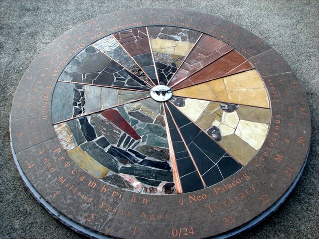
1. Who constructed the Rock Clock?.
2. On the table clock, name the rock, at 3 o'clock with the red background, then locate the that same rock on the clock face on the ground, and describe its colour and texture.
3. Name 2 of the rock types at 13.00hrs
4. What time is Felsite?
Please do not post answers in your log. Photos will be very welcome!
For those with a real interest in Geology click on the related web site link at the top of the page which will take you to a very educational link to the British Geological Survey website. This gives an excellent account of some of the Geological history of Anglesey