EDUCATIONAL LOGGING REQUIREMENTS
In order to substantiate your visit and comply with the educational requirement for Earth Caches you have to submit your answers to the following questions to the cache developers via their profile:
For purposes of logging this cache you must answer the following five questions.
1) Describe the granite you are standing on (colour and surface)
2) What are the large crystals in the granite?
3) What are the two sedimentary layers on the peninsula?
4) What rock forms the hills on the point of the peninsula?
5) How may blocks of granite make up the pedestal that the Geological Society Plaque is mounted on? Do you think the granite is Seeberg granite? Explain your answer. (Locational question)
|
The Seeberg viewpoint is located on exposures of the coarse-grained porphyritic Seeberg Granite along the north eastern shores of Langebaan Lagoon. The granite crystallised deep within the crust at the beginning of the Cambrian Period some 540 million years (uranium-lead radiometric dating) ago. This granite contains numerous crystals of white feldspar crystalized during slow cooling of the magma at a depth of a few kilometres. These crystals are clearly visible when walking from the parking to the published coordinates.
Across the lagoon, the hills forming the northern part of the Langebaan Peninsula consist of ignimbrite, a pyroclasitic rock made of hot volcanic ash ejected from fissures approximately 515 million years ago and deposited at such a high temperature that the edges of the constituent grains fused together. These ignimbrites are the only volcanic rocks described from the Cape Granite Suite and represent the youngest rocks within the Suite. The welded ignimbrite deposit is underlain by coarse grained granite.
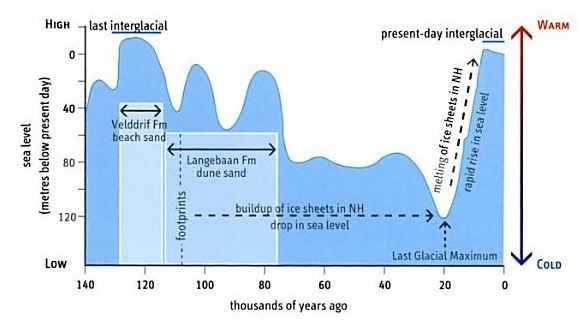
Overlying the Cambrian bedrock in this area is a geologically young sedimentary succession of weakly cemented rocks deposited during changes in sea levels. In the cliffs south of Kraalbaai, the rock comprises burrowed lagoonal sand overlain by horizontally laminated beach sand of the Velddrift Formation, which is about 130,000 to 120,000 years old (late Pleistocene). This sequence is overlain by cross-bedded, cemented dune sands (calcified sand dunes) of the Langebaan Formation, which is approximately 117,000 years old and contain footprints of an early modern human. Sea levels subsequently fell by as much as 130 meters during the Last Glacial Maximum, when, some 20,000 years ago, ice sheets extended over much of Northern Eurasia and North America. The lagoon would have been left high and dry, tens of kilometres from the sea at this time.
As the ice sheets melted and the sea rose again to a level around 3 m higher than today approximately 6-7 thousand years ago, two tidal inlets allowed flooding of Langebaan Lagoon, one south of Saldanha Bay and a second west of Kraalbaai. The cliffs south of the Pulpit Rock (Preekstoel), on the western side of the lagoon, began eroding away at this time, when sub-tidal channels in the lagoon hosted extensive oyster colonies.
The chart below illustrates the sea levels over the period of the formation of the sedimentary layers.
The exposed cliffs at Kraalbaai clearly show the two layers of rock. The darker rocks at the base are the Velddrift beach sands while the steeply cross-bedded white dune sand deposited are part of the Langebaan Formation.
Heaps (middens) of discarded mussel and limpet shells on the peninsula, up to 6 thousand years old, show that this has long been a popular spot for human visitors.
The modern microtidal (tidal variation less than 2 m) lagoon has developed since the closing of the Kraalbaai inlet, around 2 thousand years ago, when the sea level fell to its present level. The subtidal channels shallow from a depth of 17 m beside Langebaan towards Geelbek in the south, where they are flanked by wave-rippled intertidal sand-flats that are intensively burrowed by sand prawns. The elevated supratidal salt marshes are cut by sinuous drainage channels and host a rich carpet of multi-coloured, slat-loving succulent vegetation. At high tide, the subtidal channels appear dark blue, whereas the intertidal zone has a turquoise hue, a beautiful sigh on a fine day, with Table Mountain far to the south on the horizon.
To claim this earthcache as a find please send me an email with the answers to the five questions, your caching name and your email address through our profile.
You may log your find once you have visited the site and determined the answers to the questions. Logs not supported by the necessary email will be deleted. Please do not reveal the answers in your log but pictures are always welcome!
The information to answer the questions can be found by looking carefully at the stone and reading the description of the cache
References
The Geological Society of South Africa
Wikipedia
SANPARKS
Sawestcoast.com
The petrogenesis of the ignimbrites and quartz porphyritic granites exposed along the coast at Saldanha, South Africa - Joseph, Cedric S. A.
The Rocks and Mountains of Cape Town - John S Compton (Image)