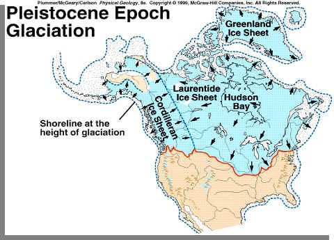
Quaternary (1.6million years ago to today) sediments are youngest deposits in Kentucky and are mostly restricted to the floodplains of rivers and creeks. Quaternary sediments consist mostly of silts, gravel, and clay eroded from Palezoic rocks exposed at the surface in Kentucky. However, some also contain rocks that were transported in to parts of Kentucky along the Ohio River Valley by meltwaters from glacial ice that covered much of eastern America north of the present day Ohio River during the first part of the Quaternary (called the Pleistocene Epoch or Ice Age).
High-level fluvial deposits
High-level fluvial deposits, shown as a dot-pattern of the geologic map, occur along the Kentucky, Ohio, Licking, and Green Rivers. Such names include fluvial deposits, terrace deposits, continental deposits, and gravel deposits. The unit includes generally unconsolidated sediments of Pleistocene and probably Pliocene age that occur some hundreds of feet above Holocene river deposits. These deposits, as much as 100 ft thick, are mapped as high as 400 ft above present river level. Unmapped scattered river gravels have been found even higher. They are composed of sand, silt, clay, and gravel. The sand is generally fine grained, yellowish to reddish brown, and quartzose; the silt and clay are commonly light brown or light gray. The gravel consists of rounded quartz and quartzite pebbles, cobbles, and boulders as much as 2 ft long and includes minor amounts of chert; quartz geodes are locally abundant. In some places, deposits are cemented by limonite. High-level fluvial deposits are, for the most part, composed of material derived from Mississippian and Pennsylvanian rocks of south-central Kentucky, augmented in places by locally derived clasts from older strata. They represent the remnants of dissected terrace deposits and channel deposits of abandoned river segments. Over part of the area, these deposits are referred to as the "Irvine Formation" or informally as the "Irvine gravel."

The Ohio River had followed this new course for a long period prior to the advent of the Illinoian glaciation. Along the Upper Ohio, Kanawha, and Allegheny, Leverett recognized an old gradation plain, both terraces and abandoned valley sections, 200-300 feet below the upland.5 These old valley floors here carry a pre-Illinoian drift, perhaps Jerseyan, and remnants of such gradation plains are recognized down the Ohio valley and along some of its tributaries as far as Hancock County. Diversion of the old drainage lines to form the Upper Ohio attended or followed this early glaciation and along the new course an inner valley was subsequently cut 200 feet or more below the level of the old. Illinoian drift is widely present along the new valley. To what extent it was regional uplift or the enlargement of the drainage area that caused the trenching is not clear but certainly the latter is at least in part responsible.
Now with question and answers. Please email the answers. If put in your log will be deleted.
1. The terrace deposits came about in the Quaternary. What period or epoch_________ and what age________?
2. At GZ, What is the depth of the deposits? What do you see? Tell me color and texture?
3. How deep is the deposit over the sandstone? (RP1111)
4. What is seen at (RS2222)?
5. By using (RS2222) give me the length of deposit? (go west)
6. Pic of yourself at the EC.