LA SENYERA
( Estirant les cames per Olesa I ) |
Primer catxé de la sèrie que us proporcionarà unes vistes inmillorables de la vila d'Olesa de Montserrat. Val la pena reposar una estona sota el roure o al costat de la Senyera i contemplar la vista que s'obre davant nostre.
Malauradament, tot el que veieu mai serà vostre, però les vistes no us les pot privar ningú!
English
First cache of the rute. There are a beautifull views of Olesa de Montserrat. You can rest for a while under the oak or next to the flag and admire the scenary.
Unfortunately, all that you see never will be your... but nobody can deprive this views.
_______________________________________________________________________________
|
Estirant les cames per Olesa
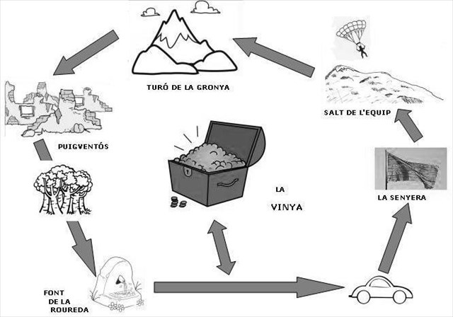
Us proposem una excursió per estirar les cames pels volts d'Olesa de Montserrat. Conteu que us faran falta entre dues i tres hores per fer aquest recorregut circular i que caldrà pujar i baixar per corriols prou drets. Porteu bon calçat i aigua, sobretot si el feu a l'estiu. El recorregut és circular, es pot fer en ambdós sentits, però us recomanem fer-lo tal i com s'indica, així no caldrà caminar de més per fer el Misteri Final: La Vinya. Recordeu que cal apuntar el codi corresponent a cada lletra que trobareu als cinc catxés de la sèrie per poder trobar la localització del catxé misteriós final La Vinya. Bona recerca!
El punt de partida i lloc per aparcar el cotxe serà l'explanada del darrera del Poliesportiu Municipal Salvador Boada (N41º33.276 E001º 53.444). A partir d'allà caldrà seguir pel camí de carro direcció al Pla del Fideuer (primer trencall a la dreta, seguint l'indicador). Pujarem per la pista fins a N 41° 33.599 E 001° 53.616 on, a mà dreta surt una pista forestal força deteriorada que seguirem pujant entre arbres i oliveres fent ziga-zagues. A N 41° 33.568 E 001° 53.763 s'acaba la pista i surt un corriol senyalitzat amb taques blanques. Cal seguir-lo en franca pujada fins al primer catxé: La Senyera (N 41° 33.604 E 001° 53.835).
Un cop trobat el catxé seguirem el camí que serpenteja seguint la cresta del turó fins arribar al segon catxé, al punt més alt i lloc d'enlairament de parapentistes, és el Salt de l'Equip (N 41° 33.745 E 001° 53.779).
Ara tocarà baixar tot resseguint el caminet arrant de tanca fins a connectar amb l'entrada de la vinya on acaba el corriol (N 41° 33.804 E 001° 53.807). Pujarem per la pista d'accés fins a contactar amb la pista forestal (N 41° 33.852 E 001° 53.833) i la seguirem cap a l'esquerra. A N 41° 33.875 E 001° 53.806 surt un corriol a mà dreta senyalitzat amb un indicador i marques blanques. Caldrà seguir-lo, és llargs i, a trams, puja de valent fins arribar al tercer catxé de la sèrie i punt més alt del recorregut: el Turó de la Gronya(N 41° 34.091 E 001° 53.877).
Un cop signat el registre, recularem uns metres i seguirem en direcció nord baixant per l'altre cantó del turó. Anirem fent fins acabar el corriol a N 41° 34.219 E 001° 53.958. Davant nostre hi tenim les runes del Mas de Puigventós. Aquí tornarem a fer una parada per cercar el quart catxé: Puigventós (N 41° 34.234 E 001° 53.969).
A Puigventós hi trobem una cruïlla de camins, nosaltres seguirem la pista forestal que baixa direcció Montserrat fins arribar a N 41° 34.235 E 001° 53.899. Som a la millor roureda del terme i des d'aquí un corriolet baixa pel dret enmig bosc. El corriol va fent ziga-zagues entre els arbres per acabar a una pista forestal (N 41° 34.336 E 001° 53.713). La seguirem de baixada, cap a l'esquerra. Ara ja no té pèrdua, cal seguir aquesta pista fins al final i tornarem a l'aparcament darrera el poliesportiu.
Abans, però, haurem de fer dues parades: la primera a la Font de la Roureda (N 41° 34.285 E 001° 53.618) on cal trobar el cinquè catxé i la segona en un punt misteriós on podreu cercar el "Misteri final: La Vinya" que posa punt i final a la sèrie.
|
|
English
We suggest a trip in Olesa de Montserrat. You will need two or three hours to make the round trip for steep roads. You need a good shoes and water for drink, especially if you walk in the summer. The route is circular, it can be done both ways, but we recommend doing it as indicated, so no need to walk over to the final Mystery. Remember that you need the code for each letter that you will found in the five caches of the series. Later, you can found the Final Mistery. Good research!
The starting point and parking place is behind the Salvador Boada Sports (N41º33.276 E001º 53 444). From there, will follow the dirt road towards the Plan Fideuer (first turning on the right, following the sign). Climb the trail up to N 41 ° E 001 ° 53 616 33 599. There, we turn right alung a path between olives and pines. In N 41 ° E 001 ° 53 763 33 568 finished the track and leaves a path marked with white spots. You follow him in frank ascent to the first cache: la Senyera (N 41 ° E 001 ° 53 835 33 604).
After finding the cache, we follow the path that follows the crest of the hill until the second cache where there are a point jump for paragliding. Is el Salt de l'Equip (N 41 ° E 001 ° 53 779 33 745).
Now, we down for the trail behind the fence. We arrive at the door of the crop ( N 41° 33.804 E 001° 53.807 ). Go up for the acces way and arrive at a new path ( N 41° 33.852 E 001° 53.833 ). We turn left.There are a path to the right in N 41° 33.875 E 001° 53.806. Is marked with a signal ( "Turó de la Gronya" ) and white marks. We walked up a long time and arrive at thirth cache: Turó de la Gronya( N 41° 34.091 E 001° 53.877).
We continue to the North: down the path for the other side ot the mountain. We arrive in front of a the farmhouse runes (N 41° 34.219 E 001° 53.958): Is Puigventós farmhouse. Near here, we find the fourth cachéPuigventós(N 41° 34.234 E 001° 53.969).
Situated at the crossroad, we follow the track that dawn direccion to Montserrat mountain. At N 41° 33.752 E 001° 53.773 there is a right way. We are in the oak forest amd the way finish in a road (N 41° 34.336 E 001° 53.713). We continue dawn to the left. The road arrive at parking area. Before, we stop at source and looking for the caché (Font de la Roureda, N 41° 34.285 E 001° 53.618).
With the codes found in the caches, we can looking for the final mystery cahe: La Vinya that finish the series. (The place of this cachés is before arrive to the parking). |
|