LOGGING REQUIREMENTS:
We encourage you to take a picture of yourself and/or caching team and post it on this cache page. To log this earthcache as a find, you must email the answers to the following questions to the cache owner:
1) Which native plant do you see thriving here that you wouldn't expect to see in wetter habitats.
2) Which two present day roads follow the same route as the old Sand Road?
3) Why did they build the road on scrub land?
4) How was scrub land formed?
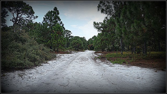

The Historic Sand Road in the Hypoluxo Scrub Natural Area
In the late 1800s, Dade County was a vast area that encompassed what are now Martin, Palm Beach, Broward, and Miami-Dade counties. At that time, Miami was known as Fort Dallas and served as the county seat. However, in 1889, the county seat and courthouse were relocated to Juno. Officials needed to travel frequently between Miami and Juno, but the only means of transportation were steamers or sailboats. Meanwhile, mail was delivered overland by barefoot mailmen, who walked along the beach—a time-consuming and dangerous task. Tragically, one mailman disappeared, likely falling victim to an alligator or shark while crossing one of the many rivers and inlets along his route.
In 1892, the Dade County Commission sought to create a more reliable connection between Juno and Miami. They authorized the construction of an 8-foot-wide sand road suitable for mule-drawn wagons. This road would link the south end of Lake Worth with the north end of Biscayne Bay, starting near present-day Hypoluxo and ending in Lemon City, which is now part of Miami. Although the exact path of the Sand Road is unknown, it is believed that parts of it eventually became the Dixie Highway and U.S. 1.
Travel along the Sand Road was slow due to the soft white sand, with speeds averaging only 2-3 miles per hour. Despite this, it was still faster than walking along the beach. The journey to Miami took two days. Travelers would cross smaller waterways, like the Hillsboro River, using bridges. It took about 14 hours to reach the New River in Fort Lauderdale, where they would camp near the Stranahan House. The next day, they crossed the river by boat before continuing on a seven-hour ride to Miami.
The Sand Road was built along the natural sand ridge known as the coastal scrub, which runs adjacent to the barrier islands along the peninsula. This ridge, formed when sea levels were higher, provided a stable, well-drained route with a low risk of flooding. Over time, scrub areas became desirable for development due to their dry conditions. The Hypoluxo Scrub Natural Area was nearly developed several times in the 1940s, 1950s, and 1960s. Today, less than 2% of the original scrub habitat remains in Palm Beach County.
You can still walk the northernmost portion of the historic Sand Road, located within the Hypoluxo Scrub Natural Area. This section of the road, which remains sandy, has never been built on and was only lightly used for agriculture. Now, vegetation is slowly reclaiming the road, though service vehicles still use it. Take a walk through the Hypoluxo Scrub area and experience a piece of Florida’s history. The park is open daily from sunrise to sunset, and admission is free.