 Español
Localización
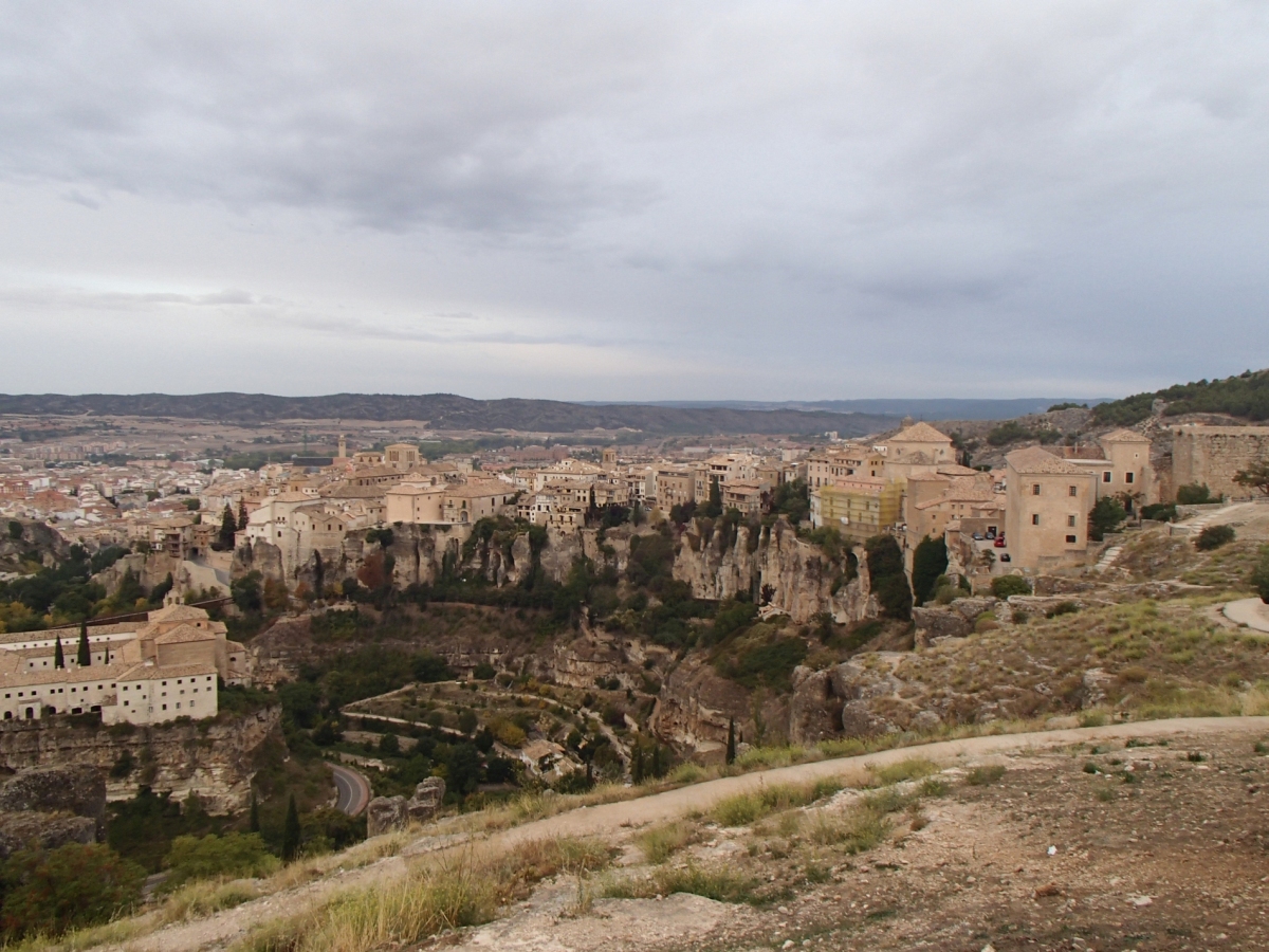
Karst o relieve kárstico, es un fenómeno natural que podemos apreciar muy bien en Cuenca. En las paredes rocosas del entorno de Cuenca se pueden observar dos capas diferentes: la parte superior de un color más oscuro y la parte inferior con tonalidades más claras. Sólo en la capa inferior la piedra caliza incorpora magnesio en su composición, lo cual genera un grave problema: con ayuda del magnesio, poco a poco, el agua de la lluvia va disolviendo la piedra calcárea. Como por su naturaleza la estructura de la capa superior es más fuerte, se van formando cornisas, que al final y por su propio peso irán cayendo. Algo que podrán ver con facilidad cuando observen las hoces desde cualquier mirador de la ciudad.
Geomorphology
Las formaciones Karst son el resultado de la disolución de rocas formadas por minerales solubles en agua. Este proceso está controlado inicialmente por la interacción de una fase sólida soluble (roca) y una líquida (agua), bajo condiciones geológicas favorables para la circulación del agua, el clima favorable (temperaturas y precipitaciones) y el tiempo necesario, el proceso de formación Karst se producirá en la superficie y en el sub-suelo. La disolución de rocas solubles con las condiciones antes mencionadas crea una característica y muy espectacular morfología típica de la exokarst y la endokarst. El modelado kárstico origina muchos elementos de relieve diferentes que resultan en una gran diversidad morfológica, desde micro y meso formas (encauzamientos, surcos y cavidades - lapiaz o lenars), a macro formas (cañones kársticos, poljes, dolinas). En este sentido, los procesos kársticos no se limitan sólo a la superficie (exokarst), si no que su desarrollo subterráneo es tal vez más importante y, sin duda, más espectacular, ya que crea cuevas, canales, sumideros y una variedad de estructuras de disolución-precipitación (endokarst).
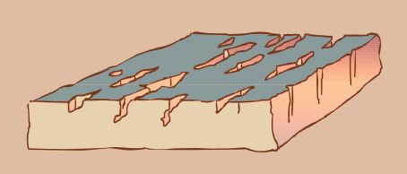
La formación de un lapiaz se puede resumir en tres etapas:
1)En una primera etapa el agua circula sobre las dolomías y va agrandando por disolución una serie de fracturas o líneas dedebilidad existentes, formándose una serie de surcos alargados que llevan la misma dirección.
2) Según va evolucionando el lapiaz, los surcos se van ensanchando por disolución de la roca formando pasillos y callejones.
3) Según progresa la disolución, estos callejones pueden llegar a unirse creando un paisaje laberíntico muy curioso y singular. Sólo algunos relieves residuales quedan como testigos de la formación rocosa desaparecida.
Para registrar este earthcache, enviame un correo electrónico con las respuesstas para las siguientes preguntas:
1) ¿En cual de las tres fases piensas que se encuetra este paisaje karst?
2) Mirando a Cuenca, a tu izquierda, a pocos metros, puedes ver unas estructuras karst muy caracteristicas (con foma de seta). ¿Cuantas son? Dime la altura (aproximada) de la mayor, en tamaño, desde la base
3) ¿Cuanto mide el "cañon" a la "seta" mas cercana?
4) Añade una fotografia tuya en el local, u otra en la que se pueda ver algún objeto, o tu nick en un papel
- Si piensa que a concluido con exito los objetivos de esta Earthcache y ya me envio todas las respuestas según lo pedido, por favor, proceda a logar el cache como encontrado, despues verificare las respuestas enviadas,y si es necesario, contactare con usted para efectuar las correcciones oportunas a su registro.
-Todos los logs sin respuestas seran apagados sin aviso.
English
Location
Karst or karstic relief, is a natural phenomenon that we see very well in Cuenca. In the rocky walls of the environment Cuenca you can see two different layers: the top of a darker color and the bottom with lighter shades. Only in the lower layer includes magnesium limestone in its composition, which creates a serious problem: using magnesium, gradually, the rain water dissolves the limestone. As by its nature the structure of the upper layer is stronger, cornices are forming, in the end by its own weight and they will fall. Something that you can see easily when they see the gorges from any viewpoint of the city.
Geomorphology
Karst modeling is the result of water disolving rocks formed by soluble minerals. This process is initially controlled by the interaction of a soluble solid phase (rock) and a fluid one (water), under favorable geolog-ical conditions for water circulation, favorable climate (temperatures and rainfall) and the necessary time for the karst process to take place on surface and in depth. The dissolution of soluble rocks with the afore-mentioned conditions creates a characteristic and very spectacular morphology, typical of the exokarst and the endokarst. Karst modeling originates many different relief elements resulting in a great morphological diversity, from micro and mesoforms (channelings, grooves and cavities – lapiaz or lenars), to macroforms (karstic canyons, poljes, dolines). In this sense, karst processes are not only limited to the surface (exokarst), but its underground development is perhaps more important and undoubtedly more spectacular, as it creates caves, channels, sinkholes and a variety of dissolution-precipitation structures (endokarst)..
The formation of karst landforms it´s a three-part process:
1) First, water circulates over dolomite rock, gradually dissolving it by working away at a series of already existing fractures or weak points. This results in a series of elongated parallel fissures.
2) As the karst topography develops, these grooves expand as the rock is worn away, and narrow passageways are formed.
3) As the rock continues to erode, these passageways can become interconnected, creating an interesting sort of labyrinth. In the end, only a few protrusions remain—witnesses to rock formations which no longer exist.
To log this earthcache, send me an email/message with the answer to the following questions:
1) In which of the three phases you think it´s this karst landscape actually?
2) Looking At Cuenca, to your left, a few meters along, you can see a very characteristic karst structures (mushroom form). How many they are? See the biggest one: How tall is it?
3) How long is the "canyon" to the nearest "mushroom"?
4) Add a photo of yourself at the place, or another in which you can see an object, or your nick on a piece of paper
-If you believe you have successfully completed this Earth Cache goals and has already sent to me all the requirements as requested, Please, feel free to log it as found. Later i will verify the requirements sent and, if necessary, contact you in order to make the necessary corrections to your log.
-Logs without answers, will be deleted without notice.