IL BACCHIGLIONE: COME E DOVE NASCE
Il Bacchiglione (Latino Medoacus minor) è un fiume del Veneto lungo 118 km che scorre nelle province di Vicenza e di Padova.
Il fiume nasce da alcune risorgive nei comuni di Dueville e di Villaverla (VI), prendendo inizialmente il nome di "Bacchiglioncello". Poco a monte della città di Vicenza riceve le acque provenienti dal sottobacino del Leogra-Timonchio (che scende dal monte Pasubio) e assume il nome di Bacchiglione.
In località Ponte del Bò a Maddalene riceve il torrente Orolo e a Vicenza riceve da destra le acque del fiume Retrone e da sinistra quelle del torrente Astichello. Altri tributari giungono da sinistra a sud est del capoluogo: il fiume Astico-Tesina e il Ceresone. Dopo Selvazzano Dentro il fiume entra canalizzato nell'area urbana di Padova attraversando canalizzato tutta l'area sud della città da ovest a est.
Nel tratto vicentino presenta un andamento ricco di meandri e anse mentre nel tratto padovano presenta una fisionomia differente con un corso rettilineo, in seguito ai numerosi interventi dell'uomo.
Il corso totale del fiume è lungo circa 118 km ed ha un bacino di raccolta che si estende per 1400 km².
Il fiume è soggetto a piene autunnali e primaverili, talvolta anche disastrose.
Sfocia nel mare Adriatico.

I PROBLEMI A VICENZA: LE ALLUVIONI
ALLUVIONE DEL 2010
L'alluvione del Veneto del 2010 si è verificata a seguito di una forte perturbazione di origine atlantica che ha portato sulla regione persistenti piogge a partire dal 31 ottobre 2010. A questo si è aggiunto anche il vento caldo di scirocco che, oltre a sciogliere la neve caduta sulle montagne le settimane prima, ha impedito il normale deflusso dei fiumi in mare Adriatico.
Il 20% della città è stato invaso dall'acqua del Bacchiglione e del Retrone. Il primo fiume è esondato nelle prime ore del mattino del 1º novembre colpendo la zona della chiesa dell'Araceli vecchia e di viale Rumor con il vicino parco Querini, trasformato in acquitrino.
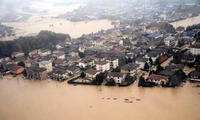
Conseguentemente la sede provinciale della Croce Rossa e dell'UNICEF site in contrà Torretti vengono fatte evacuare. Alle 7:30 il Bacchiglione esce anche a ponte degli Angeli bloccando l'accesso nord ed est al centro storico, tuttavia viene risparmiato il Teatro Olimpico grazie all'attivazione di tre idrovore (aggiuntesi alla due sempre presenti nella celebre struttura palladiana). Vengono invase dall'acqua anche contrà San Pietro, corso Padova, via IV novembre, le contrà lungofiume delle zone San Biagio/San Marco e la zona dello Stadio Menti. Il Bacchiglione esce anche nel ponte di viale Diaz bloccando il traffico su una delle principali arterie della circonvallazione esterna, allagando il quartiere di San Paolo (palasport, piscine, campo di atletica) e dei Carmini con la parte nord di corso Fogazzaro. Anche la zona di Santa Bertilla (dogana e mercato ortofrutticolo) viene allagata così come la zona di viale Trento.
Nel pomeriggio il Retrone esce invece nel quartiere S. Agostino e tutti i residenti dei piani terra del quartiere Debba vengono fatti evacuare. Il traffico in città risulta paralizzato: l'autostrada A4 viene chiusa così come la Tangenziale Sud e tutte le linee ferroviarie che partono o passano per la città. Anche le linee autobus della mobilità urbana di AIM subiscono variazioni ed alcune linee vengono soppresse per l'impossibilità di transitare per le vie cittadine. Ventun cabine elettriche finiscono sott'acqua, lasciando senza energia oltre 3.000 utenze.

Appena le acque si ritirano il sindaco Achille Variati lancia un appello ad eventuali volontari che possono dare una mano alla città e ai vicentini per tornare presto alla normalità. Il giorno successivo si presentano in più di 200 per fornire aiuto, prima agli uomini di AIM Valore Ambiente per ripulire le strade e poi ai cittadini. In quattro giorni i volontari raggiungono il numero di 2.483 persone che, in tre turni giornalieri con ritrovo in piazza Matteotti, vengono smistati nei punti più critici della città. Il 3 novembre vengono riaperte quasi tutte le scuole e viene confermato il consueto mercato cittadino del giovedì; nella stessa giornata arriva a Vicenza Guido Bertolaso che dichiara lo stato di crisi e fa giungere in città l'esercito.

L'11 novembre il Presidente della Republica arriva a Vicenza. Ecco un pezzo del suo discorso: « Avete dimostrato che non è vero che state ad aspettare gli aiuti dello Stato, che non chiedete ma fate, che avete capito come in un momento come questo pulire è un lavoro nobile. Nessuno si è vergognato di mettere le mani nel fango e di usare la scopa », tutti i volontari saranno ricordati come gli "angeli del fango".
COME LOGGARE LA CACHE
- Dove nasce il fiume? E che nome prende all'inizio? Quando si può chiamare "Bacchiglione?
- Dove sfocia?
- Quali sono state le cause dell'alluvione del 2010?
- Recati al primo stage, ti troverai sul Ponte degli Angeli. Stima quanto è largo il Bacchiglione da una sponda all'altra.
- Sempre nell'area del primo stage, vedrai un lungo metro bianco attaccato lungo la parete di un edificio, con quello saprai il livello dell'acqua.
- Stima la velocità dell'acqua
- Recati sia allo stage A che al B. In ognuno troverai una targa con una data e una linea. La data indicata l'anno dell'alluvione e la linea indica dove arrivava il livello dell'acqua durante l'alluvione. Che data è scritta nel waypoint A? E nel B? A quanti metri arrivava l'acqua dal suolo (in entrambi i waypoint)?
ENGLISH
THE BACCHIGLIONE: HOW AND WHERE IS BORN
The Bacchiglione (Latin Medoacus minor) is a 118 km long river of Veneto flowing in the provinces of Vicenza and Padua.
The river originates from some springs in the towns of Dueville and Villaverla (VI), initially taking the name of "Bacchiglioncello". Just upstream of the city of Vicenza receives water from the sub-Leogra Timonchio (which descends from Mount Pasubio) and took the name of the Bacchiglione.
In Ponte del Bo at Maddalene he receives the stream Orolo and Vicenza receives from the right the waters of the river Retrone and left those of the stream Astichello. Other tributaries come from the left to the south east of the capital: the river Astico-term paper and Ceresone. After Selvazzano Inside the river enters channeled in the urban area of Padua channeled through the entire area south of the city from west to east.
In the section Vicenza with a performance full of twists and turns and loops while the stretch from Padua has a different appearance with a straight course, following numerous human interventions.
The total course of the river is about 118 km long and has a catchment area that covers 1,400 square kilometers.
The river is prone to floods in autumn and spring, sometimes disastrous.
Joins the Adriatic Sea.
PROBLEMS IN VICENZA: FLOODS
FLOOD OF 2010
The flooding in the Veneto region in 2010 occurred as a result of a strong perturbation of Atlantic origin that led the region persistent rains from 31 October 2010. To this was added also the hot sirocco wind that, in addition to dissolve the snow falling in the mountains the weeks before, has prevented the normal flow of the rivers in the Adriatic Sea.
20% of the city was flooded by water Bacchiglione and Retrone. The first river overflows in the early morning hours of November 1, hitting the area of the church dell'Araceli old and Rumor avenue with the nearby park Querini, turned into marsh.
Consequently, the provincial headquarters of the Red Cross and UNICEF site in Contra Torretti are made evacuate. At 7:30 the Bacchiglione out also bridged the Angels blocking access north and east to the old town, but is spared the Teatro Olimpico thanks to the activation of three dewatering pumps (aggiuntesi the two ever present in the famous Palladian structure). Are invaded by water also contrà San Pietro, over Padua, Via IV Novembre, the Contra riverside areas San Biagio / San Marco and the area of the Stadium Menti. The Bacchiglione out on the deck of Viale Diaz blocking traffic on one of the main arteries of the outer ring road, flooding the neighborhood of San Paolo (stadiums, swimming pools, athletic field) and Carmini with the northern part of the course Fogazzaro. Also the area of Santa Bertilla (customs and vegetable market) is flooded as well as the area of Viale Trento.
In the afternoon the Retrone lets out in the neighborhood St. Augustine and all residents of the ground floor in the neighborhood Need to be evacuated. Traffic in the city is paralyzed: the A4 motorway is closed as well as the South Freeway and all railway lines that leave or pass through the city. Even the bus lines of the urban mobility of AIM remain unchanged and some lines are suppressed because of the inability to pass through the streets. Twenty substations end under water, leaving no power over 3,000 users.
As soon as the waters recede the mayor Achille Variati appeals to any volunteers who can lend a hand to the city and Vicenza to return to normal soon. The next day they have more than 200 to provide help before the men of AIM Value Environment to clean the streets and then to the citizens. In four days the volunteers reach the number of 2,483 people, in three daily shifts with meeting in Piazza Matteotti, are sorted in the most critical points of the city. November 3 are opened almost all schools and is confirmed the usual town market on Thursday; the same day arrives in Vicenza Guido Bertolaso declaring a state of emergency and the army is coming to town.
On November 11 the President of the Republic arrives in Vicenza. Here's a piece of his speech: "You have shown that it is not true that you are waiting for assistance from the State, but do not ask, you understand it at a time like this clean is a noble work. No one is ashamed to put their hands in the dirt and use the broom ", all volunteers will be remembered as the" mud angels ".
HOW TO LOG THE CACHE
- Where the river? It takes that name at the beginning? When you can call "Bacchiglione?
- Where it flows?
- What were the causes of the flood of 2010?
- Went to the first internship, you will find yourself on the Bridge of the Angels. Estimate how wide the Bacchiglione from one bank to another.
- Still in the early stages, you will see a meter long white attacked along the wall of a building, with that know the water level.
- Estimate the speed of the water
- Both went to the Stage A to B. In that everyone will find a plaque with a date and a line. The date given year of the flood and the line indicates where the water level reached during the flood.That date is written in the waypoint A? And in the B? How many meters the water coming from the ground (in both waypoints)?