Inspired by the geology, geomorphology and biogeography of Victoria, this garden will take you on a virtual tour of the state. It contains nearly 500 rocks of different sizes, shapes and type, with some nearly 14 tons and is embedded amongst vegetation endemic to Victoria. The first of its kind, it was designed primarily for use as an outdoor laboratory for undergraduate teaching and visiting school groups. It also provides a very pleasant relaxation space. If you come at night, you will get the bonus of some fantastic lighting! You can read more about the garden here.
All information can be obtained without leaving the designated paths or grassed areas in the rock garden. Within the rock garden, do not walk on any of the garden beds, especially the gravel garden beds as the plants are very fragile.
The starting coordinates will place you at an information board that contains some information about the garden as well as a map of the layout. This map provides site numbers for various locations, some of which you will need to visit to gather information to determine the final coordinates. However, I have included photos as well that will help you find your bearings.
Ephemeral marsh and cracking clay pan (Site 01)
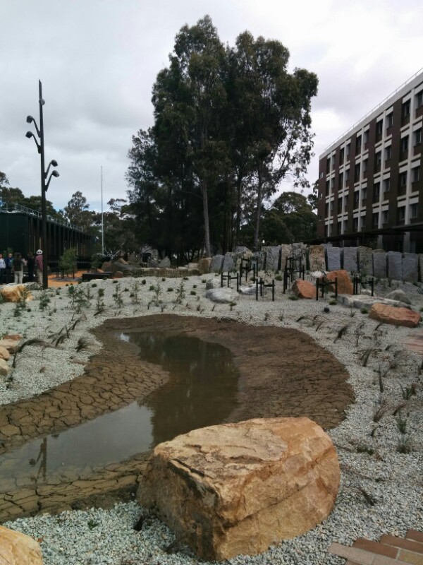
Very near to your starting point at the posted coordinates is a small ephemeral lake. Much larger ones can be found in parts of central and western Victoria. An ephemeral marsh or lake is one that receives water from rainfall only – no streams, creeks or rivers flow into the lake. They are usually dry and only contain visible water during and after rainfall. As these marshes dry, the clay lining them will contract, causing cracks to form in distinctly hexagonal shapes. When it next rains, the clay will absorb the water causing it to swell and the cracks disappear. Only once the clay is saturated will the lake begin to fill.
If this marsh is empty during your visit, you may see this hexagonally cracked clay. But you will be far more lucky if you happen to find it full! Please do not step into the lake if it's dry.
On the sign with the map next to the lake, count the number of hexagonal information plates. This number is A. Count carefully!
17 July 2025: Although it appears some plates are no longer there, the number remaining is still what is expected to answer the above question.
Sedimentary rocks of the Gippsland and Otway coasts (Site 05)

When you are standing at the map, directly behind you will see two types of rock that are common along parts of the southern Victorian coastlines as well as dune grasses and salt-tolerant trees such as banksia. The lighter coloured rocks were formed around 23 million years ago. If you look closely you can see small shells in these rocks that tell us that the sea-level has changed over time because, although these rocks contain sea shells, they were found well above the current sea-level. Geology tells us that the darker rocks were formed around 125 million years ago, when the Australian landmass was close to the South Pole. Look closely at a few of these darker rocks and you'll see that they contain remnants of something that provides evidence of what the landscape was like when the rock was formed.
Based on the evidence you found in the dark rocks, you can say that the landscape was likely,
- a marine environment as shells are present, then B=6
- a forested environment as charcoal is present, then B=5
- a damp mineralised environment, such as a cave, as crystals are present , then B=4
Plains of western Victoria with extrusive volcanic columns (Site 06)

Here you will find a number of outcrops of columnar basalt that are arranged in neatly fitting patterns, namely hexagons. These are naturally strong shapes that occur throughout nature – you may have already seen them in the clay pan. Columnar structures like these are found in many locations around the world like the Giant's Causeway in Ireland and they've even been identified on Mars!
The columns form their shape from hot magma that rises to the Earth's surface, where it forms lava that slowly cools and contracts to form the columns. These rocks are geologically young, those in the Organ Pipes National Park west of Melbourne are 'only' approximately 1 million years old.
The basalt here is also commonly known as bluestone and was a traditional material used around Melbourne to pave the streets and gutters and to build houses.
Using your compass, find the most south-westerly cluster of columns. How many columns are there in this cluster? This answer is C. (Hint: it's not the group of columns pictured.)
Regional fault line (Site 03)
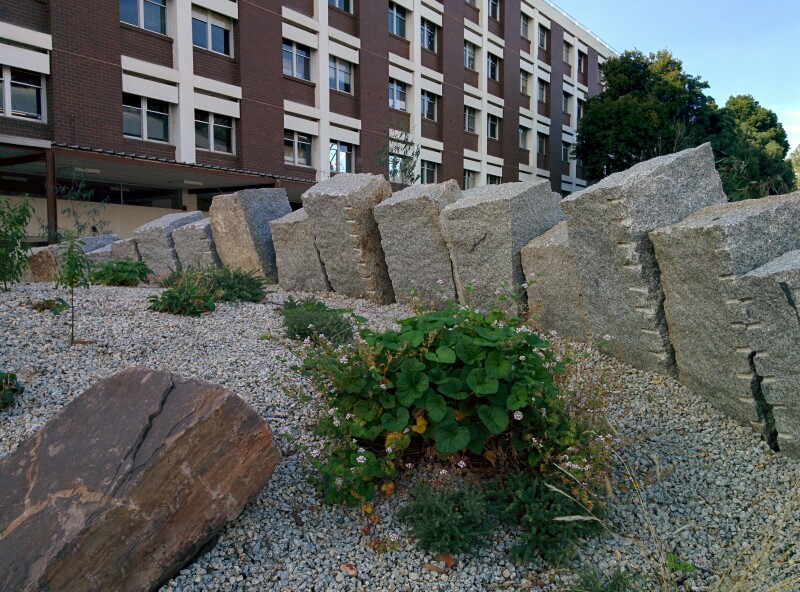
The two rows of granite blocks approximately in the centre of the garden represent a fault line that separates eastern Victoria from central Victoria. A fault line is a boundary where the area on one side of the fault has shifted relative to the area on the other side. This movement is a result of plate tectonic forces and is often manifested as volcanoes and earthquakes.
The granite here is a piece of evidence for mountain building and can be found scattered throughout the Great Dividing Range. The Great Dividing Range is estimated to be around 300 million years old and is not very high compared to younger mountain ranges like the Himalaya, reaching a peak of just 2228m at Mt Kosciuszko in New South Wales. This modest height is because the range is quite old by geological standards and has been subject to significant erosion.
Look at the changes in topography on either side of the fault line (east side and west side). If you assume that these two rows of blocks were originally aligned, how would you describe the main movement of the fault?
- vertical movement, then D=7
- horizontal movement, then D=6
- no movement, then D=5
Quartz and Victoria's Gold Rush (Site 07)
The 1850's Gold Rush of Victoria is well known from any Australian school's history class. If you look closely at the rocks at this site you can see veins of whitish, crystalline rock known as quartz.
Under high heat and pressure, minerals, including gold, dissolve into water deep in the Earth's crust, before travelling upwards toward the surface and into fissures within the surrounding, harder rock. Near the surface, the mineral-rich water cools and the minerals in the water deposit and re-crystalize, leaving the quartz and, very occasionally, dense concentrations of gold (e.g. nuggets) and other minerals embedded in the quartz. But don't get too excited: finding gold deposits in quartz is rare and the rocks in these gardens don't contain any.
Based on your knowledge of the history of the Victorian Gold Rush, in which of these Victorian towns would you be most likely find rocks like these?
- If it's Mildura then E=3
- If it's Mallacoota then E=5
- If it's Bendigo then E=7
- If it's Port Fairy then E=9
Future rocks? Lava bombs of the Anthropocene (Site 11)

Embedded among the red scoria rocks and the black lava bombs from an 8,000 year-old volcano near Colac in south-western Victoria are a number of unusual egg-shaped rocks that have a light-coloured 'centre' surrounded by a dark exterior. The designers of the garden had them specially created and have named them 'Anthropocenite', which means 'rocks from the the time of humans'.
Their idea is that over geologic time, the buildings surrounding you will have eroded and fallen into nearby creeks forming sediment. If a volcano then erupted underneath Monash University the chunks of this sediment would be violently ripped up and ejected as volcanic 'bombs'. The dark exterior of these 'bombs' is basalt lava that surrounds the lighter coloured centre, which is a sediment comprised of concrete and small pieces of other materials that are created by humans, like glass from computer monitors and rusted iron nails.
How many pieces of Anthropocenite can you see? This number is F. Note: search carefully for this one and consult the cache hint if necessary!
The hide is a short walk away at (S37° 54.(a+1)b(c/2) E145° 07.de(f+1)). Please take a little time to carefully return the cache so that it's correctly hidden.
You can check your answers for this puzzle on GeoChecker.com. If you need help, I strongly recommend you contact us by the email on our profile, rather than the message centre. you will likely get a much faster response.
As always, please be wary of muggles, especially during work days and during university semester! The cache is much, much easier on weekends and holidays.
Extra special thanks to
- SirJ-Oz for his help with part 6.
- darrent1974 for his alert on the cache being inaccessible and subsequent monitoring of the situation.
- sog12 for his help with restoring the cache to its original state.
Their generous and voluntary contributions are greatly appreciated. This cache is better because of their help!
FTF prize was a micro geocache in a fake rock container and was won by Riverbug Jam!
This cache was placed with permission and assistance from the School of Earth, Atmosphere and Environment, the School of Biological Sciences and the Faculty of Science. We are grateful for their help.