NOTE: This is an earthcache, there is no physical container to find at the coordinates. To get your smiley for the cache, e-mail your answers for the questions below to the cache owner. If you are arriving by cruise ship to the West Indian Company/Havensight dock and would like to walk it is a nice .7 mile walk from the port area.
The island of St Thomas is approximately 4 miles wide and 13 miles long. It is known for its picturesque mountain peaks, which tell a story of its geologic past.
Plate Movement:
Most of the world’s earthquake and volcanic activity takes place along its plate boundaries. At these plate boundaries the plates interact with each other in a variety ways; some plates slide past each other (Transform), others plates pull apart from each other (Divergent), and other plates move toward each other with crumpling or one dipping beneath the other (Convergent).

Caribbean Plate Movement:
During convergent plate movement the boundary where the two plates collide is called a subduction zone. Convergent plate movement is the main type of plate interaction occurring in the Eastern Caribbean. Specifically here the North American plate has slid underneath the Caribbean plate. This movement caused a series of volcanic events which formed most of the islands in the Virgin Islands.

These eruptions built up layers of lava and igneous rock over a period of 25 million years. Hilly islands such as St Thomas are actually peaks of submerged mountains formed by extinct volcanoes that have risen from a submarine plateau.

St Thomas's Geologic Past:
The island of St Thomas is one long ridge of hills which runs east and west. The capital is Charlotte Amalie which stands on a south slope of a wave of rock. Due to the hardness of this wave of volcanic strata peculiar hill spurs are seen in the backdrop of the town which gives St Thomas its picturesque appearance. A spur is defined as a lateral ridge or tongue of land descending from a hill, mountain or main crest of a ridge. The spurs or hills in this location are named from west to east: French Hill (aka Frenchman or Foretop), Berg Hill (aka Maintop), Bunker Hill (aka Black Beards Hill, Government Hill, or Mizzentop), and Blue Beards Hill. The coordinates for this earthcache are below Blue Beards Hill.

The spurs and shape of the harbor tell a story of Charlotte Amalie’s geologic past that it is actually the crater of an extinct volcano! Compared to the spurs which have higher elevation, the town is built on lower wave strata. From the town the stratum then dips down again into the harbor and is covered by water. Looking out to the south west from the town, evidence of the strata wave can be seen rising again forming Hassel Island. Due to the protection by Hassel Island and the spurs to the north, The Saint Thomas Harbor maintains most of its deep volcanic crater indentation.

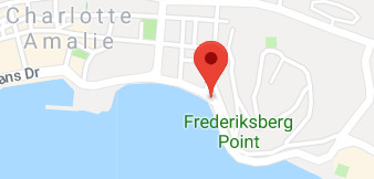
Frederiksberg Point:
The coordinates for this cache are at the base of Frederiksberg Point. Frederiksberg Point is a cape. A cape is defined as a pointed piece of land that extends into a body of water. Capes usually cause a marked change in the coastline. Due to capes proximity to the coastline they are prone to natural forms of erosion, mainly tidal actions. Due to this reason capes have a relatively short geologic lifespan.
Now it is time for the questions. To get credit for the cache, please answer the questions below. When answering the questions do your best. It is more important that you learn a new concept about our earth and can apply your knowledge, rather than have a precise answer.
Questions:
1- Looking at the bay and then across the water to Hassel Island, describe the current shape of the volcano crater or the bay.
2- How do you believe the cape of Frederiksberg Point was formed?
3- Using the information above and your answers to the previous questions, on a scale of 1-5 (1 = low rate of erosion and 5 = high rate of erosion) rate what you believe the erosion level is of Frederiksberg Point.
Thank you for visiting this earthcache. Please send your answers to the above questions to the cache owner. In your "found it" log feel free to write about your experience, but don't include the earthcache answers. Thanks and we hope you enjoy beautiful St Thomas!

Sources:
http://oceanexplorer.noaa.gov/facts/plate-boundaries.html
http://www.uwiseismic.com/general.aspx?id=16
http://www.legvi.org/
https://en.wikipedia.org/wiki/Charlotte_Amalie,_U.S._Virgin_Islands
http://caribbeantectonics.weebly.com
https://en.wikipedia.org/wiki/Spur_%28topography%29
http://www.britannica.com/place/Saint-Thomas-island-United-States-Virgin-Islands
https://en.wikipedia.org/wiki/Cape_%28geography%29
The building of an island: Being a sketch of the geological structure of the By John T Quinn