Cache Across Maryland 2016
The Maryland Geocaching Society and the National Park Service welcome you to the 2016 edition of Cache Across Maryland! In commemoration of the 100th Anniversary of the National Park Service, the MGS and the NPS have joined together in presenting CAM 2016 in ten National Park locations throughout the state of Maryland. From the mountains of Western Maryland to the Atlantic Ocean, Cache Across Maryland 2016 will demonstrate that Maryland truly is “America in Miniature”.
This is one of ten geocaches placed in National Parks for Cache Across Maryland 2016. Each geocache contains a code which you will use to determine the location of the CAM 2016 Picnic to be held on May 14th. The code can be found under the lid of the cache container and on the inside front cover of the logbook. Don't forget to record this code! Any geocacher who has completed all ten CAM geocaches and attends the CAM Picnic on May 14th will receive a Certificate of Completion and a Cache Across Maryland 2016 Geocoin. We hope you enjoy a very special CAM 2016!

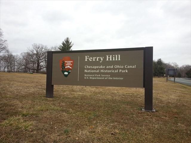
Chesapeake & Ohio Canal: Ferry Hill
The Chesapeake & Ohio Canal was a 184.5 mile canal that operated along the Potomac River from 1831 until 1924. The canal ran from Washington D.C. to Cumberland Maryland. Construction of the canal began in 1828 and was completed in 1850. The main purpose of the C&O Canal was the transferring of coal from the Allegheny Mountains. The canal consisted of 74 canal locks, 11 aqueducts, over 240 culverts and the Paw Paw Tunnel. The C&O Canal was supposed to go all the way to the Ohio River to connect up with Pittsburgh, but that part of the canal was never built.
By the 1870s, larger locomotives made shipping goods on the railroads cheaper than using the canal, and this started the decline of the canal use until it was shut down in 1924 in part due to severe flooding. The canal was obtained by the United States government in 1938 in exchange for a loan from the federal Reconstruction Finance Corporation.
President Dwight Eisenhower made the canal a National Monument in 1961, and the canal was made into a National Historic Park in 1971 by the passing and signing into law the Chesapeake and Ohio Canal National Historical Park Act. The accompanying towpath along with the canal provide a variety of outdoor activities including biking, boating, fishing, hiking, kayaking, running, and rock climbing. There are also several campsites along the towpath maintained by the National Park Service.
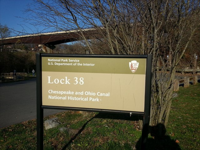
Lock 38 is located at a scenic part of Maryland. Across the Potomac River is the historic town of Shepherdstown, West Virginia. The road that connects Shepherdstown to Maryland heads into Washington County to the town of Sharpsburg and the Antietam Battlefield.
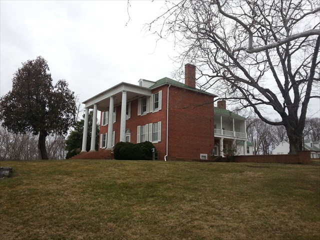
At the Lock 38 location is Ferry Hill Plantation. Ferry Hill was built in 1812 by John Blackford who had acquired the nearby ferry operations in an inheritance from Thomas Van Swearingen. John was looking at a perfect location for his farm in conjunction with the ferry service and picked this area to build the plantation. In 1833, John Blackford sold some of his land to the Chesapeake and Ohio Canal Company even though he continued to run the ferry operation. Ferry Hill Plantation passed through several owners in the 20th century including being the Headquarters of the Chesapeake & Ohio Canal National Historical Park from 1979 until 2001.
While on the C&O towpath, you may notice some old railroad pylons in the middle of the Potomac River. On top on one of these pylons is one of the most famous extreme geocaches in the entire country, Pyscho Urban Cache #13.
The Geocache
This geocache is not located at the listed coordinates. The listed coords will lead you to a footbridge crossing to the Canal Towpath. To determine the location of the geocache, you must first find three historical signs and gather information from those signs. While the signs may be found in any order, it would be most convenient to find them in the order listed below.
A parking waypoint (Parking 1) is given for the lot nearest Sign 1. It is recommended that you walk to Sign 2, as the nearest parking (Parking 2) has room for only seven cars. Use the Parking 3 waypoint to access Sign 3 and the final. Please do not attempt to walk to Sign 3; doing so would require crossing busy traffic on MD-34.
Sign 1: Lock 38 (N39° 26.002, W077° 47.707)
Using the “Facilities and Campsite Access” chart on the largest sign:
- A = the second digit in the mile of Huckleberry Hill
- B = the first digit in the mile of Big Slackwater
Sign 2: Blackford’s Ford (N39° 26.191, W077° 48.004)
- C = the third digit of the year Stonewall Jackson’s men splashed across the ford
- X = the date in July on which General Wallace delayed Early (answer in yellow box)
Sign 3: Ferry Hill (N39° 26.285, W077° 47.877)
- Y = the last digit in the number of acres of the plantation
- Z = the third digit in the year of John Blackford’s death
The geocache is located at N39° 26.ABC, W077° 47.XYZ
The checksum of ABCXYZ is 28.
The geocache is a clear lock-n-lock container.
The C&O Canal Historic Park at Lock 38 is open year round during daylight hours except on Thanksgiving Day, Christmas Day, and New Year's Day. There is no fee to enter the C&O Canal at Lock 38.
The Maryland Geocaching Society extends its thanks to the National Park Service for participating in Cache Across Maryland 2016 and for allowing us to partake in its centennial celebrations. Geocaches may only be placed on National Park Property at the direction of National Park Service staff.