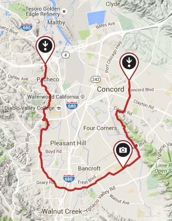
Contra Costa Canal Trail is a part of the East Bay Regional Park District.
Did you know that the East Bay Regional Parks District is the largest urban park system in the entire country? This geocache is part of the Passport to the East Bay Parks series.
There is one special geocache in each of the East Bay Regional Parks properties (except a few that don't allow geocaches.) At the time of this cache placement, the park district encompasses 199,000 acres. Please enjoy all the parks and trails, but please respect the Park rules.
Be sure to stamp your passport with the stamp provided in the geocache. Many of the Passport geocaches have blank passport booklets in the container. You can also download a Passport via Passport To The Parks
When you completely fill up your Passport, you can redeem it for a special prize. Of course, there is no cost for participating. For further information on the Passport series, see Passport To The Parks
Contra Costa Canal Trail (CCCT)
One of the most popular trails in the Park District system, this multi-use, whole-access trail (accessible to persons in wheelchairs) is a paved pathway suitable for bikers, runners and equestrians. Created through a cooperative effort by the Contra Costa Water District, the Bureau of Reclamation and the Park District, this trail provides a safe off-road corridor connecting Martinez, Pleasant Hill, Walnut Creek, and Concord

Meandering along the Contra Costa Canal, following a horseshoe-shaped path through central Contra Costa County, the trail intercepts a number of local parks in Pleasant Hill (Las Juntas Park), Walnut Creek (Larkey Park, Heather Farm Park), and Concord (Lime Ridge). It also makes important connections to a number of regional trails, including the California State Riding and Hiking Trail, Briones-to-Mt. Diablo Trail, and the Iron Horse Trail, and will connect with the Delta De Anza Trail when it is completed to Martinez.
The Bureau of Reclamation began building the canal in the 1930s to supply crop irrigation in what was then a rural area. The canal was completed following a delay during World War II.
For more info, see CCCT

This is a busy trail so be cautious of bicycles, runners and dogs.
The cache is located a short walk from Oak Grove Road with parking at a nearby side streets.
There is also parking at the end of Winton Drive off Treat.
Be stealthy when searching for this cache.
There are also many other caches on this trail to find if you continue to walk in either direction
Don't forget to stamp your passport with the stamp inside the cache container.
.
Congratulations to RV Crew, VirgoJams and KCSearcher for the FTF