An excellent example of this is the South Coast of Taranaki near Hawera which has extensive rocky beaches lined by high crumbling cliffs. It is a great place for geology, but you should be wary of the potential for cliff falls, especially after rain. To visit this cache follow the signs to Hawera then to Waihi beach from SH3. Park in the car park at the end of Denby Road. Follow the access track to the beach to observe the cliffs.
It is recommended you watch this video prior to attempting this earth cache. It will make your trip more interesting and informative and will assist you in completing some of the requirements of the cache.
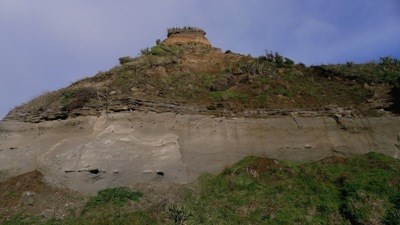
A first look at the cliff from a safe distance shows that it is made of two main rock types; massive grey muddy sandstone at the bottom, with darker brown soft stratified layers above. The boundary between the two layers is very distinct and can be seen for many kilometres along the coastline.
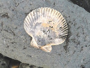
If you take a closer look at some of the muddy sandstone boulders lying on the beach, you can find some nice fossils such as this scallop:
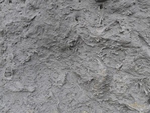
In places these rocks are very "bioturbated" which means they have been churned up by organisms that burrowed through them when they were part of the sea floor:
For a close up look at the boundary between the two layers that form these cliffs, a good place to go is waypoint1. There, just before you reach the beach, is an easily accessible outcrop where you can approach the boundary safely. You can observe the cliffs from the track to complete the requirements of the cache. If you do decide to cross the creek and view the cliff face close up you can do this with a bit of scrambling. Please exercise care though:
Here is a slightly closer view - you can see the change from the lower grey area containing oysters and scallops with the shell rich layers above. The fossils in the lower area indicate an environment of deposition about 20 to 50 metres deep. This layer is approximately 3.5 million years old:
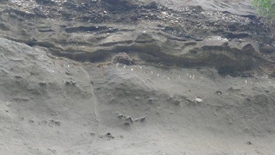
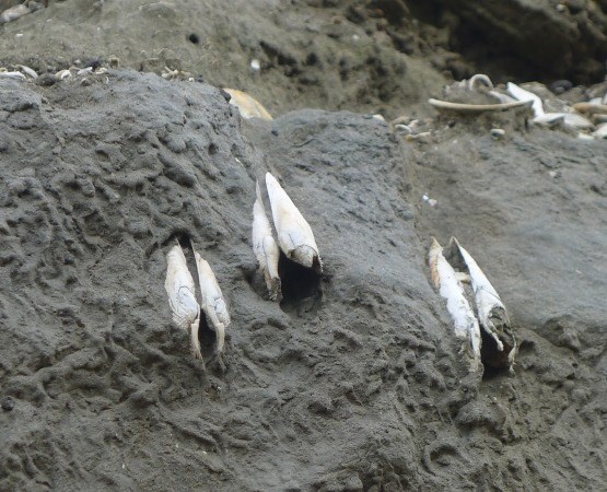
In the photo above, you can also see Just below the boundary there are some vertically positioned shells in a line. These have burrowed down into the sediment from above and have been preserved in life position. Although they are found within the 3.5 million year old sandstone, they are actually only as old as the overlying shelly layer, which is about 125 000 years old . Here is a closer view:
This means that the 3.5 million year sea floor sediment has been uplifted, eroded down to sea level, and then covered with shelly beach or estuarine deposits of much younger age. Nearly three and a half million years are missing from the sequence.
Interestingly the same unconformity is widespread across Taranaki. You can also can see it at Wai-iti Beach on the north coast. Here the time gap is even greater, as the underlying grey sediments are about 8 million years old and represent deposition at about 500 metres water depth. This shows that there has been greater uplift and erosion in the north compared to the south Taranaki coast.
Once you complete the EarthCache requirements you can post your find without delay, as per the EarthCache guidelines. You will also need to verify your find by sending us a message and provide your answers to these questions:
- Make sure you use the text "GC69C6M - Ancient Beaches - Waihi Beach" in your email
- Go to Waypoint 1. Observe the cliff face. How old are both apparent layers?
- Name the shellfish that appears vertically in the older grey muddy sandstone?
- Approximately how old are these shellfish?
- Observe the cliffs at Waypoints 1 and 3. Describe the difference in the layer above the older lower mudstone layer. In other words, what is present in one but not the other?
- At Waypoint 2 observe the larger boulders in the upper layer. Where are these most likely to have come from?
References:
GNS Science - http://juliansrockandiceblog.blogspot.co.nz/
Kyle Bland's - youtube video - "Fossils and tectonic uplift in Taranaki"