Localización
Una ría es un accidente geomorfológico que designa una de las formas que puede tomar el valle fluvial en torno a la desembocadura de un río, cuando un valle costero queda sumergido bajo el mar por la elevación del nivel de agua. Es un brazo de mar que se interna en la costa y que está sometido a la acción de las mareas. A diferencia de un fiordo, que es profundo y de escarpadas laderas ya que fue erosionado por un glaciar (se habla de profundización glaciar porque un glaciar es capaz de excavar por debajo del nivel del mar), una ría designa un valle no glaciar de un río costero inundado por la elevación del nivel del mar
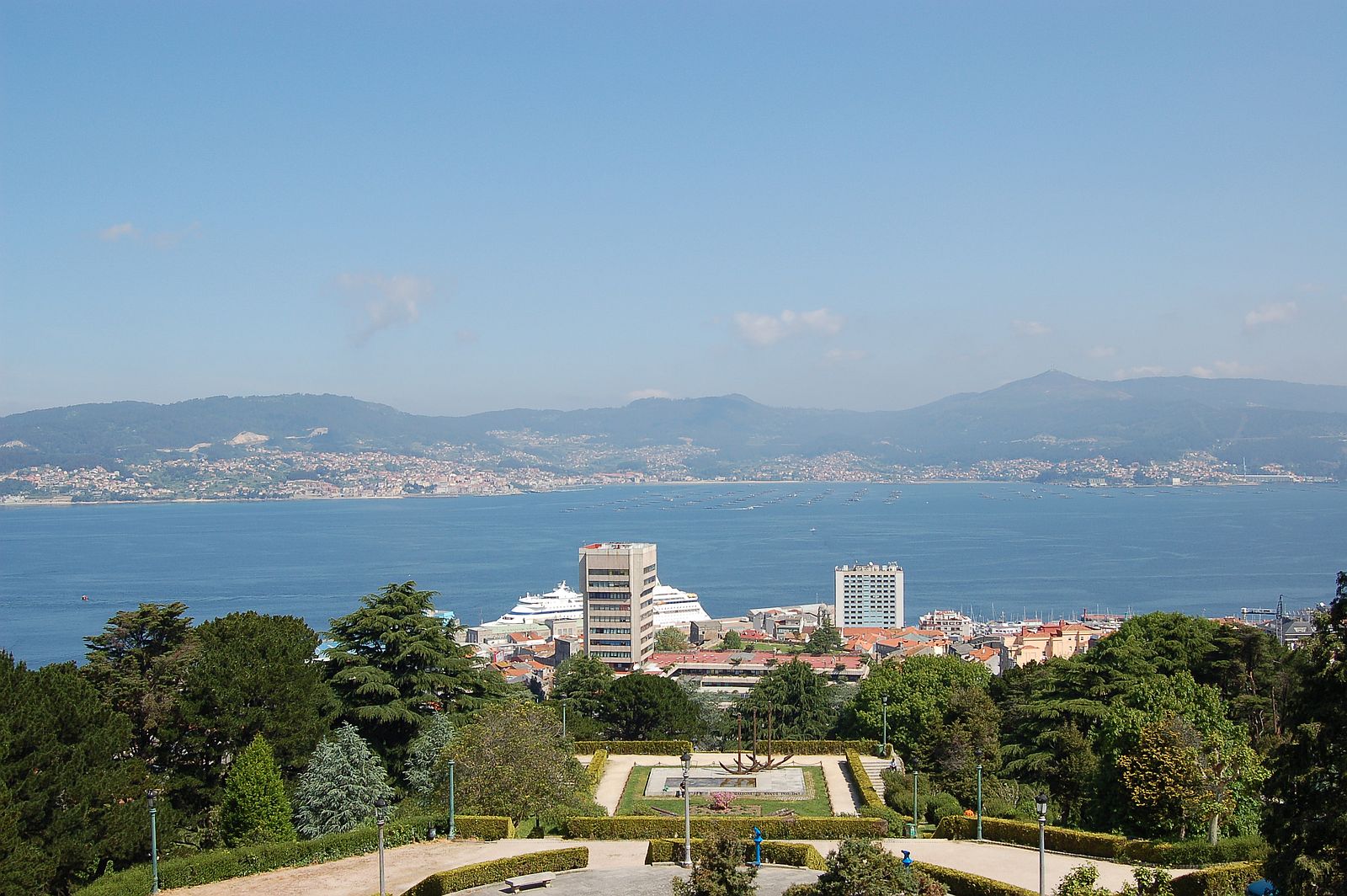
La Ría de Vigo posee unas características fisiográficas particulares, que a grandes rasgos consisten en una morfología en planta en forma de triángulo, un perfil transversal en forma de valle en artesa muy amplio, y un perfil longitudinal de suave pendiente hacia el mar. La boca de la ría, en su parte más ancha, alcanza entre 8 y 12 km de longitud. La parte interna es mucho más estrecha, con una longitud de entre 1 y 3 km. La topografía del fondo de la ría presenta un canal central con dirección NE-SO que alcanza profundidades de hasta 60 metros en la parte más externa, en su boca sur, mientras en la boca norte no se superan los 25 metros. La zona más angosta de la Ría de Vigo se sitúa en el Estrecho de Rande, en donde se registran profundidades de hasta 35 m. A partir de este punto y hacia el interior, en la Ensenada de San Simón, el fondo asciende rápidamente hasta alcanzar los 10 metros de profundidad, con una profundidad media en esta zona más interna de 7 metros, dando lugar al fondo a una extensa marisma
Geomorfologia
Desde el punto de vista geológico, la costa de Galicia se sitúa dentro del cinturón orogénico Hercínico. En la región de la Ría de Vigo, las formaciones sedimentarias recientes, de época Cuaternaria, son escasas y de poco espesor, y se corresponden principalmente con sedimentos de terrazas, llanuras mareales, marismas, playas y dunas. Éstas se desarrollan indistintamente sobre un sustrato de rocas ígneas y metamórficas, fundamentalmente granitos, gneises o esquistos. En relación a estos últimos, formados entre el Precámbrico y el Silúrico

En el mismo contexto tectónico del margen de Galicia descrito por Boillot y Malod en 1988, García-Gil et al. sugieren en 1999 que su morfología es una combinación de la existencia de fallas, responsables de los levantamientos regionales y locales, y de basculamientos de bloques tanto hacia el O-NO como al N-NE, así como de la erosión preferente a favor de dichas fracturas.
Los sistemas de fallas descritos parecen tener relación con la generación de seísmos en el NO de la Península Ibérica. La zona gallega suele presentar una actividad sísmica continuada. Desde finales de 1995 se han registrado seísmos de magnitud media, alcanzando 5.1 grados en 1997. Éstos parecen estar relacionados con las estructuras orientadas NE-SO, y en menor medida con las estructuras de dirección N-S. Estas orientaciones se reflejan de forma muy característica en la Ría de Vigo, cuya dirección principal es NE-SO, cambiando en la Bahía de San Simón a N-S debido a la intersección con una falla en esta dirección que recorre toda la vertiente atlántica de Galicia hasta el norte de A Coruña.
Los procesos tectónicos superpuestos al basamento Hercínico han dado lugar a la generación de importantes sistemas de fracturación, con unas orientaciones bien definidas en direcciones SO-NE, N-S y ONO-ESE. Algunas de estas fracturas fueron reactivadas durante el Mioceno-Plioceno, produciendo basculamientos de bloques que pueden haberse extendido hasta el período geológico más reciente del Cuaternario. Las hipótesis más aceptadas acerca del origen de las rías lo relacionan con la actividad tectónica asociada al levantamiento Alpino, a la erosión fluvial a favor de las fallas y al efecto de las variaciones cíclicas del nivel del mar.
Para logar este EarthCache, envíame un correo electrónico con la respuesta a las siguientes preguntas:
1) ¿Cual es el origen geologíco de la ria? Explica brevemente como se formo la ria
2) ¿Cual es la diferencia entre una ria y un fiordo?
3) En el punto 2: N 42 ° 13,907 W 008 ° 43,608, (90 metros detras de usted, viendo al mar)
Según el panel en frete de usted, ¿Como se llama el lugar mas lejano que puede ver desde aqui? ¿A que parte de la ria pertenece?
4) Añade una fotografia tuya en el local, u otra en la que se pueda ver algún objeto, o tu nick en un papel
-Si crees que as concluido con exito los objetivos de este Earth Cache, y me ha enviado todas las respuestas solicitadas, puede hacer el log. Luego yo comprobaré que son correctas, y si hay cualquier problema me pondre en contacto para arreglarlo.
-Logs sin respuestas enviadas previamente, seran borrados sin aviso
English (GoogleTranslate)
Location
An "ría" is a geomorphological accident that designates one of the ways you can take the river valley around the mouth of a river, when a coastal valley is submerged under the sea by the rising water level. It is a stretch of sea that goes into the coast and is subject to tidal action. Unlike a fjord, which is deep and steep slopes as it was eroded by a glacier (speaking of glacier deepening because a glacier is capable of digging below the sea level), a river designated a valley no glacier of a coastal river flooded by rising sea levels
"Ria de Vigo" has particular physiographic features, which broadly consist of a plant morphology in a triangle, a transverse profile shaped valley in broad trough, and a longitudinal profile gently sloping towards the sea. The mouth of the estuary, at its widest, reaches between 8 and 12 km in length. The inner part is much narrower, with a length of between 1 and 3 km. The topography of the river has a central channel with NE-SW that reaches depths of up to 60 meters in the outermost part, on its southern mouth while in the northern mouth not exceed 25 meters. The narrowest part of the Ria de Vigo is situated in the Strait of Rande, where depths are recorded up to 35 m. From this point and inward, in the Ensenada de San Simon, the fund is quickly reaching 10 meters deep, with an average depth in the innermost zone of 7 meters, leading the fund to an extensive salt marsh
Morphological classification
From a geological point of view, the coast of Galicia is within the orogenic belt Hercynian. In the region of the Ria de Vigo, recent sedimentary formations of time Quaternary, are slim and thin, and is mainly attributable to sediment terraces, tidal flats, salt marshes, beaches and dunes. They are developed either on a substrate of igneous and metamorphic rocks, mainly granites, gneisses and schists. Regarding the latter, formed between the Precambrian and Silurian
n the same tectonic context of the margin of Galicia described by Boillot and Malod in 1988, Garcia-Gil et al. suggested in 1999 that its morphology is a combination of the existence of faults, responsible for local and regional uprisings, and basculamientos block both to the O-NO as the N-NE, as well as the preferential erosion in favor of such fractures.
Fault systems described appear to relate to the generation of earthquakes in the NW of the Iberian Peninsula. The Galician area usually has continued seismic activity. Since late 1995 there have been earthquakes of medium magnitude, reaching 5.1 degrees in 1997. These appear to be related to NE-SW oriented structures, and to a lesser extent with the structures of N-S direction. These guidelines are reflected in a very characteristic in the Ria de Vigo, whose main direction is NE-SW, changing in the Bay of San Simon to NS due to the intersection with a fault in this direction that runs along the Atlantic coast of Galicia to north a Coruña.
Overlapping the Hercynian basement tectonic processes have resulted in the generation of significant fracturing systems with well-defined orientations in directions SO-NE, N-S and ONO-ESE. Some of these fractures were reactivated during the Miocene-Pliocene, producing basculamientos block may have spread to the latest Cuaternario.Las most accepted about the origin of the estuaries assumptions relate it to the tectonic activity associated with the Alpine geological survey period, to fluvial erosion in favor of the faults and the effect of cyclical variations in sea level.
To log this earthcache, send me an email with the answer to the following questions:
1) What it is the rias´geological origin? Explains very briefly as were formed
2) What it`s the difference between"ria" and fjord ?
3) In point 2: N 42 ° 13,907 W 008 ° 43,608, (90 meters behind you and watching the sea)
According to the panel in front of you, how do you call the place far away that we can see from here? What part of the "Ria" belongs?
4) Add a photo of yourself at the place, or another in which you can see an object, or your nick on a piece of paper
-If you believe you have successfully completed this Earth Cache goals and has already sent to me all the requirements as requested, Please, feel free to log it as found. Later i will verify the requirements sent and, if necessary, contact you in order to make the necessary corrections to your log.
-Logs without answers, will be deleted without notice.