La Promenade de Lennon et Luna
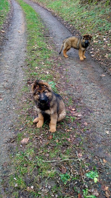
Cette cache vous amène à une courte promenade à travers la belle campagne du Charolais-Brionnaise. Si vous connectez le marche avec le cache „Les trois vieux Châtaigniers “ (GC69ZZV) , il sera un peu moins de 3 km. Sur cette chemin vous pourriez rencontrer Lennon et Luna, deux gentils chiens, qui choisissent cette chemin que l'une de leurs promenades préférées. Chacun d'eux a leur TB attachés à leur collier.
Vous pouvez garer votre voiture à N 46° 39.424' E 4° 00.588'. S'il vous plaît faire assurer que vous ne serez pas bloquer le passage ou l'entrée du pâture.
Attention! En cas de pluie le chemin devient très vite boueux !
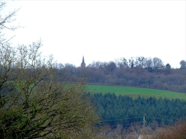
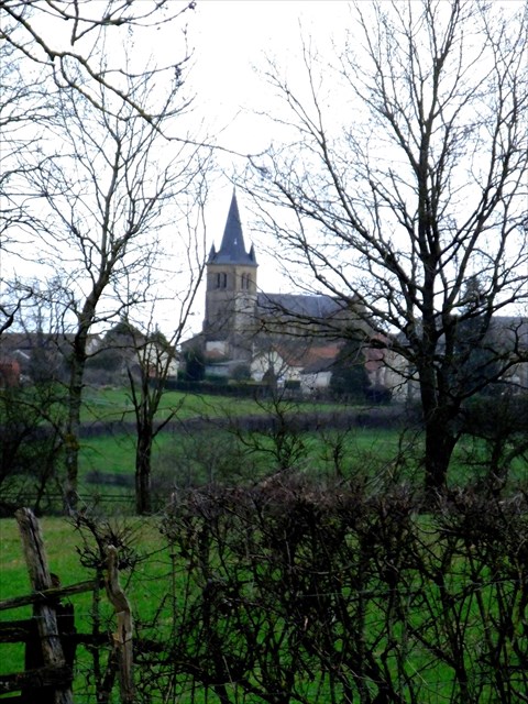
Cette voie est l'ancienne route de Uxeau à Bassenier. Sur la première partie de la chemin dont vous pouvez voir le clocher de l'église de La Chapelle-au-Mans dans la distance.
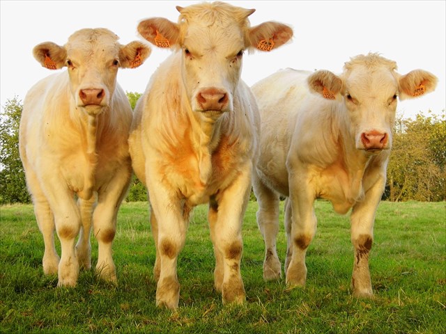
Il ya beaucoup d'animaux sauvages à voir ici. Parmi eux se trouvent des cerfs, des renards, des hérons, des buses, des corbeaux et des geais. Ainsi, vous trouverez des belles vaches charolais dans les pâturages.
Si vous regardez au nord, vous pouvez l'ami de Lennon et Luna, Gamin, l'âne, si vous avez de la chance.
En route, on a admiré le bocage du pays Charolais-Brionnais, territoire composé à 85% de prairies, soigneusement délimitées par des haies. Ce type de limite de domaine a été déjà utilisé par les Celtes et est une partie importante du patrimoine de la région. Depuis 2011, il a été demandé d'inscrire les bocages avec ses haies sous le patrimoine mondial de l'UNESCO.
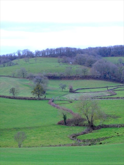
Initialement les haies avaient pour fonction de maintenir les animaux sauvages à l'extérieur et les animaux de l'élevage à l'intérieur de les pâturages. Ils ont également fournissent les animaux, comme les cerfs, les lapins et les oiseaux, avec un abri et un endroit pour élever leurs petits. Mais ils montrent aussi une belle vue panoramique.
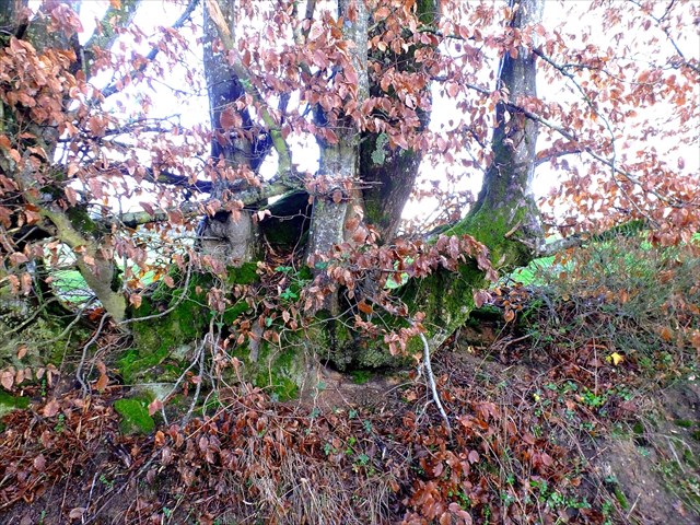
Il existe de nombreux exemples le long du chemin où vous pouvez très bien voir comment les arbres et arbustes ont été engloutis et sont fusionnés pour former des haies. A l'un de ces endroits, le cache est caché.
S'il vous plaît vérifier l'intérieur de la boîte de cache. Vous trouverez un autocollant sur lequel vous pouvez découvrir une TB.
Sur le chemin du retour, vous avez une belle vue sur le Mont Dardon et Uxeau.
This cache will take you on a short walk through the beautiful countryside of the Charolais-Brionnais. If you connect the walk with the cache „Les trois vieux Châtaigniers “ (GC69ZZV) it will be a little less than 3 km long. On this way you might meet Lennon and Luna, two friendly dogs, who choose this path as one of their favorite walks. Each has their TB attached to their collar.
You can park your car at N 46° 39.424' E 4° 00.588'. Please make sure that you will not block the way or the entrance of the field.
Warning! In case of rain the way quickly becomes muddy!
This way is the old road from Uxeau to Bassenier. During the first part of the walk you can see the steeple of the church of La Chapelle-au-Mans in the distance.
There is plenty of wildlife you can see here. Among the wild animals are deer, foxes, herons, buzzards, ravens and jays. And you will see the beautiful Charolais cows in their pastures.
If you look to the north and if you are lucky you will see Gamin, the donkey, a friend of Lennon and Luna.
While you walk, you can admire the groves typical for the Charolais-Brionnais country. Its territory is composed by 85% of meadows, carefully demarcated by hedges. This type of domain boundary was already used by the Celts and is an important part of the heritage of the region. Since 2011, an application to UNESCO is running, to put the groves with their hedges under the World Heritage.
Initially the hedges had the function of keeping wild animals outside and the animals of breeding within the pasture. They also provide animals, such as deer, rabbits and birds, with a shelter and a place to raise their young. But they also make a beautiful panoramic view.
There are many examples along the way where you can see very well how trees and shrubs were formed and merged to make hedges. At one of these places, the cache is hidden.
Please check the bottom inside the cache box. You'll find a sticker on which you can discover a TB.
On the way back, you have a beautiful view to the Mount Dardon and Uxeau.
Dieser Cache führt Euch auf einem kurzen Spaziergang durch die schöne Landschaft des Charolais-Brionnais. Wenn Ihr den Spaziergang mit dem Cache „Les trois vieux Châtaigniers “ (GC69ZZV) verbindet, ist der Weg etwas weniger als 3 km lang. Hier könnt Ihr Lennon und Luna, zwei freundliche Hunde, treffen, die diesen Weg als eine ihrer Lieblings-Gassi-Wege gewählt haben. Jeder der Beiden hat einen TB an seinem Halsband befestigt.
Ihr könnt Euer Auto bei N 46° 39.424' E 4° 00.588' parken. Bitte achtet darauf, dass Ihr den Weg oder den Eingang des Feldes nicht blockiert.
Achtung! Wenn es regnet wird es hier sehr schnell matschig und rutschig!
Dieser Weg ist die alte Straße von Uxeau nach Bassenier. Auf dem ersten Teil der Wanderung könnt Ihr den Turm der Kirche von La Chapelle-au-Mans in der Ferne sehen.
Es gibt viele wilde Tiere hier zu sehen. Unter ihnen sind Rehe, Füchse, Reiher, Bussarde, Raben und Eichelhäher. Und Ihr werdet die schönen Charolais-Kühe in ihren Weiden sehen.
Wenn Ihr nach Norden schaut und wenn Ihr Glück habt, könnt Ihr Gamin, den Esel, einen Freund von Lennon und Luna sehen.
Während des Spaziergangs könnt Ihr die für das Charolais-Brionnais typischen Haine bewundern. Das Gebiet besteht aus 85% Wiesen, sorgfältig durch Hecken abgetrennt. Diese Art der Domängrenzen wurde bereits von den Kelten genutzt und ist ein wichtiger Teil des Erbes der Region. Seit 2011 läuft ein Antrag bei der UNESCO, um die Haine mit ihren Hecken unter das Weltkulturerbe zu stellen.
Ursprünglich hatten diese Sicherungshecken die Funktion die Wildtiere ausserhalb und die landwirtschaftlichen Tiere innerhalb der Weiden zu halten. Sie bieten auch anderen Tieren, wie Rehen, Kaninchen und Vögeln, einen Unterschlupf und einen Ort, um ihre Jungen aufzuziehen. Aber sie ergeben auch ein sehr schönes Panorama.
Es gibt viele Beispiele auf dem Weg, wo man sehr gut sehen kann, wie Bäume und Sträucher verflochten und verbogen wurden, um sie zu Hecken zu bilden. An einem dieser Orte ist der Cache versteckt.
Bitte schaut auf den Innenboden der Cache-Box. Hier findet Ihr einen Aufkleber auf dem man einen TB entdecken kann.
Auf dem Rückweg habt Ihr eine schöne Aussicht auf den Mont Dardon und Uxeau.