Between the Mazatzal Casino and Rye there is a piece of the earth’s crust that is somewhat unusual. It is called the Payson Ophiolite, and it is a fragment of oceanic crust which has been either accreted to, or pushed up onto continental crust. Although there are dozens of such ophiolites around the world, they are truly oddities in that geologists aren't in agreement exactly how they are created. Normally, oceanic crust, which is far denser than continental crust, is subducted under the continent, not thrust up on it. Complicating matters, nowhere in the world is this type of activity happening today.
Oceanic crust is created in a rift zone on the sea floor. This is a zone where two tectonic plates are diverging (pulling apart) and molten magma from the mantle rises to fill the gap. This magma rises in a vertical sheet between the plates and is known as a dike.These dikes eventually cool and solidify until they are ripped apart again, and a new dike is formed between the plates. See figure 1 (below):
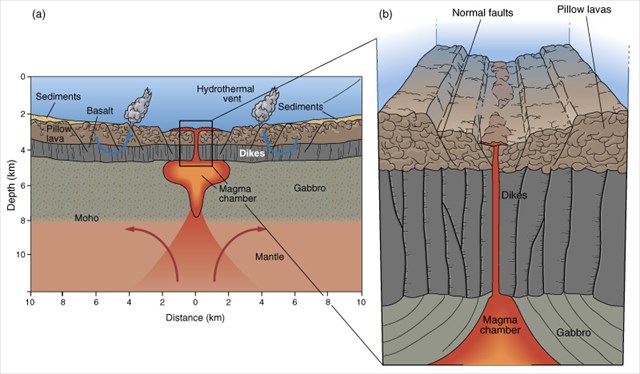
Figure 1: How sheeted dikes are formed.
Geologists are not agreed just how the Payson Ophiolite was created, but many geological features that can be seen today, including sheeted dikes, confirm that this chunk of crust was created under an ocean.
A map of the Payson Ophiolite is shown in Figure 2 below. Sheeted dikes are depicted with slanted lines, very close together. Where these dikes can be seen today is shown by the letter pairs in boxes on the map. Rattlesnake Canyon is designated as the letters "RC" in a box near the south end of the Ophiolite. Other places that sheeted dikes may be seen are AG: American Gulch, SJ: St. John's Creek, and EF: Eastern Flank of the Mazatzal Mountains.

Figure 2: The Payson Ophiolite.
There are several places in Rattlesnake Canyon where you can see the vertically arranged sheeted dikes, especially if you use your imagination, but the given coordinates take you to the most obvious ones. A photo from Ground Zero is presented in Figure 3 below. As you can see from the side view at the very bottom of Figure 2, most of these dikes have eroded off, leaving only the stumps. As you walk down the canyon, in many places you can see the gabbro and diorite basement rocks in the stream bed.

Figure 3: Sheeted Dikes in Rattlesnake Canyon.
To log this cache, you must visit the site and message or email me answers to the following questions:
- How thick, on average, would you say each dike is?
- At what approximate compass alignment are the dikes, i.e. which direction do the faces of the dikes tend?
- If you look closely at some of the dikes, you will see veins of another mineral in them. What color is this other mineral?
For More Information: