There is no parking by the cache, but there are shops and side-streets on both sides of Tewkesbury Road where you may find parking spaces. Please don’t attempt to stop on the dual carriageway at any time of the day or night!
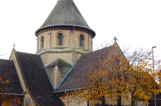
St Peter’s church was built in 1847-49 to serve what was then – and still is – one of Cheltenham’s least affluent areas, offering free sittings at a time when most people had to pay to attend church. The energy and drive behind this was the Rev. Francis Close, whose name is well known from his other church and school projects in the town. He raised the funds to buy two orchard plots on the south side of Tewkesbury Road, in an area which was then known as The Moors. To design the church he commissioned Samuel Whitfield Dawkes, a Gloucester architect who designed many other contributions to the Cheltenham streetscape, including the railway station. The style is Anglo-Norman with a semi-circular apse and a distinctive circular lantern tower, all decorated with faux-Norman dogtooth chevrons.
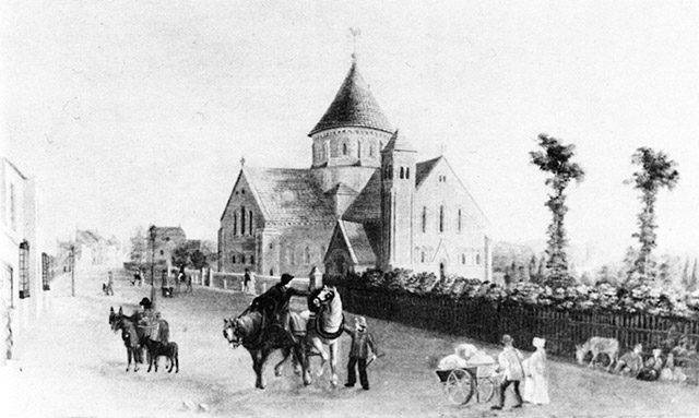
The streetscape of Tewkesbury Road has changed so drastically that it’s hard to imagine what the setting of this church would have been like in the 19th century. Imagine, if you can, a row of Victorian and Regency terraced houses all the way along the north side of the road (with a pub on every corner), and open fields and orchards on the south side where the retail units are now. The drawing below shows the scene in about 1850. The north side of Tewkesbury Road was completely razed when the road was widened into a dual-carriageway in the early 1960s. Shame innit?
****************** ********************
For full information on how you can expand the Church Micro series by sadexploration please read the Place your own Church Micro page before you contact him at churchmicro.co.uk
See also the Church Micro Statistics and Home pages for further information about the series.
****************** *******************