
Węgiel kamienny jest skałą osadową powstałą przez akomodację szczątków roślinnych roślin rosnących na kontynencie. Posiada teksturę warstwową, jest koloru czarnego z tłustym połyskiem. Węgiel kamienny jest odmianą węgla. Inne odmiany to węgiel brunatny, grafit (diament), antracyt. Węgiel kamienny może zawierać inne śladowe ilości minerałów, np. domieszka siarki powoduje pojawienie się pirytu.
Jak powstał węgiel na Ziemi?
Miliony lat temu ląd porastały olbrzymiej wielkości paprocie i skrzypy. W epoce zwanej karbon , mniej więcej 300 milionów lat temu materiał organiczny roślin został zalany przez wodę, przez co zalane rośliny zostały odizolowane od dostępu powietrza, a co za tym idzie od rozkładu materiału organicznego. Płytkie jeziora, laguny i zbiorniki wodne z czasem osadzały na swoim dnie cząstki skał, jeziora zarastały tworząc torfowiska. Te z kolei zostały przykryte warstwami osadowymi , piaskiem i mułem, które z biegiem czasu utworzyły szczelną warstwę skały osadowej. Taka izolacja , przy okazji wysoka temperatura oraz wysokie ciśnienie spowodowane ciężarem skały osadowej zatrzymało procesy utleniania oraz rozkładu substancji organicznej. Bez tleniu nie tylko mikroorganizmy ale też bakterie nie były w stanie przetworzyć szczątków roślinnych. W takim beztlenowym środowisku, z zatrzymanym procesem gnicia następowało stopniowe zagęszczenie materiału lub skamienienia (fosylizacji) . Pierwszą postacią procesu uwęglania stanowi torf.
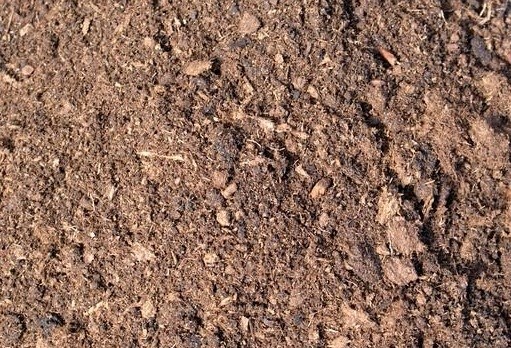
Mianem tym nazywamy skałę, która zawiera 45% - 50% masy węgla pierwiastkowego. Torf powstaje w wyniku procesów chemicznych i organicznych rozpoczętych przez rozpad roślin w jeziorach i bagnach. W takim wilgotnym środowisku woda jest uboga w tlen proces rozkładu zachodzi powoli dzięki bakteriom. Często zdarza się, że obecnie znajdujemy ślady po prehistorycznych zwierzętach lub roślinach uwięzionych i zakonserwowanych w bagnach (skamieniałości). Wyglądem przypomina gąbczastą zbitkę resztek roślin. Torf posiada strukturę włóknistą, pylastą lub spilśnioną; teksturę warstwową lub bezwładną i porowatą, kolor szary. Gołym okiem można zobaczyć i rozpoznać szczątki roślin w postaci gałęzi lub korzeni. Torf jest miękką skałą , która z łatwością kruszy się w palcach
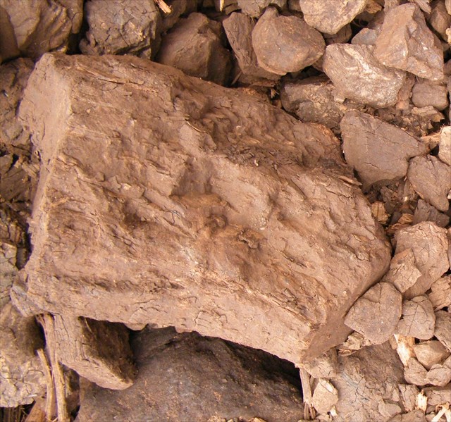
Materiał organiczny ulegał dalszemu przeobrażeniu pod wpływem wysokiej temperatury i ciśnienia oraz dalszemu uwęglaniu tworzył Węgiel kamienny. Jest bardziej energetyczny niż torf, bo zawiera 65% - 85% węgla pierwiastkowego. Węgiel kamienny powstaje z torfu pod wpływem gęstnienia (diagenezy) skały. Potrafimy rozróżnić trzy rodzaje węgla: węgiel brunatny (zabarwienie brunatne, bez połysku, 75% węgla ), węgiel kamienny i antracyt.
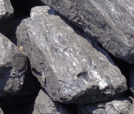
Jeszcze większą zawartość węgla pierwiastkowego zawiera antracyt, w którym zawartość węgla określa się na 90% - 95%. Jest skałą wyjątkowo gęstą o bardzo dużym połysku i intensywnie czarnej barwie. W wyniku procesów górotwórczych pod wpływem działania ciśnienia gór na podłoże pokłady węgla kamiennego ulegały silnej kompresji, przy okazji traciły większość pierwiastków lotnych.
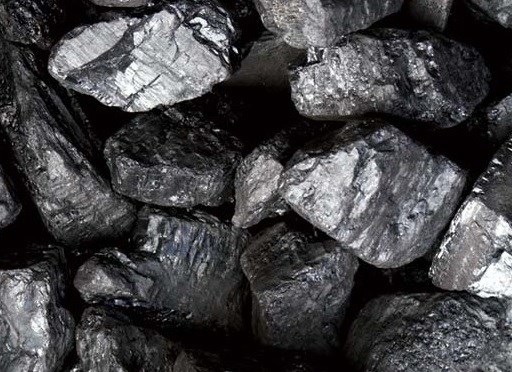
Pisząc o węglu warto jeszcze wspomnieć o dwóch pierwiastkach rodzimych - Graficie oraz Diamencie.
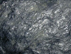
Grafit jest odmianą węgla w postaci miękkiego kryształu (twardość 2 - pomiędzy talkiem a gipsem) o doskonałej łupliwości i czarnej rysie. I właśnie ta cecha sprawia, że jest stosowany jako wkład do ołówków do pisania po papierze. Występuje najczęściej w postaci skupień łuseczkowatych w dotyku tłustych i brudzących o metalicznym połysku. Grafit jest produktem przeobrażenia skał zawierających substancje organiczne i składa się wyłącznie z węgla (metamorfizm kontaktowy).

Kryształ diamentu powstaje w górnym płaszczu ziemskim na głębokości poniżej 100 km o bardzo wysokiej temperaturze i ciśnieniu w skałach zasadowych i przenoszonych na powierzchnię Ziemi w wyniku procesów magmowych. Składa się wyłącznie z węgla pierwiastkowego. Jest jedynym kamieniem szlachetnym zbudowanym z czystego pierwiastka węgla. Diamenty charakteryzują się bardzo dużą twardością (10/10) oraz ze względu na rzadkość występowania - pożądaniem przez płeć piękną :-)
Stratygrafia jest jedną z dyscyplin geologii zajmującą się badaniem budowy warstw wchodzących w skład skorupy ziemskiej. Bardzo ważną rzeczą jest poznanie wieku warstw i porządku w jakim zostały ułożone. Stratygraf w swoich badaniach kieruje się zasadami:
Jeśli skamieniałości pojawiają się w dwóch różnych miejscach warstwy to pochodzą z tego samego okresu
Zjawiska zachodzące obecnie tłumaczą zjawiska zachodzące w przeszłości
Warstwy położone wyżej są młodsze od warstw położonych niżej
Pierwotne ułożenie skał jest zawsze poziome
O warstwach
Skały osadowe podzielone są na poziomy, które ukształtowały się w określonym okresie, w stałych warunkach panujących w środowisku. Każdy z tych poziomów stanowi odrębną warstwę
Proces powstawania warstw związany jest z procesem osadzania (sedymentacji). Powstanie warstw związane jest z przerwaniem procesu osadzania i zmianą warunków środowiska, w których osadzanie zachodziło. Może to być zmiana klimatu, zmianą trasy spływania wody. Kolejne warstwy charakteryzują się innym ziarnem i składem mineralnym, co obecnie możemy zaobserwować zmianą barwy lub struktury warstwy. Ze względu na grawitację osady formują się w układzie poziomym. W miarę a pojawiania się nowych osadów na starych warstwach tworzą się nowe. W wyniku ruchów tektonicznych horyzontalny kierunek warstw może zostać zaburzony.
Warstwa ograniczona jest od dołu i od góry równoległymi płaszczyznami. Górna to strop a dolna to spąg. Wyraźnie zaznaczone granice świadczą o gwałtownej zmianie warunków. Warstwy mają określoną grubość (miąższość) [liczoną w metrach lub centymetrach] i rozciągłość [liczoną w kilometrach].
Warstwa może składać się z mniejszych warstw, które nazywane są laminami [mierzonymi w milimetrach], rozróżnianej poprzez odmienną barwę, teksturę, strukturę. Laminy powstają w tym samym okresie co cała warstwa.
Przywołam tu jeszcze dwa pojęcia dotyczące warstw:
bieg warstwy to azymut, czyli kąt pomiędzy północą a hipotetycznym przecięciem się spągu lub stropu z płaszczyzną poziomą
upad warstwy to kąt pomiędzy poziomem a linią spągu lub stropu
linia upadu jest prostopadła do linii biegu
Ważną cechą warstwy jest też obserwacja czy strop i spąg są równoległo na całej długości warstwy czy może miąższość zmienia się w zależności od miejsca. Warstwowanie może być zatem tabularne (równoległe), klinowe , soczewkowe lub nieciągłe.
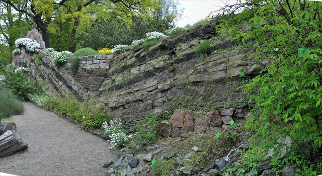
Profil obrazuje złoże węgla kamiennego o strukturze podobnej do złóż występującym w rejonie Wałbrzycha. Profil przedstawia naprzemienny układ warstw piaskowców (szarogłaz) , łupków ilastych i węgla kamiennego.
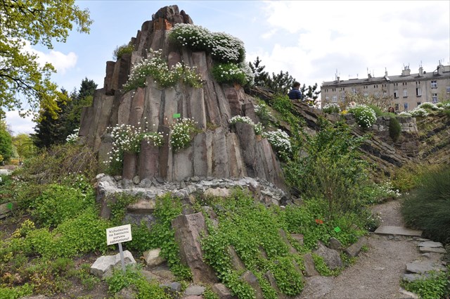
Skrajna lewa strona profilu pokazuje Stożek zbudowany ze słupów z czerwonego porfiru, jaki możemy zobaczyć w rezerwacie przyrody Organy Wielisławickie na Pogórzu Kaczawskim. Skrajny prawy koniec to granit. Kolejne warstwy profilu zbudowane są z węgla oraz piaskowca. Ruchy tektoniczne spowodowały uskok, który został wypełniony czerwonym piaskowcem permskim oraz szarobiałym wapieniem. Przy konstrukcji makiety zostały w profilu umieszczone kamienie z odciskami lub odlewy roślin występujących w karbonie, z których powstał węgiel (Sigillaria, Stigmaria, Lepidodendron, Calamites). Przed profilem zostały ustawione sfosylizowane pnie lasu kambru, z których możemy wyczytać ich pierwotną strukturę. Były tu też współczesne rośliny drzew iglastych , paproci, widłaków, skrzypów i roślin górskich.
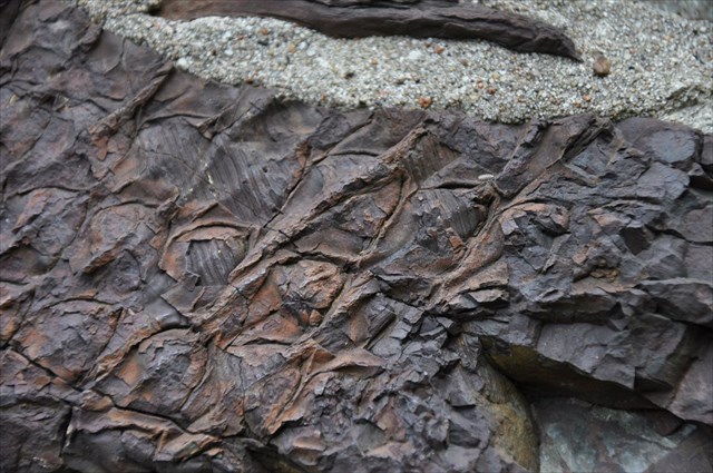
Aby zalogować znalezienie musisz odwiedzić miejsce i wykonać zadania:
1. Oszacuj wysokość i długość profilu.
2. W profilu zauważysz warstwy węgla. Jaki rodzaj węgla rozpoznajesz.
3. Na powyższym zdjęciu widzisz odciski skamieniałości. Na jakiej wysokości znajduje się ten element?
4. Zmierz azymut (najdłuższa płaszczyzna profilu w stosunku do kierunku północnego) oraz kąt nachylenia warstw
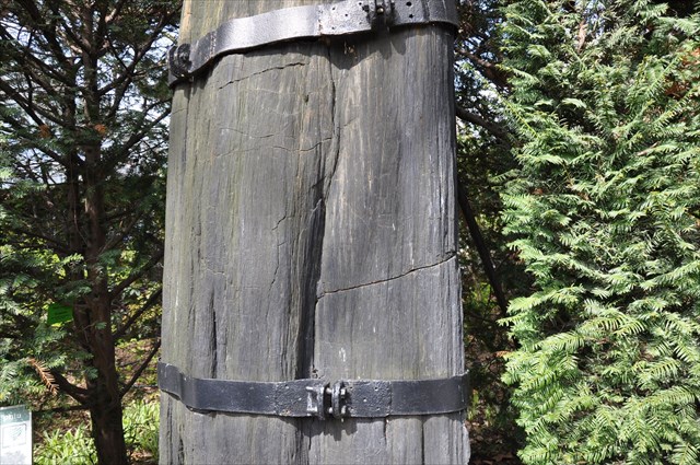
5. W punkcie WP2 znajdziesz skamieniały pień. Oszacuj głębokość pnia (pomnik przyrody).
Odpowiedzi należy przesłać używając formularza kontaktowego na moim profilu. Znalezienie kesza można zalogować zaraz po przesłaniu odpowiedzi - nie musisz czekać na moją odpowiedź. Jeśli coś będzie nie tak, na pewno się odezwę. :) Brak przesłania odpowiedzi będzie powodem usunięcia wpisu "Found it".
Profil geologiczny dostępny jest codziennie od wiosny do jesieni (obecnie 19 marca do 31 października), najczęściej w godzinach 8.00-18.00, w lecie do 20.00. Wymagany zakup biletu wstępu na teren ogrodu.
Podziękowania dla dr Magdaleny Mularczyk za udostępnienie materiałów o profilu: Magdalena Mularczyk: Historia Ogrodu Botanicznego Uniwersytetu Wrocławskiego. Część 1 1811 - 1945 H.R.Goeppert: Steinkohlen- Formation errichtetes Profil. Breslau 1856

The Formation Process of Bituminous Coal
Bituminous coal is a sedimentary rock formed by compression of plant remains. Its texture is stratified and its coloration is black with a dull lustre. It’s one of the types of coal, along with lignite, graphite (diamond) and anthracite. Bituminous coal may contain trace amounts of other minerals, for example, sulphur as a doping agent produces pyrite.
How did the coal on Earth form?
Millions of years ago, the land was covered in giant ferns and horsetails. In the Carboniferous period, around 300 million years ago, a substantial amount of plant matter was submerged in water, which protected it from biodegradation by cutting off the supply of air. In time, plant matter in shallow lakes, lagoons, and other bodies of water deposited minerals in the soil and formed peat bogs. These, in turn, were buried by sediments, sand, and silt, which eventually formed a layer of sedimentary rock. This isolation, along with high temperature and high pressure caused by the weight of sedimentary rocks, stopped the processes of oxidation and biodegradation, since without oxygen the plant remains could neither be processed by microorganisms, nor bacteria. In such anaerobic environment, without putrefaction, the plant material was steadily compressed and fossilised. Thus, peat is the first step in formation of coal.

Peat is composed in about 45-50% of carbon. Its formation is caused by processes of degradation of plant matter in lakes and wetlands. In a wet environment such as this, where oxygen is sparse, putrefaction by bacteria is very slow. That’s why we routinely find traces of prehistoric animals or plants (fossils) trapped and preserved in wetlands. Peat looks like a spongy mixture of plant remains. Its structure can be either fibric, hemic, or sapric, its texture is either stratified and porous, and its colour is gray. Plant remains like branches and roots are visible and recognizable to the naked eye. It’s soft and easily crumbles when crushed between fingers.

The organic material was further transformed by high temperature and pressure and its carbonisation converted it into lignite. Lignite is more energetic than peat, since it’s composed in about about 65-85% of carbon. It’s created from peat as part of a process of compaction (diagenesis). We classify coal into one of three types: lignite (brownish colour, no lustre, about 65% carbon content), bituminous coal, and anthracite.

Carbon content of anthracite is even higher, and stands at about 90-95%. It’s an extremely dense, deep black-coloured rock with a bright lustre. Due to orogenesis, mountains exerted pressure on beds of bituminous coal. As a result, the coal became highly compressed and lost most of its volatile elements.

When writing about coal, we should mention two native element minerals – graphite and diamond.

Graphite is carbon in a form of soft crystals (hardness on the Mohs scale: 2 – between talc and gypsum), easily fractured and with a black streak. That last property makes it ideal for writing in pencil on paper. It’s usually found as platy intergrowths and is greasy and readily marking when touched. Graphite is a result of metamorphism of rocks with organic material and is composed solely of carbon (contact metamorphism).

A diamond crystal is formed in the upper crust, at depths of below 100 km, in very high temperature and pressure, in alkaline igneous rocks transported to the surface by magmatic processes. It’s composed solely of carbon and is the only gemstone composed purely of a chemical element. Diamonds are extremely hard (10 out of 10 on Mohs scale) and, due to their rarity, are coveted by the fairer sex. :-)
Stratigraphy is a branch of geology which studies the composition of layers in the Earth’s crust. It’s very important to determine the ages of these layers and their ordering. Stratigraphers apply the following axioms to their work:
Fossils found in different areas of the same layer come from the same period
Phenomena occurring currently explain phenomena that had occurred in the past
Layers located above are younger than layers located below
Base rock layering is always lateral
About the layers
Sedimentary rocks are divided into layers that formed in different periods, in essentially constant environment conditions. Each of these layers is a different stratum. The stratification process is related to the sedimentation process.
Layers are formed when sedimentation process stops and environment conditions under which sedimentation occurred change. This can be caused by climate or watercourse change. Separate strata are characterised by different grain and mineral composition, which shows as difference in colouration or structure. Gravity causes sediments to deposit laterally. New sediments on older strata form newer ones. Tectonic movements may distort the lateral placement of layers.
A stratum is constrained on top and bottom by parallel surfaces. The top surface is called a ceiling and the bottom one – a thill. Clearly visible boundaries are evidence of a rapid change in conditions. Layers have thickness [measured in metres or centimetres] and horizontal dimensions [measured in kilometres].
A layer may consist of thinner layers called lamins [with thickness measured in millimetres]. These are differentiated by colour, texture, and structure, and are formed with the entire layer.
There are two additional terms concerning strata:
The strike line of a stratum is the azimuth, that is, the angle between the true north and the intersection of a ceiling or thill with a horizontal plane.
The dip of a stratum is the angle of descent of the till or the ceiling relative to the horizontal plane.
Another important property of a stratum is whether its ceiling and thill are parallel along the entire length or if its thickness varies. Stratification can be thus categorised into tabular (or planar), wedge, trough, and unconformable.

The following profile shows a coal bed with structure similar to deposits found around Wałbrzych. We can distinguish alternating layers of sandstone (Greywacke), shale and bituminous coal..

The leftmost side of this profile shows a cone consisting of vertical formations of red porphyry, which can be seen in Organy Wielisławickie preserve on the Pogórze Kaczawskie. The rightmost side is granite. Another layers of the profile are formed from coal and sandstone. Tectonic movements created a fault that was filled with red Permian sandstone and greyish-white limestone. The mockup was also seeded with stones containing either external or internal molds of plants existing in the Carboniferous, when coal was formed (Sigillaria, Stigmaria, Lepidodendron, Calamites). In front of the profile, we can observe fossilized trunks of a Cambrian forest, illustrating their original structure. There are also contemporary plants, in the form of conifers, ferns, ground pines, horsetails, and mountain vegetation..

To log a find, you must visit the place and perform the following tasks::
1. Estimate the height and length of the profile.
2.The profile contains seams of coal. What type/s do you recognize?
3.The photo above shows fossil molds. At what height of the profile can you find these?
4. Measure the azimuth (the angle between the longest plane of the profile and the true north) and the dip of profile layers.
5. At point WP2 you will find a fossilized trunk. Estimate its depth (a natural monument).
Responses should be sent by using the contact form on my profile. Finding the cache, you can log in immediately after sending the response - no need to wait for my answer. If something goes wrong, you are sure to appeal. :) No message response will result in the removal of entry "Found it." Geological profile is available every day from spring to autumn (currently 19 March to 31 October), most often in the 8.00-18.00, in the summer for 20.00. Requires purchase of an admission ticket to the garden area.

Many thanks do dr Magdalena Mularczyk for sharing the information about the profile: Magdalena Mularczyk: Historia Ogrodu Botanicznego Uniwersytetu Wrocławskiego. Część 1 1811 - 1945 H.R.Goeppert: Steinkohlen- Formation errichtetes Profil. Breslau 1856