
 Sequit Point is part of Leo Carrillo State Park. If you use the State Park parking lots there is an entrance fee. If you can find parking along PCH be sure to follow the parking restrictions and use extreme caution crossing the road. Use appropriate trails going down to the caves. Be sure to evaluate the tides and waves to be sure it is safe to go down to the caves.
Sequit Point is an outcropping of the Upper Topanga Formation. This formation is a light gray sandstone that was deposited in the Middle Miocene (17-13 million years ago). These sediments were deposited in a shallow marine environment. This sandstone formation is hard and relatively resistant to erosion.
Because these rocks are resistant to erosion, in order to create a cave, erosional forces need to find some point of weakness in the rock. These weak spots are along joints and faults that have formed in the rock. In this sandstone formation, joints are cracks in the rock that have formed from the rock expanding after being buried.. Essentially no movement occurs across a joint, unlike a fault. A fault is a crack in the rock along which the rocks move relative to each other.
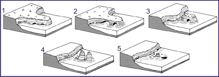 In either case, the resulting crack is a weak spot in the rock where the waves are able to remove pieces of the rock faster than in the surrounding rock. Thus caves form along these cracks.
Waves pound the cliff faces with hundreds of pounds of force per wave eroding away the base of the cliffs. Where there are areas of weakness, that portion of the cliff erodes forming indentations. These indentations reinforce the erosion by focusing more energy from each wave into the confined space creating caves.
Continued erosion eventually erodes the cliffs and caves down, sometimes isolating remnants of the cliff off-shore in what are called sea stacks.
Logging requirements:
Send me a note with :
- The text "GC6A64D Sequit Point Sea Caves " on the first line.
- The number of people in your group.
- Examine the caves to determine where in the cave, the weak spot is that is creating the cave?
- Based on where the weak spot is and the shape of the cave you chose to examine, what direction is the cave growing?
- Are all the places the waves have eroded remained caves? (Look at Stage 2)
- How many sea stacks have formed from the continued erosion of the littoral caves?
The above information was compiled from the following sources:
- http://en.wikipedia.org/wiki/Sea_caves
- Bird, E, 2008. Coastal Geomorphology: An introduction. John Wiley and Sons, Ltd.
- http://teacher.scholastic.com/lessonrepro/lessonplans/theme/caves04.htm
- http://en.wikipedia.org/wiki/Sea_caves
- Bird, E, 2008. Coastal Geomorphology: An introduction. John Wiley and Sons, Ltd.
- http://teacher.scholastic.com/lessonrepro/lessonplans/theme/caves04.htm
- Dibblee, T.W., and Ehrenspeck, H.E., 1990, Geologic map of the Point Mugu and Triunfo Pass quadrangles, Ventura and Los Angeles Counties, California: Dibblee Geological Foundation, Dibblee Foundation Map DF-29, scale 1:24,000
- County of Los Angeles Department of Regional Planning 2014, Santa Monica Mountains Local Coastal Program Technical Appendices, January 2014
- Hall, Clarence A. Jr., Introduction to the Geology of Southern California and Its Native Plants. University of California Press. Copyright.