The steep lower bank, at the southern end of the Down, has been fenced off to form a paddock for the "Pewley Cattle" that can sometimes be seen grazing here. These three Highland cows (Thisbie, Fiona and Yak) have been introduced to reduce the height and density of the grass sward and to help control invasive scrub.
From Pewley Down there are great views over to the Chantries and St Martha's Hill.

Now on to the EarthCache!
The rock types in the Guildford area are all sedimentary and were originally set down as water-borne deposits in horizontal layers (strata), so the rocks at the top are the youngest and the rocks become older down through the strata sequence.
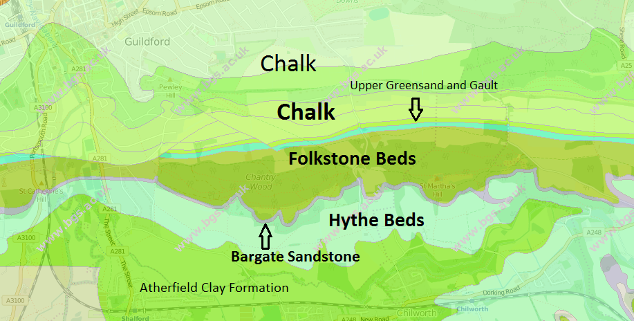
Pewley Down is made of Chalk (Lewes Nodular Chalk Formation to be precise!). This was deposited in a shallow tropical sea, about 180m deep, (like the Caribbean today) as a lime-rich mud composed of microscopic skeletal fragments of algae with the remains of sponges (becoming flint) and sea urchins (fossilised as echinoids) being deposited in layers when the sea was very shallow. The Chalk is about 95% calcium carbonate and is fairly soft limestone, although it is harder than most rocks in the area. Upper Chalk forms the crest of Pewley Down, then slightly off the top of Pewley Down is the Middle Chalk which is rich in flints, then below that is the Lower Chalk which is a dull grey Marl (a mix of lime and clay). The Chalk is permeable and an aquifer (it stores water in a natural underground reservoir, the top of which is known as the water table). During past periglacial conditions, permafrost made the surface impermeable, allowing meltwater surface streams in summer to cut valleys that no longer have surface streams within them, such dry valleys are very common on the dip slope and the scarp slope of Pewley Down.
The North Downs Way sit on the Folkstone Beds which is part of the Lower Greensand group. The Folkstone Beds consist of loosely consolidated sand grains, deposited In an inshore area of sea with strong currents and with sand dunes just onshore. The sand grains are cemented together by iron compounds, which are oxidised when exposed to air, causing the sand grains to become loose and stained yellow or orange (this is especially obvious on the nearby St Martha's hill). Within the sandstone are veins of hard ironstone called carstone. All of the sandstones are permeable and are aquifers (i.e. it stores water in a natural underground reservoir the top of it is called the water table). The Folkstone Beds often form an escarpment (steep slope) in the area. The Bargate Beds (they are start just off the escarpment to the south of GZ) are about 20 meters thick and have little effect on relief, but the hard sandstone is sometimes quarried to use as a building stone: its sand grains are held together by a calcium carbonate cement, so it is not stained red and looks like a course grained Chalk. The Hythe Beds start 20 or so meters from the top of the escarpment. They consist of a greyish-green sandstone and some dinosaur fossils have been found in it.
Gault is a rock formation of stiff blue clay or mudstone with a sandy base, deposited in a calm, fairly deep water marine environment during the Lower Cretaceous Period.
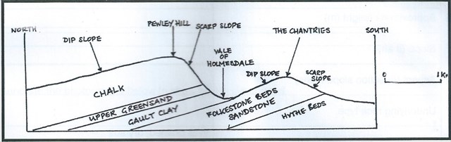
All of the rock in the Guildford area were uplifted and folded during the mountain building period of the Alpine Orogeny that occurred about 25 million years ago. This area was at the northern edge of the folding and the Alps were formed by the same event. The rocks were folded into a compound anticline called an anticlinorium and this Wealden Anticline has subsequently been denuded, exposing the older rocks between the overlying Chalk. The axes of the folds run east-west
Questions
Start at Pewley Down
- Why is Pewley Down higher than the rest of the surrounding area?
- Estimate how deep down is the bedrock (the Chalk)? (You may see the bedrock on the sides of well used paths)
Go to The North Downs Way (Waypoint below)
- How deep down is the bedrock? (You may see the bedrock on the sides of the path)
- This is the best example of the colour of the bedrock, what colour is it?
Go to the Chantries Car Park (Waypoint below)
- There is an obvious feature which shows why this bedrock is different to that of the surrounding area, what is it?
- What is different about this bedrock, why is the feature from the question above here?
- Optional take a picture of yourself
Please email me the answers and don't leave any clues in the logs!
I will delete any peoples finds who don't email me the answers
This is my first EarthCache so please leave feedback.